This is a list of mountains in Cabo Verde:
Contents


This is a list of mountains in Cabo Verde:

Cape Verde is a group of arid Atlantic islands which are home to distinct communities of plants, birds, and reptiles. The islands constitute the unique Cape Verde Islands dry forests ecoregion, according to the World Wildlife Fund.

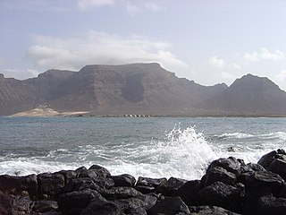
São Vicente is one of the Barlavento Islands, the northern group within the Cape Verde archipelago in the Atlantic Ocean, off the West African coast. It is located between the islands of Santo Antão and Santa Luzia, with the Canal de São Vicente separating it from Santo Antão.
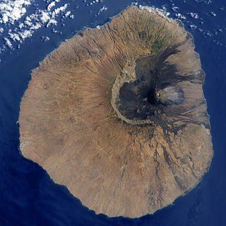
Fogo is an island in the Sotavento group of Cape Verde. Its population is 35,837 (2015), with an area of 476 km2. It reaches the highest altitude of all the islands in Cape Verde, rising to 2,829 metres above sea level at the summit of its active volcano, Pico do Fogo.

Brava is an island in Cape Verde, in the Sotavento group. At 62.5 km2 (24.1 sq mi), it is the smallest inhabited island of the Cape Verde archipelago, but at the same time the greenest. First settled in the early 16th century, its population grew after Mount Fogo on neighbouring Fogo erupted in 1680. For more than a century, its main industry was whaling, but the island economy is now primarily agricultural.

Santo Antão is the westernmost island of Cape Verde. At 785 km2 (303 sq mi), it is the largest of the Barlavento Islands group, and the second largest island of Cape Verde. The nearest island is São Vicente to the southeast, separated by the sea channel Canal de São Vicente. Its population was 38,200 in mid 2019, making it the fourth most populous island of Cape Verde after Santiago, São Vicente and Sal. Its largest city is Porto Novo located on the southern coast.

Santa Luzia is an island of the Barlavento archipelago in Cape Verde located between São Nicolau and São Vicente, the channel of Santa Luzia separates the island of São Vicente and is 8 km wide. The area is 34.2 km². Like all Cape Verdean islands, it is of volcanic origin. The highest point is Topona. Santa Luzia is 12.4 km long and 5.3 km wide.

São Nicolau is one of the Barlavento (Windward) islands of Cape Verde. It is located between the islands of Santa Luzia and Sal. Its population is 12,424 (2015), with an area of 343 km2 (132 sq mi). The main towns are Ribeira Brava and Tarrafal de São Nicolau.

Boa Vista, also written as Boavista, is a desert-like island that belongs to the Cape Verde Islands. At 631.1 km2 (243.7 sq mi), it is the third largest island of the Cape Verde archipelago.

Santiago is the largest island of Cape Verde, its most important agricultural centre and home to half the nation's population. Part of the Sotavento Islands, it lies between the islands of Maio and Fogo. It was the first of the islands to be settled: the town of Ribeira Grande was founded in 1462. Santiago is home to the nation's capital city of Praia.

São Lourenço dos Órgãos is a concelho (municipality) of Cape Verde. It is situated in the mountainous central part of the island of Santiago. Its seat is the city João Teves. Its population was 7,388 at the 2010 census, and its area is 36.9 km2. The municipality is bordered by Santa Cruz to the northeast, São Domingos to the south, Ribeira Grande de Santiago to the southwest and São Salvador do Mundo to the northwest. Pico de Antónia, the island's highest mountain, straddles the borders of São Lourenço dos Órgãos, São Salvador do Mundo and Ribeira Grande de Santiago.
Monte Verde is a mountain in the eastern part of the island of São Vicente, Cape Verde. At 744 m elevation, it is the island's highest point. The mountain is located 6 km (4 mi) east of the city centre of Mindelo.
Picos, also known as Achada Igreja, is a city in the central part of the island of Santiago, Cape Verde. It is the seat of São Salvador do Mundo municipality. Picos is located 4 km southeast of Assomada and 23 km northwest of the capital city of Praia, near the national road from Praia to Tarrafal via Assomada (EN1-ST01).
Monte Gordo is a mountain on the island of São Nicolau, Cape Verde. At 1,312 m elevation, it is the island's highest point. It is situated in the western part of the island, 6 km west of the island capital Ribeira Brava. The mountain is of volcanic origin, less than 1 million years old. The boundary of the municipalities Tarrafal de São Nicolau and Ribeira Brava runs over the mountain. It is part of the Monte Gordo Natural Park.

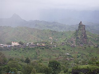
Pico de Antónia is a mountain located in the central part of the island of Santiago in Cape Verde. At 1,392 m (4,567 ft), it is the highest point of the island. The mountain is part of the protected area Parque Natural da Serra do Pico de Antónia. The towns Picos and Assomada lie close to the mountain. The Serra do Pico da Antónia has been identified by BirdLife International as an Important Bird Area.
Serra Malagueta is a mountain range located in the northern part of the island of Santiago, Cape Verde. At 1064 m elevation, it is highest point of northern Santiago. The mountain range is protected as the Serra Malagueta Natural Park, that was established on February 24, 2005 and covers 774 hectares. The natural park is situated in the municipalities Tarrafal, São Miguel and Santa Catarina. The summit is in São Miguel, south of the Ribeira Principal valley. The Serra Malagueta formation is of volcanic origin, and was formed between 2.9 and 2.4 million years ago.
Baleia is a mountain valley in the eastern part of the island of São Vicente. Its orientation is west-east, and it lies south of Baía das Gatas and northwest of the beach Praia Grande. At its western end is Monte Verde, the highest point of São Vicente. At its eastern end is the Atlantic Ocean. Access is either from the coast or from Mato Inglês over a mountain pass.

Cape Verde or Cabo Verde, officially the Republic of Cabo Verde, is an archipelago and island country in the central Atlantic Ocean, consisting of ten volcanic islands with a combined land area of about 4,033 square kilometres (1,557 sq mi). These islands lie between 600 to 850 kilometres west of Cap-Vert, the westernmost point of continental Africa. The Cape Verde islands form part of the Macaronesia ecoregion, along with the Azores, the Canary Islands, Madeira, and the Savage Isles.
1910s – 1920s – 1930s – 1940s – 1950s – 1960s – 1970s – 1980s – 1990s – 2000s

Farol de D. Luis is a lighthouse on the islet of Ilhéu dos Pássaros, 1.3 km off the coast of the island of São Vicente, Cape Verde. It lies at the entrance to the Porto Grande Bay from the Canal de São Vicente, the strait between São Vicente and Santo Antão. The lighthouse sits atop the highest point of the islet, and is connected to the keepers house halfway down the slope by a stairway. The lighthouse was built around 1882, and was named after king Luís I of Portugal. It is a white hexagonal tower with a small lantern, total height five metres. Its focal height is 86 metres, and its range is 14 nmi.
Longueira is a village in the southcentral part of the island of Santiago, Cape Verde. In 2010 its population was 326. Longueira is located 4 km southwest of João Teves and 1.5 km west of São Jorge. Monte Tchota, the highest point of the mountains of Rui Vaz, lies to the south.