
Lebanon is a small country in the Eastern Mediterranean, located at approximately 34˚N, 35˚E. It stretches along the eastern shore of the Mediterranean Sea and its length is almost three times its width. From north to south, the width of its terrain becomes narrower. Lebanon's mountainous terrain, proximity to the sea, and strategic location at a crossroads of the world were decisive factors in shaping its history.
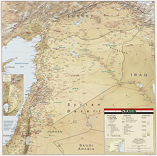
Syria is located in West Asia, north of the Arabian Peninsula, at the eastern end of the Mediterranean Sea. It is bordered by Turkey to the north, Lebanon and Israel to the west and southwest, Iraq to the east, and Jordan to the south. It consists of mountain ranges in the west and a steep area inland. In the east is the Syrian Desert and in the south is the Jabal al-Druze Range. The former is bisected by the Euphrates valley. A dam built in 1973 on the Euphrates created a reservoir named Lake Assad, the largest lake in Syria. The highest point in Syria is Mount Hermon on the Lebanese border at 2,814 metres or 9,232 feet. Between the humid Mediterranean coast and the arid desert regions lies a semiarid steep zone extending across three-quarters of the country, which receives hot, dry winds blowing across the desert. Syria is extensively depleted, with 28 percent of the land arable, 4 percent dedicated to permanent crops, 46 percent utilized as meadows and pastures, and only 3 percent forest and woodland.

The Anti-Lebanon mountains are a southwest–northeast-trending, c. 150 kilometres long mountain range that forms most of the border between Syria and Lebanon. The border is largely defined along the crest of the range. Most of the range lies in Syria.

Mount Lebanon is a mountain range in Lebanon. It is about 170 km (110 mi) long and averages above 2,500 m (8,200 ft) in elevation, with its peak at 3,088 m (10,131 ft). The range provides a typical alpine climate year-round.
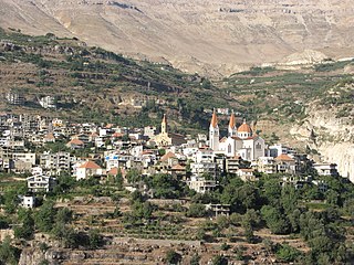
Bsharri is a town at an altitude between 1,100 m (3,600 ft) to 3,088 m (10,131 ft). It is located in the Bsharri District of the North Governorate in Lebanon. Bsharri is the site of the only remaining original "Cedars of God", and is the birthplace of the famous poet, painter and sculptor Khalil Gibran. A museum in the town honours his life and work.

North Lebanon is the northern region of Lebanon comprising the North Governorate and Akkar Governorate. On 16 July 2003, the two entities were divided from the same province by former Prime Minister Rafik Hariri. The division was known as Law 522.

Chouf is a historic region of Lebanon, as well as an administrative district in the governorate (muhafazat) of Mount Lebanon.

Qurnat as Sawdā (Arabic: القرنة السوداء) is the highest point in Lebanon and the Levant, at 3,088 m (10,131 ft) above sea level. It is found at the peak of Jabal al Makmel, a mountain range in the Bsharri District, North Lebanon.

Lake Qaraoun is an artificial lake or reservoir located in the southern region of the Beqaa Valley, Lebanon. It was created near Qaraoun village in 1959 by building a 61 m-high (200 ft) concrete-faced rockfill dam in the middle reaches of the Litani River. The reservoir has been used for hydropower generation, domestic water supply, and for irrigation of 27,500 ha.
Mount Simeon or Mount Simon, also called Mount Laylūn (Arabic: جبل ليلون, is a highland region in Aleppo Governorate in northern Syria. The mountain is located in the Mount Simeon and Aʻzāz districts of Aleppo Governorate.

The following outline is provided as an overview of and topical guide to Lebanon:

Agriculture in Lebanon is the third most productive sector in the country after the tertiary and industrial sectors. It contributes 3.1% of GDP and 8 percent of the effective labor force. The sector includes an informal Syrian labor and is dependent on foreign labor for its productivity. Main crops include cereals, fruits and vegetables, olives, grapes, and tobacco, along with sheep and goat herding. Mineral resources are limited and are only exploited for domestic consumption. Lebanon, which has a variety of agricultural lands, from the interior plateau of the Beqaa Valley to the narrow valleys leading downward to the sea, enables farmers to grow both European and tropical crops. Tobacco and figs are grown in the south, citrus fruits and bananas along the coast, olives in the north and around the Shouf Mountains, and fruits and vegetables in the Beqaa Valley. More exotic crops include avocados, grown near Byblos, and hashish. Although the country benefits from favorable farming conditions and diverse microclimates, it relies on food imports, which make up 80% of its consumption.

The Lebanon Mountain Trail is a long-distance hiking trail in Lebanon. It extends from Andaket in north of Lebanon to Marjayoun in the south along a 470 km (290 mi) path that transects more than 76 towns and villages at altitudes ranging from 570 to 2,073 meters above sea level.

The Coastal Mountain Range also called Jabal al-Ansariya, Jabal an-Nusayria or Jabal al-`Alawīyin is a mountain range in northwestern Syria running north–south, parallel to the coastal plain. The mountains have an average width of 32 kilometres (20 mi), and their average peak elevation is just over 1,200 metres (3,900 ft) with the highest peak, Nabi Yunis, reaching 1,562 metres (5,125 ft), east of Latakia. In the north the average height declines to 900 metres (3,000 ft), and to 600 metres (2,000 ft) in the south.

Zahlé is a city in eastern Lebanon, and is the capital and the largest city of Beqaa Governorate, Lebanon. With around 150,000 inhabitants, it is the third-largest city in Lebanon after Beirut and Tripoli and the fourth-largest taking the whole urban area.
Jabal es Saaïdé, Jabal es Saaide, Jabal as Sa`idah, Jabal as Sa`īdah, Jebal Saaidé, Jebel Saaidé or Jabal Saaidé is a Mountain in Lebanon near the inhabited village of Saaïdé, approximately 12 kilometres (7.5 mi) northeast of Baalbek, Lebanon.

The Temples of the Beqaa Valley are a number of shrines and Roman temples that are dispersed around the Beqaa Valley in Lebanon. The most important and famous are those in Roman Heliopolis. A few temples are built on former buildings of the Phoenician & Hellenistic era, but all are considered to be of Roman construction and were started to be abandoned after the fourth century with the fall of the Roman Paganism.
Forests cover 13.6% of Lebanon, and other wooded lands represents 11%. Since 2011, more than 600,000 trees, including cedars and other native species, have been planted throughout Lebanon as part of the Lebanon Reforestation Initiative (LRI). More reforestation efforts are needed. For example, the 40 hectares of Cedrus libani at Al Shouf Cedar Nature Reserve could be expanded to 3,000 hectares. The Friends of the Cedar Forest Committee planted 200,000 cedars, with 180,000 surviving. The Committee goal was to create a corridor connecting the cedar forests o of Bcharre, Ehden, and Tannourine with each other to create an ecosystem in order to make the forests more resilient to future environmental pressures.

Akkar Governorate is the northernmost governorate of Lebanon. It comprises the single district of Akkar, which in turn is subdivided into 121 municipalities. The capital is at Halba. It covers an area of 788 km2 (304 sq mi) and is bounded by the Mediterranean Sea to the west, North Governorate to the south, Baalbek-Hermel Governorate to the southeast, and the Syrian governorates of Tartus and Homs to the north and northeast. The governorate's western coastal plain constitutes Lebanon's second largest agricultural region after the Beqaa Valley, while the east features forested mountains that have been considered for protection as a national park.

Saghbine, is a village located in the Western Beqaa District of the Beqaa Governorate in Lebanon.
