List of states and union territories of India by sex ratio

Last updated

Map indicating the human sex ratio by country.
.mw-parser-output .legend{page-break-inside:avoid;break-inside:avoid-column}.mw-parser-output .legend-color{display:inline-block;min-width:1.25em;height:1.25em;line-height:1.25;margin:1px 0;text-align:center;border:1px solid black;background-color:transparent;color:black}.mw-parser-output .legend-text{}
Countries with more females than males
Countries with more males than females
Countries with very similar proportions of males and females (to 3 significant figures, i.e., 1.00 males to 1.00 females)
No data Sex ratio total population 2020.svg
Map indicating the human sex ratio by country.
  Countries with more females than males
  Countries with more males than females
  Countries with very similar proportions of males and females (to 3 significant figures, i.e., 1.00 males to 1.00 females)
  No data
Sex ratio in India for census years 1931 to 2011 (in blue). The urban sex ratio (green) between 1951 and 2011 is consistently lower than the rural sex ratio (orange). [2] [3] The red line is the estimate of sex ratio at birth according to the National Family Health Survey 4. [4]

Sex ratio is used to describe the ratio of females to males in a population. In India, the sex ratio has been estimated via a number of methods and data sets including the decennial censuses, the National Family Health Surveys (NFHS), the Civil Registration System, the Sample Registration System and the Health Management Information System. [5] In 2014, the ratio of female births per 1000 male births varied from 887 to 918 using these estimates. [6] According to the NFHS-4 (2015–16) sex ratio of the total population (females per 1,000 males) was 991 (with an urban ratio of 956 and a rural ratio of 1,009). [4]

Contents

In 2011–2013, it was revealed through a population census with the Sample Registration System (SRS) that the sex ratio of India was 909 females per 1000 of males. [7] It has skewed downwards from then, recording 900 females in 2013–2015 and 896 in 2015–17 per 1000 of males. [7] [8] Furthermore, that survey conducted with the SRS also showed Chhattisgarh as the highest sex ratio at 961, while Haryana was recorded the lowest at 831. [8]

The male-skew in India's sex ratio has increased since the early 20th century. In 1901 there were 3.2 million fewer women than men in India, but by the 2001 Census the disparity had increased by more than a factor of 10, to 35 million. [9] This increase has been variously attributed to female infanticide, selective abortions (aided by increasing access to prenatal sex discernment procedures), and female child neglect. [9] It has been suggested that the motivation for this selection against female children is due to the lower status and perceived usefulness of women in India's patriarchal society.

Ranking of states and union territories

Map showing the sex ratio of each district in India based on the 2001 census data. India sex ratio map en.svg
Map showing the sex ratio of each district in India based on the 2001 census data.

In the table below, the rank numbers represented by 'S' are for states while 'UT' are for union territories. The data in the table is based on the population census of 2001 and 2011.

No.State/ Union TerritoryNHFS-52011 Census2001 CensusChange (2001 to 2011)
Rank (Sex ratio at birth)Sex ratio at birth [10] Sex ratioChild sex ratio [11] Sex ratio [12] [lower-alpha 1] Child sex ratio [11] Sex ratio [12] Child sex ratio
1 Lakshadweep UT11051947911948959Decrease2.svg (−1)Decrease2.svg (−48)
2 Tripura S11028960957948966Increase2.svg (12)Decrease2.svg (−9)
3 Meghalaya S2989989970972973Increase2.svg (17)Decrease2.svg (−3)
4 Uttarakhand S3984963890962908Increase2.svg (1)Decrease2.svg (−18)
5 Arunachal Pradesh S4979938972893964Increase2.svg (45)Increase2.svg (8)
6 Karnataka S5978973948965946Increase2.svg (8)Increase2.svg (2)
7 Jammu and Kashmir [lower-alpha 2] UT2976889862892941Decrease2.svg (−3)Decrease2.svg (−79)
8 West Bengal S6973950956934960Increase2.svg (16)Decrease2.svg (−4)
9 Mizoram S7969976970935964Increase2.svg (41)Increase2.svg (6)
10 Sikkim S8969890957875963Increase2.svg (15)Decrease2.svg (−6)
11 Manipur S9967992930978957Increase2.svg (14)Decrease2.svg (−27)
12 Assam S10964958962935965Increase2.svg (23)Decrease2.svg (−3)
13 Chhattisgarh S11960991969989975Increase2.svg (2)Decrease2.svg (−6)
14 Puducherry UT395910379671001967Increase2.svg (36)Steady2.svg
15 Madhya Pradesh S12956931918919932Increase2.svg (12)Decrease2.svg (−14)
16 Gujarat S13955919890920883Decrease2.svg (−1)Increase2.svg (7)
17 Kerala S1495110849641058960Increase2.svg (26)Increase2.svg (4)
18 Nagaland S15945931943900964Increase2.svg (31)Decrease2.svg (−21)
19 Uttar Pradesh S16941912902898916Increase2.svg (14)Decrease2.svg (−14)
20 Andhra Pradesh S17934993939978961Increase2.svg (15)Decrease2.svg (−22)
India929943919933927Increase2.svg (10)Decrease2.svg (−8)
21DelhiUT4923868871821868Increase2.svg (47)Increase2.svg (3)
22 Andaman and Nicobar Islands UT5914876968846957Increase2.svg (30)Increase2.svg (11)
23 Maharashtra S18913929894922913Increase2.svg (7)Decrease2.svg (−19)
24 Bihar S19908918935919942Decrease2.svg (−1)Decrease2.svg (−7)
25 Punjab S20904895846876798Increase2.svg (19)Increase2.svg (48)
26 Jharkhand S21899948948941965Increase2.svg (7)Decrease2.svg (−17)
27 Telangana [lower-alpha 3] S22894988 [13] ---
28 Odisha S23894979941972953Increase2.svg (7)Decrease2.svg (−12)
29 Haryana S24893879834861819Increase2.svg (18)Increase2.svg (15)
30 Rajasthan S25891928888921909Increase2.svg (7)Decrease2.svg (−21)
31 Tamil Nadu S26878996943987942Increase2.svg (9)Increase2.svg (1)
32 Himachal Pradesh S27875972909968896Increase2.svg (4)Increase2.svg (13)
33 Goa S28838973942961938Increase2.svg (12)Increase2.svg (4)
34 Chandigarh UT6838818880777845Increase2.svg (41)Increase2.svg (35)
35 Dadra and Nagar Haveli [lower-alpha 4] UT7817774926812979Decrease2.svg (−38)Decrease2.svg (−53)
36 Daman and Diu UT8817618904710926Decrease2.svg (−92)Decrease2.svg (−22)
Notes
  1. "Child sex ratio" is the ratio of girls to boys in the age group of 0–6 years.
  2. At the time of the census, Jammu and Kashmir was a state but from 31 October 2019, it has been split into two union territories, namely Jammu and Kashmir and Ladakh.
  3. At the time of the census Telangana was a part of Andhra Pradesh. Telangana was declared as a separate state in 2014.
  4. At the time of the census Dadra and Nagar Haveli and Daman and Diu were separate union territories. They became one union territories, Dadra and Nagar Haveli and Daman and Diu, in 2020.

See also

Related Research Articles

<span class="mw-page-title-main">States and union territories of India</span> Indian national administrative subdivisions

India is a federal republic comprising 28 states and 8 union territories. The states and union territories are further subdivided into districts and smaller administrative divisions.

<span class="mw-page-title-main">Dadra and Nagar Haveli</span> District in Western India

Dadra and Nagar Haveli is a district of the union territory of Dadra and Nagar Haveli and Daman and Diu in western India. It is composed of two separate geographical entities: Nagar Haveli, wedged in between Maharashtra and Gujarat states 1 kilometre (0.62 mi) to the north-west, and the smaller enclave of Dadra, which is surrounded by Gujarat. Silvassa is the administrative headquarters of Dadra and Nagar Haveli.

<span class="mw-page-title-main">Daman and Diu</span> Former union territory in western India

Daman and Diu was a union territory in northwestern India. With an area of 112 km2 (43 sq mi), it was the smallest administrative subdivision of India on the mainland. The territory comprised two districts, Daman and Diu island, geographically separated by the Gulf of Khambat. The state of Gujarat and the Arabian Sea bordered the territory. A Portuguese colony since the 1500s, the territories were taken by India with the Annexation of Goa in 1961. Daman and Diu were administered as part of the union territory of Goa, Daman and Diu between 1961 and 1987, after the Goa Opinion Poll they became a separate union territory. In 2019, legislation was passed to merge the union territory of Daman and Diu with its neighbouring union territory, Dadra and Nagar Haveli, to form the new union territory of Dadra and Nagar Haveli and Daman and Diu with effect from 26 January 2020.

<span class="mw-page-title-main">Silvassa</span> City in DNDD, India

Silvassa is a city and municipality in western India, and the headquarters of the Dadra and Nagar Haveli district. It was a part of the Daman district of the former Portuguese India, and is today the largest city in Dadra and Nagar Haveli and Daman and Diu. Many large companies have established their manufacturing units there. The city has a large number of factories providing significant government revenue, which allows the city to maintain a low level of taxation. The city was chosen as one of the hundred Indian cities in Government of India's flagship Smart Cities Mission.

<span class="mw-page-title-main">Vapi</span> City in Gujarat, India

Vapi, is a city and Municipal Corporation in Valsad district in the state of Gujarat, India. It is situated near the banks of the Daman Ganga River, around 28 km south of the district headquarters in the city of Valsad, and it is surrounded by the Union Territory of Dadra and Nagar Haveli and Daman and Diu. It is believed that the city got its name from the old small stepwell situated near the Balitha area. The meaning of vapi (वापी) in sanskrit is a water reservoir or a water storage body.

Daman district, is one of four districts of the Indian union territory of Dadra and Nagar Haveli and Daman and Diu on the west coast of India. It is surrounded by the Valsad district of the Gujarat state to the north, east and south and the Arabian Sea to the west. The district has an area of 72 square kilometres (28 sq mi), and a population of 191,173 as of the 2011 census, an increase of 69.256% from the 2001 Census. The district headquarters is Daman. The previous territorial headquarters were in Panjim when it was jointly administered as Goa, Daman and Diu until the time of the Konkani language agitation.

<span class="mw-page-title-main">Diu, India</span> City in Dadra and Nagar Haveli and Daman and Diu, India

Diu, also known as Diu Town, is a medieval fortified town in Diu district in the union territory of Dadra and Nagar Haveli and Daman and Diu, India. Diu district is the tenth least populated district of India. The town of Diu lies at the eastern end of Diu Island and is known for its fortress and old Portuguese cathedral. It is a fishing town.

<span class="mw-page-title-main">Diu district</span> District in Dadra and Nagar Haveli and Daman and Diu, India

Diu district is one of the three districts of the union territory of Dadra and Nagar Haveli and Daman and Diu of India. The district is made up of Diu Island and two small enclaves on the Indian mainland. The district headquarters are at Diu Town. It is the ninth least populous district in the country.

Daman is a city and also the administrative capital of the Indian of territory of Dadra and Nagar Haveli and Daman and Diu. It is a municipal council situated in the Daman district of the union territory.

<span class="mw-page-title-main">Dadra, Dadra and Nagar Haveli and Daman and Diu</span> Sub-district in DNDD, India

Dadra is one of the two talukas in Dadra and Nagar Haveli district, India. It is an enclave lying a few kilometres north west of Nagar Haveli and is surrounded by Gujarat.

<span class="mw-page-title-main">Union territory</span> Form of administrative division in India

A union territory is a type of administrative division in the Republic of India. Unlike the states of India, which have their own governments, union territories are federal territories governed, in part or in whole, by the Union Government of India. There are currently eight union territories in India: Andaman and Nicobar Islands, Chandigarh, Dadra and Nagar Haveli and Daman and Diu, Delhi (NCT), Jammu and Kashmir, Ladakh, Lakshadweep and Puducherry.

<span class="mw-page-title-main">Dadra and Nagar Haveli and Daman and Diu Police</span> Police department of Union territory of Dadra and Nagar Haveli and Daman and Diu

The Dadra and Nagar Haveli and Daman and Diu Police is the law enforcement agency for the union territory of Dadra and Nagar Haveli and Daman and Diu in India.

<span class="mw-page-title-main">Dadra and Nagar Haveli and Daman and Diu</span> Union territory of India

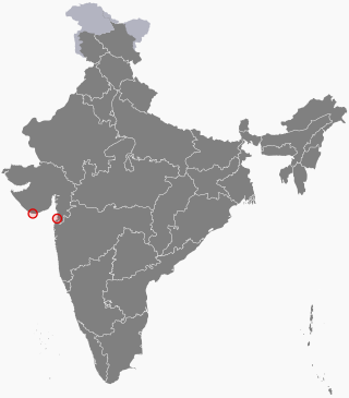
Dadra and Nagar Haveli and Daman and Diu is a union territory in India. The territory was constituted through the merger of the former territories of Dadra and Nagar Haveli and Daman and Diu. Plans for the proposed merger were announced by the Government of India in July 2019; the necessary legislation was passed in the Parliament of India in December 2019 and came into effect on 26 January 2020. The territory is made up of four separate geographical entities: Dadra, Nagar Haveli, Daman, and the island of Diu. All four areas were formerly part of Portuguese India, and had a joint capital at Panjim, Goa along with Goa. They came under Indian rule in the mid-20th century after the Annexation of Goa and of the Free Dadra and Nagar Haveli. Goa, Daman and Diu were jointly administered until 1987, when Goa was granted statehood after the Konkani language agitation. The current capital is Daman and Silvassa is the largest city.

The first case of the COVID-19 pandemic in India was reported on 30 January 2020, originating from China. Slowly, the pandemic spread to various states and union territories including the union territory of Dadra and Nagar Haveli and Daman and Diu. The first case was recorded in this region on 10 April 2020.

References

  1. Data from the CIA World Factbook Archived 12 August 2008 at the Wayback Machine . Map compiled in 2021, data from 2020.
  2. "5: Gender Composition of the Population" (PDF), Provisional Population Totals – India, pp. 78–96
  3. "1: Population" (PDF), Women and Men in India. Population related statistics., Ministry of Statistics and Programme Implementation
  4. 1 2 "National Family Health Survey (NFHS-4): India Fact Sheet" (PDF). rchiips.org. Ministry of Health and Family Welfare, Government of India. International Institute for Population Sciences, Mumbai. 2015–2016. Retrieved 10 September 2021.{{cite web}}: CS1 maint: others (link)
  5. UNPFA, Sex Ratio at Birth in India (2020), 3.
  6. UNPFA, Sex Ratio at Birth in India (2020), 5.
  7. 1 2 "Sex Ratio at Birth – India & Larger States". NITI Aayog . Archived from the original on 12 August 2021. Retrieved 8 September 2021.
  8. 1 2 Tripathi, Rahul (15 July 2019). "Survey shows sex ratio falling further to 896 in 3 years to 2017". The Economic Times. Retrieved 8 September 2021.
  9. 1 2 Bakshi, Roopa. "Declining sex-ratios – a matter of concern". UNICEF. Archived from the original on 14 September 2019. Retrieved 30 July 2018.
  10. "Update on Child Sex Ratio". Press Information Bureau. Ministry of Health and Family Welfare, Government of India. 17 December 2021. Retrieved 16 January 2023.{{cite web}}: CS1 maint: others (link)
  11. 1 2 "Handbook of Statistics on Indian States 2020. Social and Demographic Indicators. Table 5: State-wise Sex Ratio". Reserve Bank of India. 13 October 2020. Retrieved 9 September 2021.
  12. 1 2 "Decline In Child Sex Ratio". Press Information Bureau. Ministry of Health and Family Welfare, Government of India. 11 February 2014. Retrieved 9 September 2021.{{cite web}}: CS1 maint: others (link)
  13. "Statistical Year Book 2015" (PDF). telangana.gov.in. Directorate of Economics and Statistics, Government of Telangana. p. 3. Retrieved 10 September 2021. The sex ratio is defined as the number of females per 1,000 males. This ratio for the state is 988 according to 2011 Census.
Bibliography

Further reading