Waynoka is a city in Woods County, Oklahoma, United States. It is located on U.S. Highway 281 and State Highway 14, seventy miles west of Enid. The population, which peaked at 2018 in 1950, stood at 927 according to the 2010 census.

White Sands National Park is an American national park located in the state of New Mexico on U.S. Route 70 approximately 15 miles (24 km) southwest of Alamogordo and 52 miles (84 km) northeast of Las Cruces, in western Otero County and northeastern Doña Ana County. The park is situated at an average elevation of about 4,000 feet (1,219 m) in the Tularosa Basin and comprises the southern part of a 275 sq mi (710 km2) field of white sand dunes composed of gypsum crystals. The gypsum dunefield is the largest of its kind on Earth.

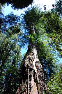
Muir Woods National Monument is a United States National Monument managed by the National Park Service, named after naturalist John Muir. It is located on Mount Tamalpais near the Pacific coast, in southwestern Marin County, California. It is part of the Golden Gate National Recreation Area, and is 12 miles (19 km) north of San Francisco. It protects 554 acres (224 ha), of which 240 acres (97 ha) are old growth coast redwood forests, one of a few such stands remaining in the San Francisco Bay Area.

Bruneau Dunes State Park is a public recreation and geologic preservation area featuring large sand dunes and small lakes, located northeast of Bruneau and fifteen miles (24 km) south of Mountain Home, Idaho. The state park is the site of North America's highest single-structured sand dune which is approximately 470 feet (140 m) high. The park encompasses 4,800 acres (1,900 ha) and features the Bruneau Dunes Observatory, where visitors can use a telescope for stargazing.

Great Sand Dunes National Park and Preserve is an American national park that conserves an area of large sand dunes up to 750 feet (229 m) tall on the eastern edge of the San Luis Valley, and an adjacent national preserve in the Sangre de Cristo Range, in south-central Colorado, United States. The park was originally designated Great Sand Dunes National Monument on March 17, 1932, by President Herbert Hoover. The original boundaries protected an area of 35,528 acres. A boundary change and redesignation as a national park and preserve was authorized on November 22, 2000, and then established by an act of Congress on September 24, 2004. The park encompasses 107,342 acres while the preserve protects an additional 41,686 acres for a total of 149,028 acres. The recreational visitor total was 527,546 in 2019.
Armstrong Redwoods State Natural Reserve is a state park of California in the United States established to preserve 805 acres (326 ha) of coast redwoods. The reserve is located in Sonoma County, just north of Guerneville.

Alabaster Caverns State Park is a 200-acre (0.81 km2) state park approximately 4.5 miles (7.2 km) south of Freedom, Oklahoma, United States near Oklahoma State Highway 50. The park attracted 24,706 visitors in FY 2016, The lowest count of the three parks in its part of Oklahoma. According to the Encyclopedia of Oklahoma History and Culture, the park Previously attracted about 40,000 visitors per year. It is home to the largest natural gypsum cave in the world that is open to the public. The gypsum is mostly in the form of alabaster. There are several types of alabaster found at the site, including pink, white, and the rare black alabaster. This black alabaster can be found in only three veins in the world, one each in Oklahoma, Italy and China. Another form of gypsum can be found in the many selenite crystal formations.
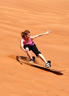
Sandboarding is a boardsport and extreme sport similar to snowboarding that involves riding across or down a sand dune while standing on a board, either with both feet strapped in or while standing loose, without bindings. Sandboarding can also be practised sitting down or lying on the belly or the back. It typically involves a sandboard, although it is also possible to use sleds, surfboards, a skateboard deck, or snowboards.

Grayton Beach State Park is a Florida State Park located between Panama City Beach and Destin, near the unincorporated area of Grayton Beach, on CR 30A, in northwestern Florida. Its sister park is Deer Lake State Park.

Warren Dunes State Park is a 1,952-acre (7.90 km2) Michigan state park, located along the eastern shore of Lake Michigan in Berrien County. The park's large sand dunes and lakeshore beaches make it one of the most popular of Michigan’s state parks with an average of about one million visitors annually.

Assateague Island National Seashore is a unit of the National Park Service system of the U.S. Department of the Interior. Located on the East Coast along the Atlantic Ocean in Maryland and Virginia, Assateague Island is the largest natural barrier island ecosystem in the Middle Atlantic states region that remains predominantly unaffected by human development. Located within a three-hour drive to the east and south of Richmond, Washington, Baltimore, Wilmington, Philadelphia major metropolitan areas plus north of the several clustered smaller cities around Hampton Roads harbor of Virginia with Newport News, Hampton, Norfolk, Portsmouth, Chesapeake and Virginia Beach. The National Seashore offers a setting in which to experience a dynamic barrier island and to pursue a multitude of recreational opportunities. The stated mission of the park is to preserve and protect “unique coastal resources and the natural ecosystem conditions and processes upon which they depend, provide high-quality resource-based recreational opportunities compatible with resource protection and educate the public as to the values and significance of the area”.

Tettegouche State Park, pronounced “tet-a-gooch”, in the United States, is a Minnesota state park on the north shore of Lake Superior 58 miles (93 km) northeast of Duluth in Lake County on scenic Minnesota Highway 61. The park's name stems from the Tettegouche Club, an association of local businessmen which purchased the park in 1910 from the Alger-Smith Lumber Company. The club's members protected the area until its sale in 1971 to the deLaittres family. In 1979, the state of Minnesota acquired 3,400 acres (1,400 ha) from the Nature Conservancy, including Tettegouche Camp. The land was added to Baptism River State Park, which was renamed Tettegouche State Park.

Guadalupe-Nipomo Dunes is the largest remaining dune system south of San Francisco and the second largest in the U.S. state of California. It encompasses an 18-mile (29 km) stretch of coastline on the Central Coast of California and extends from southern San Luis Obispo County to northern Santa Barbara County.

The Grand Canyon Skywalk is a horseshoe-shaped cantilever bridge with a glass walkway at Eagle Point in Arizona near the Colorado River on the edge of a side canyon in the Grand Canyon West area of the main canyon. USGS topographic maps show the elevation at the Skywalk's location as 4,770 ft (1,450 m) and the elevation of the Colorado River in the base of the canyon as 1,160 ft (350 m), and they show that the height of the precisely vertical drop directly under the skywalk is between 500 ft (150 m) and 800 ft (240 m). In 2015 the attraction passed one million visitors.

Big Bay State Park is a state park of Wisconsin, United States, on Madeline Island, the largest of 22 Apostle Islands in Lake Superior. The 2,350-acre (951 ha) park has picturesque sandstone bluffs and caves and a 1.5-mile-long (2.4 km) sand beach. It encloses unique habitat types including lakeside dunes, sphagnum bogs, and old-growth forest. Bald eagles return annually to the park to nest and rear offspring.

The Little Sahara Recreation Area is a large area of sand dunes, hills and sagebrush flats located in the northeast corner of the Sevier Desert in Juab County in the west central part of Utah, United States.

Jockey's Ridge State Park is a North Carolina state park in Dare County, North Carolina in the United States. Located in Nags Head, North Carolina, it covers a 427-acre (1.73 km2) area, and includes the tallest active sand dune system in the eastern United States. It is the most visited park within the NC park system. The park is a day-use only park and has no campgrounds. Jockey's Ridge contains three unique ecosystems: the Roanoke Sound, the dune system, and the maritime forest. Often when it rains, water collects near the bottom of the dunes creating temporary ponds known as vernal pools. Few fauna can be seen around the dunes, although some types of flora, such as tall grass, may be seen near the bottom of the dunes.

Kathryn Abbey Hanna Park is a 1.5-mile (2.4 km) public beach and city park in Jacksonville, Florida. It is located at Mayport in the Jacksonville Beaches area. It consists of 447 acres (1.81 km2) of mature coastal hammock, which is increasingly rare along Florida's heavily developed Atlantic coast.
Bull Gap is a 60-acre (240,000 m2) hill climb area located in Michigan and links over 115 miles (185 km) of trails for legal off-road vehicle (ORV) use.
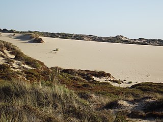
The Cresmina Dune extends over 66 hectares and is a part of the Guincho-Oitavos dune system, located on the edge of the Sintra-Cascais Natural Park near Cascais in Portugal. This dune system is considered fairly unique because, as a result of the prevailing northwest winds, the sand from the Guincho and Cresmina beaches eventually returns to the sea 5km further to the south near Guia, after migrating over the flat, rocky and largely uninhabited area of Cabo Raso.