
Sumatra is one of the Sunda Islands of western Indonesia. It is the largest island that is fully within Indonesian territory, as well as the sixth-largest island in the world at 475,807.63 km2 (182,812 mi.2), including adjacent islands such as the Simeulue, Nias, Mentawai, Enggano, Riau Islands, Bangka Belitung and Krakatoa archipelago.

Lampung, officially the Province of Lampung, is a province of Indonesia. It is located on the southern tip of the island of Sumatra. It has a short border with the province of Bengkulu to the northwest, and a longer border with the province of South Sumatra to the north, as well a maritime border with the province of Banten and Jakarta to the east. It is the original home of the Lampung people, who speak their own language, and possess their own written script. Its capital is Bandar Lampung.

Bengkulu, historically known as Bencoolen, is a province of Indonesia. It is located on the southwest coast of Sumatra. It was formed on 18 November 1968 by separating out the area of the historic Bencoolen Residency from the province of South Sumatra under Law No. 9 of 1967 and was finalized by Government Regulation No. 20 of 1968. Spread over 20,130.21 km2, it is bordered by the provinces of West Sumatra to the north, Jambi to the northeast, Lampung to the southeast, and South Sumatra to the east, and by the Indian Ocean to the northwest, south, southwest, and west.

Suoh or Suwoh is an 8 × 16 km wide volcano-tectonic depression in the southern part of Sumatra, Indonesia. Historical maars and silicic lava domes are found along the Great Sumatran fault line. Phreatic eruptions occurred during the major 1933 Liwa earthquake, West Lampung Regency, Lampung Province
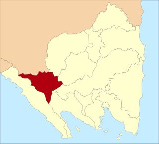
West Lampung Regency is a regency of Lampung Province, Sumatra, Indonesia. Until 2012 it had an area of 4,950.4 km2 of which forests occupied some 57% of the total area. It had a population of 418,560 people at the 2010 census. However, on 25 October 2012 the southwestern part of this area was separated from West Lampung Regency to form the new Pesisir Barat Regency.

North Lampung Regency is an inland regency (kabupaten) of Lampung Province, Sumatra, in Indonesia. It has an area of 2,725.63 km2 and had a population of 583,925 at the 2010 census and 633,099 at the 2020 census; the official estimate as at mid 2022 was 635,129. The regency seat is the town of Kotabumi.
Pringsewu Regency is a regency of Lampung Province, Sumatra, Indonesia. It has an area of 625 km² and had a population of 364,825 people at the 2010 Census and 405,466 at the 2020 Census; the official estimate as at mid 2022 was 408,415. The regency seat is the town of Pringsewu, located 37 kilometres from the provincial capital of Bandar Lampung. The regency was created on 29 October 2008 from the former eastern part of Tanggamus Regency.

Tanggamus Regency is a regency (kabupaten) of Lampung Province, Sumatra, Indonesia. It has an area of 4,654.96 km² and had a population of 534,595 at the 2010 Census and 640,275 at the 2020 Census; the official estimate as at mid 2022 was 652,898. The regency seat is the town of Kota Agung Pusat. The regency was created on 21 March 1997, but districts in its eastern part were split away on 29 October 2008 to form a new Pringsewu Regency. It lies in the southwest of the province, and surrounds Semangka Bay on its west, north and east coasts.

Tulang Bawang Regency is a regency (kabupaten) of Lampung Province, Sumatra, Indonesia. The regency was created on 3 January 1997 from the eastern half of North Lampung Regency; when created, it originally covered a much wider area, but on 29 October 2008 the 7 northern districts were separated off to form a new Mesuji Regency, and the 8 western districts were also separated off to form a new West Tulang Bawang Regency. It now has an area of 3,466.32 square kilometres (1,338.35 sq mi) and had a population of 397,906 at the 2010 Census and 430,021 at the 2020 Census; the official estimate as at mid 2022 was 431,208. The regency seat is the town of Menggala, located about 120 kilometres (75 mi) from the provincial capital of Bandar Lampung. The regency takes its name from the Tulang Bawang River which flows through the province.

Pesisir Barat Regency is a regency in Lampung Province of Indonesia. It was created on 25 October 2012 from the eight western districts of West Lampung Regency. It covers an area of 2,907.23 km2, and had a population of 141,741 at the 2010 Census and 162,697 at the 2020 Census; the official estimate as of mid-2022 was 164,816. The administrative center is the town of Krui. The majority group in the Pesisir Barat Regency is the Lampung people.

The Lampung or Lampungese are an indigenous ethnic group native to Lampung and some parts of South Sumatra, Bengkulu, as well as in the southwest coast of Banten. They speak the Lampung language, a Lampungic language estimated to have 1.5 million speakers.
Baitul Mukhlisin Islamic Center Mosque is a mosque located in Liwa, West Lampung Regency, Lampung, Indonesia. The mosque is constructed in 2009 and finished in 2010. It is known as Bintang Emas Mosque as the star on top of the dome is coated in gold color. Most of the buildings use architecture with Arabic ornaments. Building materials are selected from Lampung and andesite marble stones that enhance space and minimize maintenance costs.
This is a list of emblems or coat of arms used in Indonesia. Indonesia is divided into 38 provinces, and each province is divided into regencies (kabupaten) and cities (kota). There are 416 regencies and 98 cities. Each province, regency, and city has its own emblem.
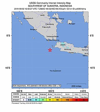
The 2019 Sunda Strait earthquake occurred on the night of 2 August 2019, when a magnitude 6.9 earthquake rattled Sunda Strait at a moderate depth of 52.8 kilometres. The epicentre was located 214 km from Bandar Lampung, the capital of Lampung and 147 km west of Sumur, Pandeglang Regency. The earthquake struck with a maximum intensity of VI (Strong). The earthquake prompted a tsunami warning in the area, with authorities urging coastal residents to immediately evacuate to higher grounds.
Cape Belimbing, is a remote cape located in Bangkunat subdistrict, Pesisir Barat Regency, Lampung, Indonesia. The cape is the southernmost point of Sumatra, facing the Sunda Strait to the southeast and Indian Ocean to the west. The cape is part of Bukit Barisan Selatan National Park, one of national parks located in Sumatra. There is a lighthouse just northwest from the cape. The surrounding waters around the cape is frequently patrolled by the Indonesian Navy to preserve coral reefs sustainability from human destruction.
The Kerajaan Jambu Lipo or Kingdom of Jambu Lipo is located in the district of Lubuk Tarok, Sijunjung district, West Sumatra now. According to Tambo Minangkabau, the name Jambu Lipo came from the result of an agreement between Rajo Tigo Selo in Pagaruyung which should not forget each other, with the origin of the word "jan bu lupo" which means "don't forget mother".

On 25 February 2022 at 08:39 WIB, a moment magnitude (Mw ) 6.2 earthquake struck West Sumatra, Indonesia at a depth of 4.0 km (2.5 mi). Preceded by one foreshock and followed by over 200 aftershocks, the mainshock had an epicenter at the foot of Mount Talakmau in Pasaman Regency. The mainshock was the result of strike-slip faulting along a previously unidentified segment of the Great Sumatran Fault. At least 27 people died, 457 were injured, and 19,221 others were displaced. It inflicted 780 million Indonesian rupiahs (Rp) worth of damage. The heaviest damage was recorded at three villages around Mount Talakmau. Landslides and flash floods caused additional damage and casualties.
The 1933 Sumatra earthquake or Liwa earthquake occurred in West Lampung Regency, Lampung Province, Indonesia on June 25. The earthquake had an estimated surface-wave magnitude (Ms ) of 7.7 occurring at a shallow depth of 20 km. It had an epicenter onshore, devastating the city of Liwa. At least 76 people were reported killed, although the death toll may have been in the thousands. Aftershocks followed, including one which was strong enough to cause additional fatalities. The mainshock also triggered a nearby volcanic eruption two weeks later, killing some people.

The Komering are an ethnic group that inhabits along the Komering River in South Sumatra province.

