Llandaff Fields

Last updated

Llandaff Fields Llandaff Fields path.JPG
Llandaff Fields

Llandaff Fields is a large parkland spanning parts of central and northern Cardiff, Wales.

Contents

The park is owned by Cardiff Council and managed by its Parks department. The parkland is highly visible and accessed from local communities. The parkland is lined with avenues of trees and large grassed areas. The park is also used for sporting events. [1]

History

Llandaff Fields were purchased for Cardiff Council from the mill-owning Thompson Family in 1898. The park is located on a historically important route between the city centre and Llandaff. [2]

In 1860, an extension of the park northwards for athletic purposes was announced, and took place in 1879, merging with Pontcanna Fields. Development of the park took place between 1899 and 1901. Three cricket pitches, a hockey pitch and a tennis court were added. Plans were submitted for a swimming pool, which closed early 1990s. Features such as a fountain pool, rockery and fern dell were mentioned in the 70-acre (280,000 m2) area in a gardening magazine in 1923, but have since gone. 40 acres (160,000 m2) of the fields were used for allotments during the war. [3]

The 2008 National Eisteddfod was held on Llandaff Fields, the consequence of which was still a problem in April 2010 after a part of the fields remained waterlogged. Cardiff Council has since announced £400,000 redevelopment plans for the pitches with under-soil drains. [4]

In July 2010 Cardiff Council rejected an application for a car park outside the University of Wales Institute, Cardiff, citing that it would harm the character and appearance of the Llandaff Conservation Area, result in the loss of open space in the city, and worsen traffic congestion on Western Avenue. [5]

Landscape

Llandaff Fields with skyscrapers of the city centre in the background Llandaff Fields rugby.JPG
Llandaff Fields with skyscrapers of the city centre in the background

The park is made up of a mixture of vast mown grass land and woodland areas home to wildlife. The park is situated in the valley of the River Taff. Mature trees are frequent throughout the park, such as the Horse Chestnut and Lime trees [2]

The park is an area of mown grass crossed by a network of tarmac walks, bounded by roads on all sides but the east, where most recreational facilities are found. [3]

Location

The fields, together with the adjacent Pontcanna Fields, form a large wedge of open space, situated on the west bank of the River Taff, stretching from the city centre out to the west of Llandaff. Sophia Gardens lies just to the south of the area and Bute Park is located on the other side of the river. [3]

Access by foot to the park is from the surrounding streets in the respective communities. The Taff Trail cycle route runs through the nearby Pontcanna Fields, just to the north of Llandaff Fields. Bus services run along Cathedral Road and Cardiff Road, to the south and east of the park. [2]

WJEC's headquarters and the University of Wales Institute Cardiff's Llandaff campus are located just beyond the northern boundary of the fields.

Facilities

The park has sport pitches designed for many different sports, as well as tennis courts and bowls facilities, and a playground. Llandaff Fields Tennis Club is based in the park. [6] Changing rooms, toilets and parking are provided at Llandaff Fields. [2]

Related Research Articles

<span class="mw-page-title-main">Llanishen</span> District and community in Cardiff, Wales

Llanishen is a district and community in the north of Cardiff, Wales. Its population as of the 2011 census was 17,417.

<span class="mw-page-title-main">Cathays</span> District and community in Cardiff, Wales

Cathays is a district and community in the centre of Cardiff, capital of Wales. It is an old suburb of Cardiff established in 1875. It is densely populated and contains many Victorian terraced houses. The area falls into the Cathays ward. It is the third most populous community in Cardiff, having a population of 18,002 in 2011.

<span class="mw-page-title-main">Radyr</span> Suburb of Cardiff, Wales

Radyr (Welsh: Radur is an outer suburb of Cardiff, about 4 miles northwest of Cardiff city centre. Radyr is part of Radyr and Morganstown Community, for which the 2011 Census recorded a population of 6,417.

<span class="mw-page-title-main">Heath, Cardiff</span> District and community in Cardiff, Wales

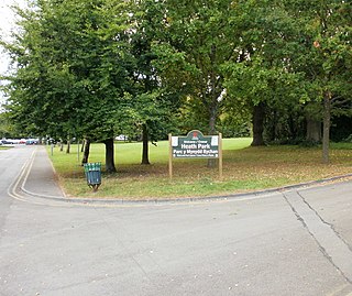
Heath is a district, community and coterminous electoral ward in the north of Cardiff, capital of Wales. It is a predominantly affluent area with property prices being the third highest in the city. The area is known for its traditional 1930s detached and semi-detached properties with large south facing gardens. Roads are tree lined and large greeneries with the notable attraction of Heath Park and the joining of the University Hospital of Wales.

<span class="mw-page-title-main">Gabalfa</span> District and community of Cardiff, Wales

Gabalfa is a district and community in the north of the city of Cardiff, capital of Wales. It is characterised by a four-lane flyover road at the Gabalfa Interchange, where the A48 road meets the A470 road which leads from Cardiff to northern Wales, and the A469 road.

<span class="mw-page-title-main">Pontcanna</span> District and community in Cardiff, Wales

Pontcanna is an inner-city district and community in the west of Cardiff, Wales. It is located adjecent to Canton, Cardiff. It is also located a short distance to the city centre, and its borders are approximately indicated by Western Avenue, the River Taff, Cowbridge Road East and Llandaff Road.

<span class="mw-page-title-main">Taff Trail</span> Walking and cycling track in South Wales

The Taff Trail is a popular walking and cycle path that runs for 55 miles (89 km) between Cardiff Bay and Brecon in Wales. It is so named because it follows the course of the River Taff. Along much of its length, it follows the National Cycle Network Route 8 that continues to Holyhead, and is substantially off-road.

<span class="mw-page-title-main">River Taff</span> River in Wales which flows into Cardiff Bay

The River Taff is a river in Wales. It rises as two rivers in the Brecon Beacons; the Taf Fechan and the Taf Fawr before becoming one just north of Merthyr Tydfil. Its confluence with the River Severn estuary is in Cardiff.

<span class="mw-page-title-main">Riverside, Cardiff</span> District and community in Cardiff, Wales

Riverside is an inner-city area and community of Cardiff, Wales, next to the River Taff. Riverside is also the name of the electoral ward, which includes the district of Pontcanna, to the north. The population of the community in 2011 was 13,771. Pontcanna was removed from the community in 2016.

<span class="mw-page-title-main">Bute Park</span> Landscaped garden and parkland in Cardiff, Wales

Bute Park and Arboretum is a park in Cardiff, Wales. It comprises 130 acres (53 ha) of landscaped gardens and parkland that once formed the grounds of Cardiff Castle. The park is named after the 3rd Marquess of Bute, whose family owned the castle.

<span class="mw-page-title-main">Canton, Cardiff</span> District and community in Cardiff, Wales

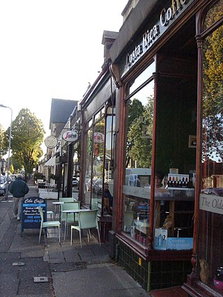
Canton is an inner-city district and community in the west of Cardiff, capital of Wales, lying 2 miles (3.2 km) west of the city's civic centre. It is located adjecent to Pontcanna, Cardiff. Canton is one of the most ethnically diverse of Cardiff's suburbs, with a significant Pakistani and Indian population. The total population of Canton increased to 14,304 at the 2011 census. It is also the most Welsh-speaking district of central Cardiff, with 19.1% of the population speaking Welsh.

<span class="mw-page-title-main">Llandaff North</span> District and community of Cardiff, Wales

Llandaff North, is a district, community and coterminous electoral ward in the north of Cardiff, the capital city of Wales.

<span class="mw-page-title-main">Victoria Park, Cardiff</span> Park in Cardiff, Wales

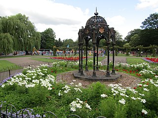
Victoria Park is a public park in the Canton district of Cardiff in south Wales at Cowbridge Road East.

<span class="mw-page-title-main">Fairwater, Cardiff</span> District and community in Cardiff, Wales

Fairwater is a district and community in the west of Cardiff, capital of Wales. It is located a few miles from Culverhouse Cross which connects Cardiff to the M4 motorway. The population taken at the 2011 census was 12,981.

<span class="mw-page-title-main">Sophia Gardens</span> Park in Cardiff, Wales

Sophia Gardens is a public park in Riverside, Cardiff, Wales, on the west bank of the River Taff. International test cricket matches and county cricket matches are held in the Sophia Gardens cricket ground, the home of Glamorgan County Cricket Club. The gardens are listed on the Cadw/ICOMOS Register of Parks and Gardens of Special Historic Interest in Wales.

<span class="mw-page-title-main">Sport in Cardiff</span> Overview of sport in the capital city of Wales

Sport in Cardiff is dictated by, amongst other things, its position as the capital city of Wales, meaning that national home sporting fixtures are nearly always played in the city. All of Wales' multi-sports agencies and many of the country's sports governing bodies have their headquarters in Cardiff and the city's many top-quality venues have attracted world-famous sport events, sometimes unrelated to Cardiff or to Wales.

<span class="mw-page-title-main">Cycling in Cardiff</span> Transport by bicycle in Cardiff, Wales

Cycling in Cardiff, capital of Wales, is facilitated by its easy gradients and large parks. In the mid-2000s between 2.7% and 4.3% of people commuted to work by cycling in the city. In 2017 12.4% of workers cycled to work at least 5 days a week. However, cyclists in the city are deterred from cycling by poor facilities and aggressive traffic, according to research by Cardiff University.

<span class="mw-page-title-main">Cardiff Bridge</span> Grade II listed building in Cardiff

Cardiff Bridge is the road bridge crossing the River Taff at the approximate site of the original river crossing, close to Cardiff Castle in the centre of Cardiff, Wales.

<span class="mw-page-title-main">Riverside (Cardiff electoral ward)</span> Electoral ward in Wales

The Riverside electoral ward of Cardiff covers the Riverside and Pontcanna areas of the city, electing three councillors to Cardiff Council. The ward was originally created in 1890, as a ward to Cardiff County Borough Council.

References

  1. Cardiff Council: Llandaff Fields Archived 2011-06-09 at the Wayback Machine
  2. 1 2 3 4 Cardiff Council: Countryside on your doorstep - Llandaff Fields [ permanent dead link ]
  3. 1 2 3 Pontcanna Fields and Llandaff Fields (pdf) Archived 2014-04-07 at the Wayback Machine , Coflein.gov.uk.
  4. "No, it’s not a lake, it’s Llandaff Fields!", Wales Online, 3 April 2010. Retrieved 2015-12-11.
  5. GuardianCardiff | Llandaff Fields car park refused
  6. "Llandaff Fields Tennis Club". Archived from the original on 12 September 2012.

51°29′26″N3°12′27″W / 51.4906°N 3.2074°W / 51.4906; -3.2074