Lobito

Last updated
Lobito
Camara Municipal Lobito (19626476942) (cropped).jpg
Igreja da Arrabida in Lobito - Angola 2015 (cropped).jpg
Restinga Peninsula (18996958243) (cropped).jpg
Hotel in Lobito.JPG
Mercado Municipal de Lobito 2 (cropped).jpg
Bandeira do Lobito.png
Brasao do Lobito.png
Angola location map.svg
Red pog.svg
Lobito
Location in Angola
Coordinates: 12°22′S13°32′E / 12.367°S 13.533°E / -12.367; 13.533
CountryFlag of Angola.svg  Angola
Province Benguela Province
Incorporated1843
Area
   Municipality 554 km2 (214 sq mi)
Elevation
139 m (456 ft)
Population
 (2014 Census) [1]
   Municipality 393,079
  Density710/km2 (1,800/sq mi)
   Urban
[2]
357,950
Time zone UTC+1 (WAT)
Climate BWh

Lobito is a municipality in Angola. It is located in Benguela Province, on the Atlantic Coast north of the Catumbela Estuary. The Lobito municipality had a population of 393,079 in 2014. [1]

Contents

History

Coat of arms of during the Portuguese colonial period. Lobito.thumb.jpg
Coat of arms of during the Portuguese colonial period.

The city was founded in 1843 and owes its existence to the bay of the same name having been chosen as the sea terminus of the Benguela railway to the far interior, passing through Luau to Katanga in the Democratic Republic of the Congo. [3] The city is located on the coast of the Atlantic Ocean. The population of the municipality is 393,079 (2014) in an area of 3,648 km². [4] The municipality consists of the communes Canjala, Egipto Praia and Lobito.

Portuguese rule

Lobito, was built on a sandspit and reclaimed land, with one of Africa's finest natural harbours, protected by a 5 km long sandspit. The old municipality ( concelho ) was created in 1843 by the Portuguese administration. The town was also founded in 1843 by order of Maria II of Portugal, and its harbour works were begun in 1903.

It wasn't until 1843 that Maria II of Portugal approved the foundation of the town, which had by then been known as Catumbela das Ostras (Catumbela of Oysters) [5]

Lobito coast. Lobito restinga2.jpg
Lobito coast.

Large developments, however, were not stimulated until the completion in 1928 of the important Benguela Railway, which connected Portuguese Angola with the Belgian Congo.

Under Portuguese rule, the port was one of Angola's busiest, and the busiest of Africa, exporting agricultural produce from the interior and handling transit trade from the mines of southeastern Belgian Congo and of Northern Rhodesia. Fishing, tourism and services were also important. The carnival in Lobito was also one of the most renowned and popular in Portuguese Angola. [6]

Post-independence

After the April 25, 1974 Carnation Revolution in Lisbon, Angola was offered independence. Lobito's port activities were highly limited by disruptions to railway transit and high insecurity during the Angolan Civil War (1975–2002). With peace and stability, in the 2000s, Lobito started the process of reconstruction and resumed its path to development.

Climate

Lobito experiences a mild tropical arid climate with few temperature extremes. The winters are extremely dry and warm, while summers are relatively wet and hotter.

Climate data for Lobito
MonthJanFebMarAprMayJunJulAugSepOctNovDecYear
Record high °C (°F)35.0
(95.0)
35.0
(95.0)
34.4
(93.9)
35.6
(96.1)
33.3
(91.9)
33.3
(91.9)
28.9
(84.0)
29.4
(84.9)
28.3
(82.9)
30.6
(87.1)
33.9
(93.0)
32.8
(91.0)
35.6
(96.1)
Mean daily maximum °C (°F)28.3
(82.9)
29.4
(84.9)
30.6
(87.1)
30.0
(86.0)
28.3
(82.9)
25.6
(78.1)
23.3
(73.9)
23.3
(73.9)
24.4
(75.9)
26.1
(79.0)
28.3
(82.9)
28.3
(82.9)
27.2
(81.0)
Daily mean °C (°F)25.3
(77.5)
26.4
(79.5)
27.2
(81.0)
27.0
(80.6)
25.0
(77.0)
22.2
(72.0)
20.3
(68.5)
20.0
(68.0)
21.4
(70.5)
23.3
(73.9)
25.3
(77.5)
25.3
(77.5)
24.1
(75.4)
Mean daily minimum °C (°F)22.2
(72.0)
23.3
(73.9)
23.9
(75.0)
23.9
(75.0)
21.6
(70.9)
18.9
(66.0)
17.2
(63.0)
16.7
(62.1)
18.3
(64.9)
20.6
(69.1)
22.2
(72.0)
22.2
(72.0)
20.9
(69.6)
Record low °C (°F)13.3
(55.9)
16.1
(61.0)
18.9
(66.0)
18.3
(64.9)
13.9
(57.0)
12.8
(55.0)
10.6
(51.1)
11.7
(53.1)
12.8
(55.0)
13.9
(57.0)
16.1
(61.0)
17.2
(63.0)
10.6
(51.1)
Average precipitation mm (inches)20.3
(0.80)
38.1
(1.50)
119.4
(4.70)
53.3
(2.10)
2.5
(0.10)
0.0
(0.0)
0.0
(0.0)
1.3
(0.05)
2.5
(0.10)
30.5
(1.20)
25.4
(1.00)
61.0
(2.40)
354.0
(13.94)
Source: Sistema de Clasificación Bioclimática Mundial [7]

Transportation

Port of Lobito. Porto do Lobito - Angola 2015 (cropped).jpg
Port of Lobito.

Lobito is the terminus of the Benguela Railway

Port

The Port of Lobito is located in Lobito Bay on a sandspit approximately 4.8 km long. The port is administered by the Empresa Portuaria do Lobito. The Port of Lobito handles 2,000,000 tonnes of cargo and 370 ships annually, and along with economic development in the Benguala region, port facilities are under expansion. [8]

Airports

Lobito does not have its own airport. The city is located 13 kilometres (8.1 mi) from Catumbela Airport and 33 kilometres (21 mi) from Benguela Airport. [8]

International Relations

Lobito is twinned with:

Related Research Articles

Transport in Angola comprises:

This article is about the Transport in Zambia.

<span class="mw-page-title-main">Matadi</span> Provincial capital and city in Kongo Central, Democratic Republic of the Congo

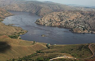
Matadi is the chief sea port of the Democratic Republic of the Congo and the capital of the Kongo Central province, adjacent to the border with Angola. It had a population of 245,862 (2004). Matadi is situated on the left bank of the Congo River, 148 km (92 mi) from the mouth and 8 km (5.0 mi) below the last navigable point before the rapids that make the river impassable for a long stretch upriver.

<span class="mw-page-title-main">Benguela Province</span> Province of Angola

Benguela is a province of Angola, situated in the west of the country. It lies on the Atlantic Ocean, and borders the provinces of Cuanza Sul, Namibe, Huila, and Huambo. The province has an area of 39,826 square kilometres (15,377 sq mi) and its capital is Benguela. According to the 2014 census, there were 2,231,385 inhabitants in the province. The current governor of Benguela is Isaac dos Anjos.

<span class="mw-page-title-main">Huambo</span> Municipality in Angola

Huambo, formerly Nova Lisboa, is the third-most populous city in Angola, after the capital city Luanda and Lubango, with a population of 595,304 in the city and a population of 713,134 in the municipality of Huambo. The city is the capital of the province of Huambo and is located about 220 km E from Benguela and 600 km SE from Luanda. Huambo is a main hub on the Caminho de Ferro de Benguela (CFB), which runs from the port of Lobito to the Democratic Republic of the Congo's southernmost province, Katanga. Huambo is served by the Albano Machado Airport.

<span class="mw-page-title-main">Moçâmedes</span> Municipality in Namibe Province, Angola

Moçâmedes is a city in southwestern Angola, capital of Namibe Province. The city's current population is 255,000. Founded in 1840 by the Portuguese colonial administration, the city was named Namibe between 1985 and 2016. Moçâmedes has a cool dry climate and desert vegetation, because it is near the Namib Desert.

<span class="mw-page-title-main">Benguela</span> Municipality in Benguela Province, Angola

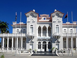
Benguela is a city in western Angola, capital of Benguela Province. Benguela is one of Angola's most populous cities with a population of 555,124 in the city and 561,775 in the municipality, at the 2014 census.

<span class="mw-page-title-main">Benguela railway</span> Railway line in Angola

The Benguela Railway is a Cape gauge railway line that runs through Angola from west to east, being the largest and most important railway line in the country. It also connects to Tenke in the Democratic Republic of the Congo (DRC), and to the Cape to Cairo Railway.

Luau is a town and municipality in Angola in the province of Moxico on the border with the Democratic Republic of Congo.

<span class="mw-page-title-main">Rail transport in the Democratic Republic of the Congo</span> Overview of rail transport in the Democratic Republic of the Congo

Rail transport is provided in the Democratic Republic of the Congo by the Société Nationale des Chemins de Fer du Congo (SNCC), the Société commerciale des transports et des ports (SCTP) (previously Office National des Transports until 2011), and the Office des Chemins de fer des Ueles (CFU).

<span class="mw-page-title-main">Catumbela</span> Municipality and town in Benguela Province, Angola

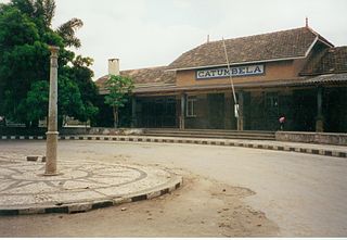
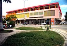
Catumbela is a city and municipality of the Benguela province in Angola. The municipality had a population of 175,805 in 2014.

<span class="mw-page-title-main">Beira–Lobito Highway</span> Road in Africa

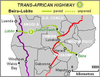
The Beira–Lobito Highway or TAH 9 is Trans-African Highway 9 in the transcontinental road network being developed by the United Nations Economic Commission for Africa (UNECA), the African Development Bank (ADB), and the African Union. The route has a length of 3,523 km (2,189 mi) crossing Angola, the most southerly part of the Democratic Republic of the Congo, Zambia, Zimbabwe, and central Mozambique.

Bocoio is a town and municipality in Benguela Province in Angola. Its administrative capital is Tchissandji. The municipality had a population of 164,685 in 2014.

<span class="mw-page-title-main">Railway stations in Angola</span>

Railway stations in Angola include:

<span class="mw-page-title-main">History of rail transport in Angola</span> History of rail transport in Angola

The history of rail transport in Angola began during the nineteenth century, when Angola was a colony of Portugal. It has involved the construction, operation and destruction of four separate, unconnected, coast-to-inland systems, in two different gauges. Operations on three of those systems have been largely restored; the other system has been closed.

<span class="mw-page-title-main">Cuca (beer)</span> Angolan beer brand

Cuca is a brand of beer manufactured by Companhia União de Cervejas de Angola in Angola.

<span class="mw-page-title-main">Catumbela River</span> River in central Angola

The Catumbela is a river in central Angola. The river mouth is at the Catumbela Estuary on the Atlantic Ocean at Catumbela, between Lobito and Benguela, and 240 kilometres (150 mi) from where it rises in the hills of Cassoco. The Catumbela supplies water to the city of Lobito. The mouth of the Catumbela was noted as a green vegetated region surrounded by barren land along the coast and a couple miles inland where it cuts a gorge through bare mountains. Alternate spellings are Catumbella and Cata-Bella.

<span class="mw-page-title-main">4 de Abril Bridge</span> Bridge

Catumbela Bridge is a bridge over the Catumbela River, located in the municipality of Catumbela, Angola. The bridge, which was inaugurated on 10 September 2009, by the President of the Republic of Angola, José Eduardo dos Santos, connects the cities of Benguela and Lobito, in addition to other provinces of the country.

The following is a timeline of the history of the city of Benguela, Angola.

<span class="mw-page-title-main">Empresa do Caminho de Ferro de Benguela-E.P.</span> State owned Angolan railway company

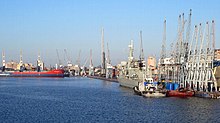
The Empresa do Caminho de Ferro de Benguela-E.P. is an Angolan state-owned company responsible for the administration of the Angolan stretch of the Benguela Railway. The company's headquarters are in the city of Lobito.

References

  1. 1 2 "Resultados Definitivos Recenseamento Geral da População e Habitação – 2014 Província de Benguela" (PDF). Instituto Nacional de Estatística, República de Angola. Archived from the original (PDF) on 1 November 2020. Retrieved 3 May 2020.
  2. Citypopulation.de Population of the major cities in Angola
  3. W. Martin James, Historical Dictionary of Angola, Rowman & Littlefield, USA, 2018, p. 208
  4. Census 2014 Archived 2016-03-04 at the Wayback Machine , preliminary results
  5. "Lobito - A cidade dos flamingos" (in Portuguese). destinobenguela.com. Retrieved 22 Mar 2016.
  6. LobitoAnosOuro.wmv, a film of the Lobito in Portuguese Angola, before independence from Portugal
  7. "Lobito (Angola)" (PDF). Centro de Investigaciones Fitosociológicas. Retrieved February 6, 2016.
  8. 1 2 IHS Fairplay Ports & Terminals Guide. Berkshire, UK: IHS Global Limited. 2013. pp. 1-42–1-43. ISBN   9781906313562.