
London Stone is the name given to a number of boundary stones that stand beside the rivers Thames and Medway, which formerly marked the limits of jurisdiction (riparian water rights) of the City of London.
London Stone is the name given to a number of boundary stones that stand beside the rivers Thames and Medway, which formerly marked the limits of jurisdiction (riparian water rights) of the City of London.

Until 1350, the English Crown held the right to fish the rivers of England and charged duties on those people it licensed to fish. In 1197 King Richard I, in need of money to finance his involvement in the Third Crusade, sold the rights over the lower reaches of the River Thames to the City of London. Marker stones were erected to indicate the limit of the City's rights. [1]
In Victorian times, the Lord Mayor would come in procession by water and touch the Staines stone with a sword to re-affirm the City's rights.
Control of the river passed from the City to the Thames Conservancy, and then below Teddington to the Port of London Authority and above it to Thames Water Authority and finally the Environment Agency.
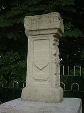
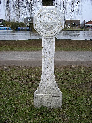
In medieval times before the canalisation of the Thames, Staines, was the highest point at which the high tide was perceivable for a few minutes every semi-diurnal tide (twice a day), adding some millimetres to the water depth compared to more upstream parishes. This London Stone marked the upstream limit of the City's rights. The official role of a Corporation of London stone of 1285 beside Staines Bridge was set out with a grant of associated privileges in a charter of Edward I. [2] Its use by the river is indicated by the indentations (on the right-hand face in the photo), caused by tow ropes of horse-drawn boats rubbing against the stone.
Staines is on the point where the north bank moves from east to north and has always been its site but the exact position has changed.
The stone has been recarved in its lower section making its long base narrower than its top. Its sole inscription is a very eroded etching 'STANE' in its top section of uncertain date, the Old English word for Stone (as in Stane Street). If the inscription is old enough this reinforces the traditional spelling, if not the pronunciation (as with Stane Street) of the name of the town, for which see Great Vowel Shift. It is possible that there was more than one such stone, explaining the Anglo Saxon name of the town, which was established many centuries after the Romans noted they called their staging post at the bridge, Ad Pontes. The lower carved area has a shield in relief as is its motif section below with eroded inscriptions. It stands on a much wider plinth inscribed with the names of various City worthies who may have been involved in its 1750 move.
The replica, due to its location, is in the lowest category of architecture, a Grade II listed structure partly achieved since it happens to stand on the point of one of the former coal-tax posts. [5] Martin Nail included the Stone as No. 83 in his list of London boundary marks. [6]

The historic downstream limit of the City's rights is about 33.5 miles (54 km) as the crow flies from London Bridge and is marked on both banks of the Thames: by the Crow Stone to the north and by the London Stone to the south. [7] The line between the Crow Stone and the London Stone, Yantlet Creek is known as the Yantlet Line [8]
On the south bank, the marker is the London Stone which stands at grid reference TQ860786 beside the mouth of Yantlet Creek on the Isle of Grain.
The overall height of the monument is about 8 metres. The main column has an inscription, now illegible. The plinth on which it stands has an inscription listing various worthy gentlemen who were probably involved in the re-erection of the stone in Victorian times. They include Horatio Thomas Austin and Warren Stormes Hale, sometime Lord Mayor and founder of the City of London School.
The marker on the north bank is almost due north of Yantlet Creek and is called the Crow Stone (also known as Crowstone or City Stone). It stands at grid reference TQ857852 on the mud opposite the end of Chalkwell Avenue, Southend-on-Sea (two nearby roads are called Crowstone Avenue and Crowstone Road). It was erected in 1837 and replaced a smaller stone, dating from 1755. The older stone was removed to Priory Park in Southend, where it remains today. It is likely that there has been a marker on this site and at Yantlet since 1285. [2] The Old Crowstone (as it is named in the official listing entry) was designated as a listed building at Grade II in 1974. [9] The new Crow Stone was listed at Grade II in 2021. [10]

Two London Stones stand at grid reference TQ762712 , between the Arethusa Venture Centre and the River Medway in Lower Upnor, Kent. The older, smaller stone was erected in the eighteenth century, and bears the date 1204 as part of its main inscription. [11] It carries on its rear the words "God preserve the City of London". [12] Apart from that, the inscriptions of both stones are merely the names of various lord mayors and years. They mark the limit of the charter rights of London fishermen.

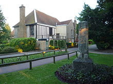
Staines-upon-Thames is a market town in northwest Surrey, England, around 17 miles west of central London. It is in the Borough of Spelthorne, at the confluence of the River Thames and Colne. Historically part of Middlesex, the town was transferred to Surrey in 1965. Staines is close to Heathrow Airport and is linked to the national motorway network by the M25 and M3. The town is part of the Greater London Built-up Area.
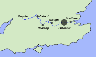
The River Thames, known alternatively in parts as the River Isis, is a river that flows through southern England including London. At 215 miles (346 km), it is the longest river entirely in England and the second-longest in the United Kingdom, after the River Severn.

Spelthorne is a local government district with borough status in Surrey, England. Its council is based in Staines-upon-Thames; other settlements in the area include Ashford, Sunbury-on-Thames, Shepperton, Stanwell and Laleham. It is named after the medieval Spelthorne Hundred which had covered the area.

Ashford is a town in Spelthorne, in Surrey, England, 14 mi (23 km) west of central London. Its name derives from a crossing point of the River Ash, a distributary of the River Colne. Historically part of Middlesex, the town has been part of Surrey since 1965. Ashford consists of relatively low density low- and medium-rise buildings, none of them being high rise. If excluding apartments most houses are semi-detached. In 2011 it had a population of 27,382.

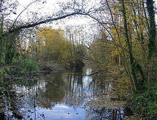
The Colne is a river and a tributary of the River Thames in England. Just over half its course is in south Hertfordshire. Downstream, it forms the boundary between Buckinghamshire and the London Borough of Hillingdon. The confluence with the River Thames is on the Staines reach at Staines-upon-Thames.

Teddington Lock is a complex of three locks and a weir on the River Thames between Ham and Teddington in the London Borough of Richmond upon Thames, England. Historically in Middlesex, it was first built in 1810.
Lower Upnor and Upper Upnor are two small villages in Medway, Kent, England. They are in the parish of Frindsbury Extra on the western bank of the River Medway. Today the two villages are mainly residential and a centre for small craft moored on the river, but Upnor Castle is a preserved monument, part of the river defences from the sixteenth century.

The Thames Estuary is where the River Thames meets the waters of the North Sea, in the south-east of Great Britain.
The River Ash is a small, shallow river in Surrey, England. Its course of 10 kilometres (6.2 mi) is just outside Greater London. Work has been carried out to re-align, clear and build up a small, Littleton head of water and create two backwaters. One backwater dates to the medieval period; the other to the 1990s. It flows as one of the six distributaries of the River Colne from the south of Staines Moor immediately south of the Staines Bypass eastwards through the rest of the borough of Spelthorne before meeting the River Thames.
Hampton Court Bridge is a Grade II listed bridge that crosses the River Thames in England approximately north–south between Hampton, London and East Molesey, Surrey, carrying the A309. It is the upper of two road bridges on the reach above Teddington Lock and downstream of Molesey Lock.

Chertsey Bridge is a road bridge across the River Thames in England, connecting Chertsey in Surrey to low-lying riverside meadows in Laleham, Surrey which is in the district of that county that was historically in Middlesex. It is 550 yards (500 m) downstream from the M3 motorway bridge over the Thames and is close to Chertsey Lock on the reach above Shepperton Lock. The bridge is a seven-arch tied arch white stone bridge built 1783–85 and is a Grade II* listed building. It has a weight restriction of 18 tonnes for LGVs.

Wheatley's Ait or Wheatley Eyot is an ait (island) in the River Thames of approximately 8 hectares on the reach above Sunbury Lock, close to the northern side and in the post town Sunbury-on-Thames however in the Borough of Elmbridge in Surrey, England.
The Thames Conservancy was a body responsible for the management of that river in England. It was founded in 1857 to replace the jurisdiction of the City of London up to Staines. Nine years later it took on the whole river from Cricklade in Wiltshire to the sea at Yantlet Creek on the Isle of Grain. Its territory was reduced when the Tideway was transferred to the Port of London Authority in 1909.

History of Staines-upon-Thames in Surrey, England, and historically in the county of Middlesex.

Chalkwell is a suburb of the city of Southend-on-Sea, in the ceremonial county of Essex, England. It is situated on the north bank of the Thames Estuary and is in traditional terms still part of Westcliff-on-Sea. The ward of Chalkwell is bordered by Woodfield Road, Leigh-on-Sea to the west, London Road to the North and Valkyrie Road, Westcliff-on-Sea to the east.
Stanwell Moor is a village and moor in the Borough of Spelthorne, approximately 17 miles (27 km) west of central London. Historically part of the county of Middlesex, it was transferred to Surrey in 1965. West of its generally narrow moor is the M25 London Orbital Motorway and the village is 1 mile (1.6 km) southwest of Heathrow Airport Terminal 5.
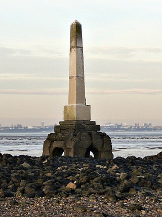
Yantlet Creek is the creek draining into the River Thames that separated the Isle of Grain from the Hoo peninsula. It once connected the River Medway with the River Thames and made the Isle of Grain a true island. The creek silted up and now drains the area of The Isle of Grain and Allhallows Marshes. A monument known as the London Stone is located at its mouth and marks the limit of the City of London's ownership of the Thames.

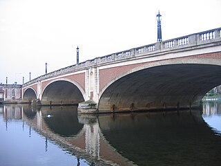
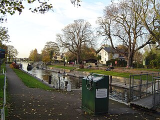
Staines Bridge is a road bridge running in a south-west to north-east direction across the River Thames in Surrey. It is on the modern A308 road and links the boroughs of Spelthorne and Runnymede at Staines-upon-Thames and Egham Hythe. The bridge is Grade II listed.

Coal-tax posts are boundary marker posts found in southern England. They were erected in the 1860s and form an irregular loop between 12 and 18 miles from London to mark the points where taxes on coal were due to the Corporation of London. There were originally around 280 posts of which around 210 remain.
Penton Hook Lock is the sixth lowest lock of forty four on the non-tidal reaches of the River Thames in England. It faces an island which was until its construction a pronounced meander and is on the site of its seasonal cutoff. It is against the left bank marking the church parish medieval border of Laleham and Staines upon Thames in Surrey for many centuries. Until 1965 their county was Middlesex. At 266 ft (81 m) it is the third longest lock on the river.