Longview Heights, Washington

Last updated

Longview Heights, Washington
CDP
Cowlitz County Washington Incorporated and Unincorporated areas Longview Heights Highlighted.svg
Location of Longview Heights, Washington
Coordinates: 46°10′56″N122°57′14″W / 46.18222°N 122.95389°W / 46.18222; -122.95389
CountryUnited States
State Washington
County Cowlitz
Area
  Total4.3 sq mi (11.1 km2)
  Land4.2 sq mi (11.0 km2)
  Water0.0 sq mi (0.1 km2)
Elevation
886 ft (270 m)
Population
 (2020)
  Total4,033
  Density940/sq mi (360/km2)
Time zone UTC-8 (Pacific (PST))
  Summer (DST) UTC-7 (PDT)
FIPS code 53-40270 [1]
GNIS feature ID1867619 [2]

Longview Heights is a census-designated place (CDP) in Cowlitz County, Washington, United States. The population was 4,033 at the 2020 Census. [3] The CDP is known locally as Columbia Heights.

Contents

Geography

Longview Heights is located at 46°10′56″N122°57′14″W / 46.18222°N 122.95389°W / 46.18222; -122.95389 (46.182099, -122.954006). [4]

According to the United States Census Bureau, the CDP has a total area of 4.3 square miles (11.1 km2), of which, 4.2 square miles (11.0 km2) of it is land and 0.04 square miles (0.1 km2) of it (0.93%) is water.

Demographics

As of the census [1] of 2000, there were 3,513 people, 1,320 households, and 1,028 families residing in the CDP. The population density was 827.5 people per square mile (319.1/km2). There were 1,401 housing units at an average density of 330.0/sq mi (127.3/km2). The racial makeup of the CDP was 95.16% White, 0.40% African American, 0.94% Native American, 1.42% Asian, 0.09% Pacific Islander, 0.43% from other races, and 1.57% from two or more races. Hispanic or Latino of any race were 1.79% of the population.

There were 1,320 households, out of which 34.4% had children under the age of 18 living with them, 66.4% were married couples living together, 7.4% had a female householder with no husband present, and 22.1% were non-families. 16.7% of all households were made up of individuals, and 4.8% had someone living alone who was 65 years of age or older. The average household size was 2.66 and the average family size was 2.98.

In the CDP, the age distribution of the population shows 26.1% under the age of 18, 8.2% from 18 to 24, 26.2% from 25 to 44, 28.7% from 45 to 64, and 10.9% who were 65 years of age or older. The median age was 39 years. For every 100 females, there were 101.4 males. For every 100 females age 18 and over, there were 99.2 males.

The median income for a household in the CDP was $48,802, and the median income for a family was $52,794. Males had a median income of $42,139 versus $24,857 for females. The per capita income for the CDP was $21,262. About 2.6% of families and 3.4% of the population were below the poverty line, including 6.1% of those under age 18 and none of those age 65 or over.

Related Research Articles

<span class="mw-page-title-main">Kongiganak, Alaska</span> CDP in Alaska, United States

Kongiganak is a census-designated place (CDP) in Bethel Census Area, Alaska, United States, and primarily sits on the eastern shore of the Kongiganak River. As of the 2010 census, the population was 439, up from 359 in 2000.

<span class="mw-page-title-main">Fox, Alaska</span> Census-designated place in Alaska, United States

Fox is a census-designated place (CDP) in Fairbanks North Star Borough, Alaska, United States. It is part of the Fairbanks, Alaska Metropolitan Statistical Area. At the 2010 census the population was 417, up from 300 in 2000.

<span class="mw-page-title-main">Parker Strip, Arizona</span> CDP in La Paz County, Arizona

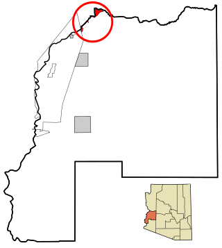
Parker Strip is a census-designated place (CDP) in La Paz County, Arizona, United States. The population was 662 at the 2010 census.

<span class="mw-page-title-main">Benton Heights, Michigan</span> Census-designated place & unincorporated community in Michigan, United States

Benton Heights is an unincorporated community in Berrien County in the U.S. state of Michigan. It is also a census-designated place (CDP) for statistical purposes without any legal status as an incorporated municipality. Per the 2020 Census, the population was 3,652. The community is a part of Benton Charter Township and is adjacent to the city of Benton Harbor.

<span class="mw-page-title-main">North Woodbridge, California</span> Former census-designated place in California, United States

North Woodbridge was a former census-designated place (CDP) in San Joaquin County, California, United States. The population was 1,320 at the 2000 census. For the 2010 census, the CDP's of South Woodbridge and North Woodbridge were merged into Woodbridge.

<span class="mw-page-title-main">Pemberton Heights, New Jersey</span> Populated place in Burlington County, New Jersey, US

Pemberton Heights is an unincorporated community and census-designated place (CDP) located within Pemberton Township, in Burlington County, in the U.S. state of New Jersey. As of the 2010 United States Census, the CDP's population was 2,423.

<span class="mw-page-title-main">Mount Healthy Heights, Ohio</span> Census-designated place in Ohio, United States

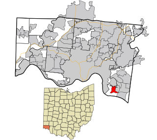
Mount Healthy Heights is a census-designated place (CDP) in Hamilton County, Ohio, United States. The population was 2,918 at the 2020 census.

<span class="mw-page-title-main">Lenape Heights, Pennsylvania</span> Census-designated place in Pennsylvania, United States

Lenape Heights is a census-designated place (CDP) in Armstrong County, Pennsylvania, United States. The population was 1,144 at the 2020 census.

Mount Gretna Heights is an unincorporated community and census-designated place (CDP) in Lebanon County, Pennsylvania, United States, adjacent to the borough of Mount Gretna. The population was 323 at the 2010 census.

<span class="mw-page-title-main">Ashland Heights, South Dakota</span> CDP in South Dakota, United States

Ashland Heights is a census-designated place (CDP) and unincorporated community in Pennington County, South Dakota, United States. The population was 678 at the 2020 census.

<span class="mw-page-title-main">Del Mar Heights, Texas</span> Census-designated place in Texas, United States

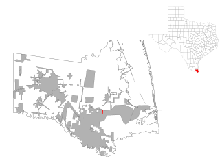
Del Mar Heights is a census-designated place (CDP) in Cameron County, Texas, United States. The population was 113 at the 2010 census. It is part of the Brownsville–Harlingen Metropolitan Statistical Area.

<span class="mw-page-title-main">Clarkston Heights-Vineland, Washington</span> CDP in Washington, United States

Clarkston Heights-Vineland is a census-designated place (CDP) in Asotin County, Washington, United States. It is part of the Lewiston, ID–WA Metropolitan Statistical Area. The population was 7,275 at the 2020 census.

<span class="mw-page-title-main">West Longview, Washington</span> Unincorporated community in Washington, United States

West Longview is an unincorporated community, which was formerly categorized as a census-designated place (CDP), in Cowlitz County, Washington. West Longview is located on western border of the city of Longview, Washington. When it was a categorized as a CDP, the population was 2,882 according to the 2000 United States Census.

<span class="mw-page-title-main">West Side Highway, Washington</span> Former CDP in Washington, United States

West Side Highway was a census-designated place (CDP) in Cowlitz County, Washington, named after a state highway running north–south between Longview and Castle Rock. As of the 2010 census, the CDP population was 5,517. Prior to the 2020 census, the CDP was split into two new CDPs, Beacon Hill and Lexington.

<span class="mw-page-title-main">East Renton Highlands, Washington</span> Census-designated place in Washington, United States

East Renton Highlands is a census-designated place (CDP) in King County, Washington, United States, located between Issaquah and Renton. The population was 11,937 at the 2020 census.

<span class="mw-page-title-main">Maple Heights-Lake Desire, Washington</span> Census-designated place in Washington, United States

Maple Heights-Lake Desire is a census-designated place (CDP) in King County, Washington, United States. At the 2020 census, the population was 3,873.

<span class="mw-page-title-main">Arlington Heights, Washington</span> CDP in Washington, United States

Arlington Heights is a census-designated place (CDP) in Snohomish County, Washington, United States. As of the 2020 census, the population was 2,477, up from 2,284 at the 2010 census.

<span class="mw-page-title-main">Terrace Heights, Washington</span> CDP in Washington, United States

Terrace Heights is a census-designated place (CDP) in Yakima County, Washington, United States. The population was 9,244 at the 2020 census. It is essentially a suburb of the city of Yakima.

<span class="mw-page-title-main">Hickam Housing, Hawaii</span> Census-designated place in Hawaii, United States

Hickam Housing is a census-designated place comprising part of Joint Base Pearl Harbor–Hickam in the City & County of Honolulu, Hawaii, United States. The population was 7,581 at the 2020 census. The CDP occupies the area is also referred to as Hickam Air Force Base.

<span class="mw-page-title-main">Salem Heights, Hamilton County, Ohio</span> Census-designated place in Ohio, United States

Salem Heights is a census-designated place (CDP) in Anderson Township, Hamilton County, Ohio, United States, adjacent to the city of Cincinnati. The population of Salem Heights was 3,862 at the 2020 census.

References

  1. 1 2 "U.S. Census website". United States Census Bureau . Retrieved January 31, 2008.
  2. "US Board on Geographic Names". United States Geological Survey. October 25, 2007. Retrieved January 31, 2008.
  3. "Census Bureau profile: Longview Heights, Washington". United States Census Bureau. May 2023. Retrieved May 9, 2024.
  4. "US Gazetteer files: 2010, 2000, and 1990". United States Census Bureau. February 12, 2011. Retrieved April 23, 2011.