
Mammoth Cave National Park is a national park in south-central Kentucky, encompassing portions of Mammoth Cave, the longest cave system known in the world. The park's 52,830 acres (21,380 ha) are located primarily in Edmonson County, with small areas extending eastward into Hart and Barren counties. The Green River runs through the park, with a tributary called the Nolin River feeding into the Green just inside the park.

Kartchner Caverns State Park is a state park of Arizona, United States, featuring a show cave with 2.4 miles (3.9 km) of passages. The park is located 9 miles (14 km) south of the town of Benson and west of the north-flowing San Pedro River. Long hidden from view, the caverns were discovered in 1974 by local cavers, assisted by state biologist Erick Campbell who helped in its preservation.

Kents Cavern is a cave system in Torquay, Devon, England. It is notable both for its archaeological and geological features. The cave system is open to the public and has been a geological Site of Special Scientific Interest since 1952 and a Scheduled Ancient Monument since 1957.

Meramec Caverns is the collective name for a 4.6-mile (7.4 km) cavern system in the Ozarks, near Stanton, Missouri. The caverns were formed from the erosion of large limestone deposits over millions of years. Pre-Columbian Native American artifacts have been found in the caverns. Currently the cavern system is a tourist attraction, with more than fifty billboards along Interstate 44 and is considered one of the primary attractions along former U.S. Highway 66. Meramec Caverns is the most-visited cave in Missouri with some 150,000 visitors annually.

Treak Cliff Cavern is a show cave near Castleton in Derbyshire, England. It is part of the Castleton Site of Special Scientific Interest and one of only two sites where the ornamental mineral Blue John is still excavated. As part of an agreement with English Nature, the Blue John that can be seen in the show cave is not mined but it is extracted in small quantities from other areas of the cave and made into saleable items like bowls, jewellery, and ornaments.

Bluespring Caverns is a cave system located in Lawrence County, Indiana, approximately 80 miles (128 km) south of Indianapolis. The cave system is a karst and river type cave formation and drains a 15 miles² (38.8 km²) sinkhole plain. The cave contains 21 miles (34 km) of surveyed passages and is most notable for having the longest known subterranean river in the United States with approximately 3 miles (4.8 km) of navigable river.

Thor's Cave is a natural cavern located at SK09865496 in the Manifold Valley of the White Peak in Staffordshire, England. It is classified as a karst cave. Located in a steep limestone crag, the cave entrance, a symmetrical arch 7.5 metres wide and 10 metres high, is prominently visible from the valley bottom, around 80 metres (260 feet) below. Reached by an easy stepped path from the Manifold Way, the cave is a popular tourist spot, with views over the Manifold Valley. The second entrance is known as the "West Window", below which is a second cave, Thor's Fissure Cavern.
Mount Benarat is a mountain located in Gunung Mulu National Park in Sarawak, Malaysia. Consisting of limestone on the western side which is overlain by gritstone on the eastern side. It contains many caves which have been discovered and explored by British and American cavers. The Benarat 2005 Caving Expedition discovered Moon Cave after climbing 60 m up the cliffs on the southern end of the mountain. On the eastern side, the Headhunter's Trail leads from the Melinau River to the mouth of the Terikan River at the Medalam River. Neighbouring Mount Buda and Mount Api are part of the same formation, separated from Mount Benarat by the Medalam and Melinau Rivers, respectively. It is also home to Benarat Cavern.

Lewis and Clark Caverns State Park is a 3,000-acre (1,200 ha) public recreation and nature preservation area located twelve miles (19 km) east of Whitehall in Jefferson County, Montana. The state park includes two visitor centers, ten miles of hiking trails, a campground, and its namesake limestone caverns. The Lewis and Clark Caverns Historic District was placed on the National Register of Historic Places in 2018.
The Mogotes de Jumagua are a set of eight elevated limestone features in the Villa Clara Province of Cuba. They are located within the orographic group Heights of the Northwest in the center-north of the island of Cuba, two kilometers south-west from the city of Sagua la Grande.
Carlsbad Caverns National Park is an American national park in the Guadalupe Mountains of southeastern New Mexico. The primary attraction of the park is the show cave Carlsbad Cavern. Visitors to the cave can hike in on their own via the natural entrance or take an elevator from the visitor center.

Lost River Cave is a seven-mile cave system located in Bowling Green, Kentucky. The Lost River originates outside of the cave and flows into it. The cave contains one of the largest natural entrances in the Eastern U.S. Boat tours are available year-round, but closed for Thanksgiving Day, Christmas Eve, Christmas Day, and New Year's Day. The river was once listed by Ripley's Believe it or Not as the "Shortest, deepest river in the world" because the blue hole is over 437 feet deep, while the river itself is only 400 feet long. In fact, the blue hole is only 16 feet deep, but is linked to a further underground river. The 72-acre cave property is jointly owned by Western Kentucky University and the non-profit Friends of Lost River Cave.
The Grutas de Cacahuamilpa National Park in Guerrero, Mexico, is best known for the Grutas de Cacahuamilpa Caverns. It is also home to the Grutas of Carlos Pacheco, a smaller system, as well as two subterranean rivers which have carved out tunnels in the rock. The park has outdoor pursuit attractions such as rappelling, and rock climbing in Limontitla Canyon. as well as the two underground rivers to explore. It also has a small botanical garden, a pool and places to camp.

Read's Cavern is a cave at Burrington Combe, Somerset, England, in which traces of Iron Age occupation have been found. It lies under Dolbury Hill. Its large main chamber has a boulder ruckle floor and is parallel to a cliff face. The cave was excavated by the University of Bristol Spelæological Society (UBSS) in the 1920s, when relics of Iron Age occupation were found.

Indiana Caverns is part of the Binkley Cave system near Corydon, Indiana.

Ruakuri Cave is one of the longer caves in the Waitomo area of New Zealand. It was first discovered by local Māori between 400 and 500 years ago. The name Te Ruakuri, or "The Den of Dogs" was given to the surrounding area when wild dogs were discovered living in the entrance of the cave.
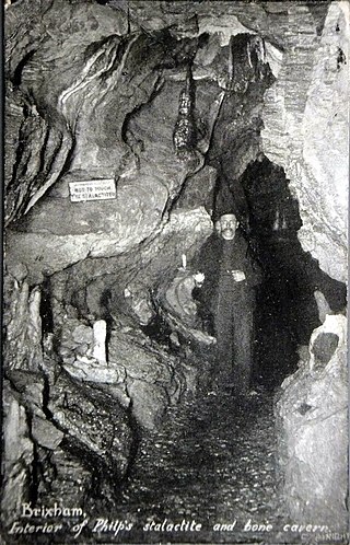
Windmill Hill Cavern is a limestone cave system in the town of Brixham, Devon. It was discovered in 1858 and later excavated by a team led by the geologist William Pengelly, who found proof that humans co-existed with extinct British fauna.

The Fenian Track is a historic walking track in Kahurangi National Park, in the West Coast Region of New Zealand. The track was originally constructed as a bridle track, to provide improved access to a gold mining site in Fenian Creek. Gold was discovered in the creek in the 1860s, but the bulk of the West Coast gold rush was happening at more accessible claims further south, so it took nearly twenty years for mining to begin. Construction of the path began at Market Cross, Karamea, in 1876, but it was not completed all the way to Fenian Creek until 1904. Returns from gold mining here were poor; although mining revived in the 1930s during the Great Depression, even with government assistance it was not a profitable claim.

Cave diving is underwater diving in water-filled caves. The equipment used varies depending on the circumstances, and ranges from breath hold to surface supplied, but almost all cave diving is done using scuba equipment, often in specialised configurations with redundancies such as sidemount or backmounted twinset. Recreational cave diving is generally considered to be a type of technical diving due to the lack of a free surface during large parts of the dive, and often involves planned decompression stops. A distinction is made by recreational diver training agencies between cave diving and cavern diving, where cavern diving is deemed to be diving in those parts of a cave where the exit to open water can be seen by natural light. An arbitrary distance limit to the open water surface may also be specified. Despite the risks, water-filled caves attract scuba divers, cavers, and speleologists due to their often unexplored nature, and present divers with a technical diving challenge.
