Louisiana Highway 35 | ||||
---|---|---|---|---|
Route information | ||||
Maintained by Louisiana DOTD | ||||
Length | 52.152 mi [1] (83.931 km) | |||
Existed | 1955 renumbering – present | |||
Major junctions | ||||
South end | ||||
North end | ||||
Location | ||||
Parishes | Vermilion, Lafayette, Acadia, St. Landry | |||
Highway system | ||||
|
Louisiana Highway 35 (LA 35) is a 52.3 miles (84.2 km)-long north-south state highway in Louisiana that serves Vermilion, Lafayette, Acadia, and Saint Landry parishes, extending from Louisiana Highway 82, intersecting with exit 87 of Interstate 10, ending at US Route 190. [2]
Lafayette Parish is a parish located in the U.S. state of Louisiana. As of the 2010 census, the population was 221,578. The parish seat is Lafayette. The parish was founded in 1823. It was named in honor of the Marquis de Lafayette, the French general who took part in the Continental Army in the American Revolutionary War and financially aided it.
Acadia Parish is a parish located in the U.S. state of Louisiana. As of the 2010 census, the population was 61,773. The parish seat is Crowley. The parish was founded from parts of St. Landry Parish in 1886, and later an election was held to determine the parish seat, ending when Crowley beat Rayne and Prairie Hayes.
St. Landry Parish is a parish located in the U.S. state of Louisiana. As of the 2010 census, the population was 83,384. The parish seat is Opelousas. The parish was created in 1807.
From the south, LA 35 begins at a junction with LA 82 located just north of the Gulf Intracoastal Waterway and an area known as Forked Island. The route heads northward and crosses LA 14 in the city of Kaplan. North of Kaplan, LA 35 briefly overlaps LA 92 to the west of Indian Bayou. About 7 miles (11 km) later, LA 35 passes through the city of Rayne, where it runs concurrent with US 90 through the center of town. After US 90 departs to the east, LA 35 passes through a diamond interchange with I-10 (exit 87) at the north end of town. This interchange is followed immediately by a junction with LA 98. Continuing northward, LA 35 passes through the rural community of Branch en route to the town of Church Point. The route zigzags through the center of town, overlapping the route of LA 95. North of Church Point, LA 35 meanders into St. Landry Parish and reaches its northern terminus at US 190 in Lawtell. [2]
Louisiana Highway 82 (LA 82) is a state highway located in southern Louisiana. It runs 142.87 miles (229.93 km) in a general east–west direction from the Texas state line east of Port Arthur to the Vermilion–Lafayette parish line southwest of Youngsville.
The Gulf Intracoastal Waterway is the portion of the Intracoastal Waterway located along the Gulf Coast of the United States. It is a navigable inland waterway running approximately 1,050 mi (1,690 km) from Carrabelle, Florida, to Brownsville, Texas.
Forked Island is an unincorporated community in Vermilion Parish, Louisiana, United States.
Prior to the 1955 Louisiana Highway renumbering, LA 35 was a road from Amite to Bogalusa via Franklinton. In 1955 the Amite-to-Franklinton segment became part of LA 16, and the Franklinton-to-Bogalusa segment became part of LA 10.
In 1955, Louisiana passed a law that undertook a comprehensive revision to the state highway classification and numbering system. The new system designated roads by importance to travel patterns and rectified the previous numbering system under new unified designations.
Amite City is a town in Tangipahoa Parish, of which it is the parish seat, in southeastern Louisiana, United States. The population was 4,110 at the 2000 census. It is part of the Hammond Micropolitan Statistical Area.
Bogalusa is a city in Washington Parish, Louisiana, United States. The population was 12,232 at the 2010 census. It is the principal city of the Bogalusa Micropolitan Statistical Area, which includes all of Washington Parish and is also part of the larger New Orleans–Metairie–Bogalusa Combined Statistical Area.
Parish | Location | mi [1] | km | Destinations | Notes | |||
---|---|---|---|---|---|---|---|---|
Vermilion | | 0.000 | 0.000 | Southern terminus; 1.0 mile (1.6 km) north of Forked Island | ||||
| 8.215 | 13.221 | ||||||
| 11.433 | 18.400 | Eastern terminus of LA 708 | |||||
Kaplan | 11.862 | 19.090 | ||||||
13.848 | 22.286 | Western terminus of LA 696 | ||||||
| 14.832 | 23.870 | Southern terminus of LA 700 | |||||
| 17.878 | 28.772 | ||||||
| 19.904 | 32.032 | South end of LA 92 concurrency | |||||
| 20.924 | 33.674 | Eastern terminus of LA 705 | |||||
| 21.434 | 34.495 | North end of LA 92 concurrency | |||||
Lafayette | No major junctions | |||||||
Acadia | | 24.614 | 39.612 | Western terminus of LA 342 | ||||
Rayne | 28.549 | 45.945 | South end of US 90 concurrency | |||||
29.129 | 46.879 | North end of US 90 concurrency; eastern terminus of LA 3076 | ||||||
29.620 | 47.669 | South end of LA 98 concurrency | ||||||
30.265– 30.403 | 48.707– 48.929 | Exit 87 on I-10 | ||||||
30.429 | 48.971 | North end of LA 98 concurrency | ||||||
| 36.326 | 58.461 | Western terminus of LA 1102 | |||||
Branch | 37.249 | 59.946 | ||||||
| 40.764 | 65.603 | Eastern terminus of LA 370 | |||||
Church Point | 42.239 | 67.977 | South end of LA 95 concurrency | |||||
42.561 | 68.495 | North end of LA 95 concurrency | ||||||
Acadia–St. Landry parish line | | 45.083 | 72.554 | Southern terminus of LA 751 | ||||
St. Landry | | 47.528 | 76.489 | |||||
| 51.336 | 82.617 | Eastern terminus of LA 752 | |||||
Lawtell | 52.087– 52.152 | 83.826– 83.931 | Northern terminus; one-way pair | |||||
1.000 mi = 1.609 km; 1.000 km = 0.621 mi
|
Interstate 12 (I-12) is an Interstate Highway located entirely within the U.S. state of Louisiana. It spans a total of 86.65 miles (139.45 km) in an east–west direction from I-10 in Baton Rouge to an interchange with both I-10 and I-59 in Slidell. Along the way, it passes through the city of Hammond, where it intersects I-55 and US 51. It also serves the smaller cities of Denham Springs and Ponchatoula, as well as the St. Tammany Parish cities of Covington and Mandeville. Skirting the northern shore of Lake Pontchartrain, I-12 serves as a northern bypass of the New Orleans metropolitan area and as an alternate route for I-10, which serves the city of New Orleans itself.
U.S. Route 167 runs for 500 miles (800 km) from Ash Flat, Arkansas at U.S. Route 62/US Route 412 to Abbeville, Louisiana at Louisiana Highway 14. It goes through the cities of Little Rock, Arkansas, Alexandria, Louisiana, and Lafayette, Louisiana.
Louisiana Highway 10 (LA 10) is a state highway located in southern Louisiana. It runs 255.51 miles (411.20 km) in an east–west direction from U.S. Highway 171 (US 171) south of Leesville to the Mississippi state line east of Bogalusa.
Louisiana Highway 27 (LA 27) is a state highway located in southwestern Louisiana. It runs 132.42 miles (213.11 km) in a general north–south direction from LA 14 in Holmwood to the junction of U.S. Highways 171 and 190 in DeRidder.
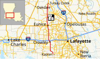
Louisiana Highway 13 (LA 13) is a state highway located in southern Louisiana. It runs 64.02 miles (103.03 km) in a north–south direction from LA 14 west of Kaplan to US 167 in Turkey Creek.
Louisiana Highway 16 (LA 16) is a state highway located in southeastern Louisiana. It runs 110.27 miles (177.46 km) in a general east–west direction from LA 22 south of French Settlement to LA 21 in Sun.
Louisiana Highway 25 (LA 25) is a state highway located in southeastern Louisiana. It runs 38.72 miles (62.31 km) in a north–south direction from U.S. Highway 190 (US 190) in Covington to the Mississippi state line north of Warnerton.
Louisiana Highway 29 (LA 29) is a state highway located in southern Louisiana. It runs 54.09 miles (87.05 km) in a north–south direction from LA 13 north of Eunice to LA 114 west of Moreauville.
Louisiana Highway 62 (LA 62) is a state highway located in Washington Parish, Louisiana. It runs 11.88 miles (19.12 km) in a north–south direction from LA 10 in Sheridan to the Mississippi state line north of State Line.
Louisiana Highway 445 is a state highway in Louisiana that serves Tangipahoa Parish. It spans 24.6 miles (39.6 km) in a south to north direction. Near its north end, it is known as Husser Road.
U.S. Highway 51 (US 51) is a part of the United States Numbered Highway System that spans 1,277 miles (2,055 km) from LaPlace, Louisiana to a point north of Hurley, Wisconsin. Within the state of Louisiana, the highway travels 69.12 miles (111.24 km) from the national southern terminus at US 61 in LaPlace to the Mississippi state line north of Kentwood.
Louisiana Highway 42 is a state highway in Louisiana that serves East Baton Rouge, Ascension, Livingston, and Tangipahoa parishes. It spans 47.8 miles (76.9 km) in a general east–west direction.
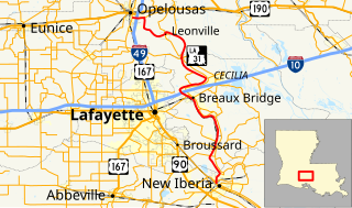
Louisiana Highway 31 is a 54.6-mile-long (87.9 km) north–south state highway in Louisiana that serves Iberia, St. Martin, and St. Landry parishes, extending from LA 182 in New Iberia, and ending at the same highway in Opelousas.
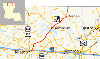
Louisiana Highway 33 (LA 33) is a state highway located in northern Louisiana. It runs 44.03 miles (70.86 km) in a southwest to northeast direction from U.S. Highway 80 (US 80) in Ruston to the Arkansas state line north of Marion.
Louisiana Highway 37 is a 42.7-mile-long (68.7 km) north-south state highway in Louisiana, United States, extending from Wooddale Boulevard in Baton Rouge to Louisiana Highway 10 in Greensburg. In East Baton Rouge Parish, the highway is named Greenwell Springs Road.
Louisiana Highway 38 (LA 38) is a state highway located in southeastern Louisiana. It runs 48.57 miles (78.17 km) in an east–west direction from LA 10 in Coleman Town to LA 430 south of Hackley.
Louisiana Highway 43 (LA 43) is a state highway located in southeastern Louisiana. It runs 44.38 miles (71.42 km) in a north–south direction from LA 42 west of Springfield to the Mississippi state line north of Easleyville, where it continues as Mississippi Highway 568 (MS 568).
Louisiana Highway 103 is a state highway located in St. Landry Parish that spans 39.5 miles (63.6 km) in a wide semi-circle around the north side of Opelousas. The route is not bannered but runs in an overall west–east direction from U.S. Highway 190 near Lawtell to LA 31 in Leonville. Along the way, it passes through the towns of Washington and Port Barre.
KML file (edit • help) |