Lumbutts

Last updated

Lumbutts
Village
Lumbutts - geograph.org.uk - 4959698.jpg
The water tower can be seen beyond the Methodist church
West Yorkshire UK location map.svg
Red pog.svg
Lumbutts
Location within West Yorkshire
OS grid reference SD952233
Civil parish
Metropolitan borough
Metropolitan county
Region
Country England
Sovereign state United Kingdom
Post town TODMORDEN
Postcode district OL14
Police West Yorkshire
Fire West Yorkshire
Ambulance Yorkshire
List of places
UK
England
Yorkshire
53°42′22″N2°04′19″W / 53.706°N 2.072°W / 53.706; -2.072

Lumbutts is a former mill village just to the south of Todmorden, in West Yorkshire, England. Lumbutts and the adjacent village of Mankinholes, were traditionally hand-loom weaving villages located on an old packhorse route that traversed the southern side of the Calder Valley. The village is east of Rochdale and west of Halifax.

Contents

History

The first documented history of the name of the village dates back to 1538. It is recorded as being from the Old Norse of Lumm and Butte, meaning a pool by an abutment of land. The second part may also come to mean a log, or stump. [1] [2] The village was traditionally associated with hand-weaving on looms, and was located on a packhorse route connecting Cheshire with Halifax and Calderdale. [3] The village is 2 miles (3.2 km) south of Todmorden, 9 miles (14 km) north-east of Rochdale, and 12 miles (19 km) west of Halifax. [4]

A corn mill was recorded at the village in 1557, but it converted to processing cotton in the 1780s. [5] During the 1830s, the village flourished as a mill village with water providing the power for the mills. This involved building several dams (Mill Dam, Lees Dam, Jumb Mill Dam, Causeway Dam, Fieldens Dam and Heeley Dam) in the village, and another on the moor to the south known as (the westerly) Gaddings Dam. [6] [7] Water through the village entered via Black Clough, and left northwards (downhill) via Lumbutts Clough. [8] [9] [10] Water from Lumbutts Clough was used to supplement the water needs in the Rochdale Canal on the valley floor, for which another dam (the easterly Gaddings Dam) was built. [11] [12] Lumbutts Old Mill closed in 1926, and was later used as a government storage location during the Second World War. After the war, the main mill building was demolished. [13] [14]

Lumbutts Old Mill had and adjacent water tower which still stands and reaches a height of 98 feet (30 m). It was built in three stages, with each stage having a vertical water wheel that was 30 feet (9.1 m) in diameter and 6 feet (1.8 m) wide. [15] Water was fed not only to each wheel individually, but also fell from the top down to the middle, and then onto bottom wheel generating around 54 horsepower. [16] [17] It is not known how the water was taken up to the uppermost stage, but it is believed a system of pumps and syphons were used. [18] The tower is now a grade II listed monument, and it was restored in 2017 with money raised through crowdfunding. [19] [20] There are several other listed buildings within the village including the Methodist church, which was established in 1837 after a schism with the Methodists in Makinholes, and a milestone. [21] [22] [23]

The old packhorse route through the village had been in existence for at least 500 years by the time of the 21st century. These routes were the only roads in the area as the valley bottom was afforested until the arrival of turnpike roads in the 1700s. [24] The road up into Lumbutts was improved in the 1820s due to the increase in finished mill products from the village. [25] Lumbutts has a two-hourly bus service into Todmorden. [26] The long-distance footpaths, the Calderdale Way and The Pennine Bridleway, both pass through the village. [27] Both Lumbutts and Makinholes were designated a conservation area in 1980. [28] There is one pub in the village, the Top Brink Inn, which used to be known as the Dog and Partridge until 1970. [29] [30] [31] [32]

Governance

Lumbutts lies within the civil parish of Todmorden, part of the metropolitan are of Calderdale in West Yorkshire. The area is represented at Westminster as part of the Calder Valley Constituency. [33]

Notable people

Related Research Articles

<span class="mw-page-title-main">Hebden Bridge</span> Town in West Yorkshire, England

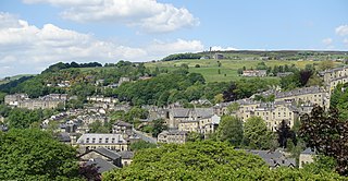
Hebden Bridge is a market town in the Calderdale district of West Yorkshire, England. It is in the Upper Calder Valley, 8 miles (13 km) west of Halifax and 14 miles (21 km) north-east of Rochdale, at the confluence of the River Calder and the Hebden Water. The town is the largest settlement in the civil parish of Hebden Royd.

<span class="mw-page-title-main">Todmorden</span> Market town and civil parish in West Yorkshire, England

Todmorden is a market town and civil parish in the Upper Calder Valley in Calderdale, West Yorkshire, England. It is 17 miles north-east of Manchester, 8 miles (13 km) south-east of Burnley and 9 miles (14 km) west of Halifax. In 2011, it had a population of 15,481.

<span class="mw-page-title-main">Calderdale</span> Metropolitan borough in West Yorkshire, England

Calderdale is a metropolitan borough of West Yorkshire, England, which had a population of 211,439. It takes its name from the River Calder, and dale, a word for valley. The name Calderdale usually refers to the borough through which the upper river flows, while the actual landform is known as the Calder Valley. Several small valleys contain tributaries of the River Calder. The main towns of the borough are Brighouse, Elland, Halifax, Hebden Bridge, Sowerby Bridge and Todmorden.

<span class="mw-page-title-main">Littleborough, Greater Manchester</span> Town in Rochdale, England

Littleborough is a town in the Metropolitan Borough of Rochdale, Greater Manchester, England, in the upper Roch Valley by the foothills of the South Pennines, 3 miles (4.8 km) northeast of Rochdale and 13 miles (20.9 km) northeast of Manchester; Milnrow and the M62 motorway are to the south, and the rural uplands of Blackstone Edge to the east. According to the 2001 census, Littleborough, and its suburbs of Calderbrook, Shore and Smithy Bridge, had a population of 13,807.

<span class="mw-page-title-main">Calder Valley line</span> Railway line in England

The Calder Valley line is a railway route in Northern England between the cities of Leeds and Manchester as well as the seaside resort of Blackpool. It is the slower of the two main rail routes between Leeds and Manchester, and the northernmost of the three main trans-Pennine routes.

<span class="mw-page-title-main">Rochdale Canal</span> Trans-Pennine navigable channel in northern England

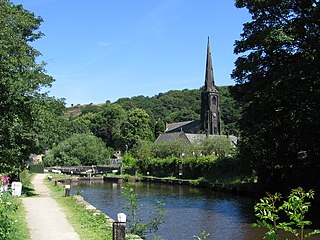
The Rochdale Canal is in Northern England, between Manchester and Sowerby Bridge, part of the connected system of the canals of Great Britain. Its name refers to the town of Rochdale through which it passes.

<span class="mw-page-title-main">Luddenden</span> District of Calderdale, West Yorkshire, England

Luddenden is a district of Calderdale 3.1 miles (5 km) west of Halifax on the Luddenden Brook in the county of West Yorkshire, England.

<span class="mw-page-title-main">Blackstone Edge</span> Gritstone escarpment in the Pennine Hills, England

Blackstone Edge is a gritstone escarpment at 472 metres (1,549 ft) above sea level in the Pennine hills surrounded by moorland on the boundary between Greater Manchester and West Yorkshire in England.

<span class="mw-page-title-main">Stoodley Pike</span> Stone monument in West Yorkshire, England

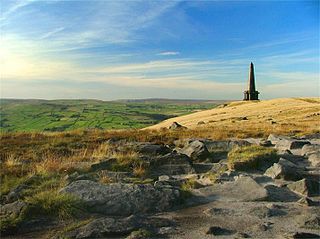
Stoodley Pike is a 1,300-foot (400 m) hill in the south Pennines in West Yorkshire in northern England. It is noted for the 121-foot (37 m) Stoodley Pike Monument at its summit, which dominates the moors of the upper Calder Valley and the market town of Todmorden. The monument is near the villages of Mankinholes and Lumbutts, West Yorkshire, and was designed in 1854 by local architect John Green, and completed in 1856 at the end of the Crimean War.

<span class="mw-page-title-main">Walsden</span> Village and civil parish in West Yorkshire, England

Walsden is a large village in the civil parish of Todmorden in the Metropolitan Borough of Calderdale, West Yorkshire, England.

<span class="mw-page-title-main">South Pennines</span> Region of moorland and hills in northern England

The South Pennines is a region of moorland and hill country in northern England lying towards the southern end of the Pennines. In the west it includes the Rossendale Valley and the West Pennine Moors. It is bounded by the Greater Manchester conurbation in the west and the Bowland Fells and Yorkshire Dales to the north. To the east it is fringed by the towns of West Yorkshire whilst to the south it is bounded by the Peak District. The rural South Pennine Moors constitutes both a Site of Special Scientific Interest and Special Area of Conservation.

<span class="mw-page-title-main">Eastwood, West Yorkshire</span> Human settlement in England

Eastwood is a place within the civil parish of Todmorden and Metropolitan Borough of Calderdale, in West Yorkshire, England. It lies 8 miles (12.9 km) west from Halifax, roughly equidistant from Todmorden's town centre, which is 2 miles (3.2 km) to the southwest, and Hebden Bridge, which is 2 miles to the northeast, along the course of the River Calder. Eastwood falls within the Calder ward of Calderdale council.

<span class="mw-page-title-main">Butterworth Hall Brook</span> Stream in Greater Manchester, England

Butterworth Hall Brook is a water course in Greater Manchester, North-West England, which flows through the village of Milnrow and is a tributary of the River Beal.

<span class="mw-page-title-main">Piethorne Brook</span> Stream in Greater Manchester, England

Piethorne Brook is a watercourse in Greater Manchester. It is a tributary of the River Beal.

<span class="mw-page-title-main">Mankinholes</span> Hamlet in West Yorkshire, England

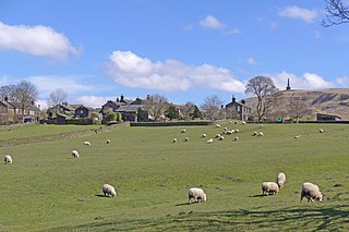
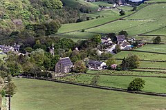
Mankinholes is a hamlet in the Metropolitan Borough of Calderdale, in West Yorkshire, England. It is situated in the Pennines and the nearest town is Todmorden. The hamlet is part of Calder Ward in Calderdale Parish Council. It has a YHA hostel, managed by the larger hostel at nearby Haworth. Mankinholes is the starting point for the popular trek up Stoodley Pike. The hill is surmounted by a 19th-century obelisk, 120 feet (37 m) high, also known as "Stoodley Pike", commemorating the end of the Crimean War.

<span class="mw-page-title-main">Mons Mill, Todmorden</span> Cotton mill in West Yorkshire, England

Mons Mill, Todmorden, is a former cotton spinning mill in Todmorden, Calderdale, West Yorkshire, England built for the Hare Spinning Company Limited. It was built in 1907, but ran into financial difficulties. It passed over to the Mons Mill (1919) Co Ltd and then was taken over by the Lancashire Cotton Corporation in 1930 and passed to Courtaulds in 1964 and production stopped in 1968. It was used into the 1990s by Ward & Goldstone Ltd. The site was cleared in 2000.

<span class="mw-page-title-main">River Calder, West Yorkshire</span> River in West Yorkshire, England

The River Calder is a river in West Yorkshire, in Northern England.

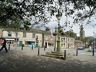
Todmorden is a market town and civil parish in the metropolitan borough of Calderdale, West Yorkshire, England. It contains over 300 listed buildings that are recorded in the National Heritage List for England. Of these, two are listed at Grade I, the highest of the three grades, eleven are at Grade II*, the middle grade, and the others are at Grade II, the lowest grade. This list contains the listed buildings in the more outlying areas of the parish, namely those along Rochdale Road to the south of its junction with Bacup Road, including the settlement of Walsden and Warland, along Bacup Road, including Clough Foot, and the surrounding outlying rural and moorland areas, including the settlements of Mankinholes and Lumbutts. The listed buildings in the inner area are in Listed buildings in Todmorden.

<span class="mw-page-title-main">Todmorden Town Hall</span> Municipal building in Todmorden, West Yorkshire, England

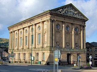
Todmorden Town Hall is a municipal building in Halifax Road, Todmorden, West Yorkshire, England. The town hall, which is the meeting place of Todmorden Town Council, is a grade I listed building.

<span class="mw-page-title-main">Gaddings Dam</span> Dam in West Yorkshire, England

Gaddings Dam is a locally owned reservoir near to Todmorden in West Yorkshire, England. The dam was built to power water mills in the Todmorden area, being superseded by steam power and left redundant. It is notable for having a sandy beach at the north-eastern side which attracts people to it during the summer months, although it is known for its all-year round wild swimming opportunities. The presence of the sandy shore means the site is often labelled as the "highest beach in Britain", though there are other inland locations with beaches at a higher altitude.

References

  1. "Lumbutts :: Survey of English Place-Names". epns.nottingham.ac.uk. Retrieved 6 April 2024.
  2. Goodall, Armitage (1914). Place-names of south-west Yorkshire, that is, of so much of the West Riding as lies south of the Aire from Keighley onwards. Cambridge: Cambridge University Press. p. 205. OCLC   5809268.
  3. "Packhorse routes to a moorland monument". The Bolton News. 29 September 2003. Retrieved 6 April 2024.
  4. LAMCA 2008, p. 11.
  5. Shaw, Megan (7 October 2023). "Life in the odd-sounding hamlet with dream postcard cornerstone". Yorkshire Live. Retrieved 6 April 2024.
  6. LAMCA 2008, p. 18.
  7. Law, Brian R. (1995). Fieldens of Todmorden : a nineteenth century business dynasty. Littleborough: Kelsall. pp. 60–61. ISBN   0946571260.
  8. "Lumbutts Clough, Calderdale - area information, map, walks and more". getoutside.ordnancesurvey.co.uk. Retrieved 6 April 2024.
  9. "River Basin Management Plan Humber River Basin District Annex D: Protected area objectives" (PDF). assets.publishing.service.gov.uk. p. 52. Retrieved 6 April 2024.
  10. Factories Inquiry Commission : Supplementary Report of the Central Board of H. Maj. Commissioners appointed to collect Information in the Manufacturing Districts, as to the Employment of Children in Factories : Ordered to be printed 25 March 1834. P. 2. London: HMSO. 1834. p. 228. OCLC   165507193.
  11. Parry 1981, p. 68.
  12. Jarratt, Jim (1988). The Fielden Trail : a ramble through Todmorden's past. Otley: Smith Settle. p. 62. ISBN   1870071158.
  13. Burton, Sally (13 May 2021). "Lovely listed property in picturesque village". The Halifax Courier. p. 33. ISSN   0961-1576.
  14. LAMCA 2008, p. 10.
  15. Jennings, Bernard, ed. (1992). Pennine Valley: a history of Upper Calderdale. Otley: Smith Settle. p. 113. ISBN   1870071948.
  16. LAMCA 2008, p. 9.
  17. Parry 1981, p. 66.
  18. Parry 1981, p. 181.
  19. Historic England. "Water tower to Lumbutts Old Mill (Grade II) (1229779)". National Heritage List for England . Retrieved 6 April 2024.
  20. Davis, Ben; Jenkinson, Pete (26 December 2023). "'A wild swimmer's paradise': the beach on top of a Yorkshire moor". The Guardian. Retrieved 7 April 2024.
  21. Historic England. "Lumbutts Methodist Church (Grade II) (1278945)". National Heritage List for England . Retrieved 6 April 2024.
  22. LAMCA 2008, p. 7.
  23. Historic England. "Milestone opposite number 21 at NGR SD956235 (Grade II) (1279309)". National Heritage List for England . Retrieved 6 April 2024.
  24. LAMCA 2008, p. 6.
  25. Law, Brian R. (1995). Fieldens of Todmorden : a nineteenth century business dynasty. Littleborough: Kelsall. p. 33. ISBN   0946571260.
  26. "T6 - Todmorden - Walsden Circular". bustimes.org. Retrieved 6 April 2024.
  27. "OL21" (Map). South Pennines. 1:25,000. Explorer. Ordnance Survey. 2015. ISBN   978-0-319-24260-5.
  28. LAMCA 2008, p. 4.
  29. Somerville, Christopher (29 December 2012). "20 glorious walks for winter". The Times. No. 70768. p. 147. ISSN   0140-0460.
  30. Holden, Joshua (1912). A short history of Todmorden; with some account of the geology and natural history of the neighbourhood. Manchester: Manchester University Press. p. 153. OCLC   1084932547.
  31. "Browse Items · Pennine Horizons Digital Archive". penninehorizons.org. Retrieved 7 April 2024.
  32. "An Assessment in Support of the Todmorden Neighbourhood Plan 2023-2032" (PDF). todmorden-tc.gov.uk. p. 308. Retrieved 7 April 2024.
  33. "Election Maps". ordnancesurvey.co.uk. Retrieved 6 April 2024. On the left of the screen is the "Boundary" tab; click this and activate either civil parishes or Westminster Constituencies (or both), however, only two functions can be active at any one time.
  34. Charlton, Peter, ed. (23 March 2011). "Jailed MP appeals for lighter sentence". The Yorkshire Post. p. 4. ISSN   0963-1496.

Sources