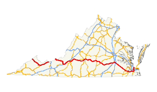
This expressway is a four-lane, divided highway with a speed limit of 55 miles per hour for its entirety (except at its northwestern terminus, where the speed limit is 45).
This article includes a list of roads, streets, highways, or other routes that are associated with the same title. If an internal link led you here, you may wish to change the link to point directly to the intended article.
Route Description
Coming into the city from the northeast, on southbound Business U.S. Route 29, the expressway crosses the James River via the Carter Glass Memorial Bridge. Almost immediately after this bridge, the expressway is overpassed by Main St. and connects to it via the Exit 1 ramps, providing full access to and from downtown and the riverfront. The road then bends southward to pass underneath Grace St., the destination of Exit 2. The exit 2 ramps heading southward form the southern end of Miller St, which continues for two blocks and then ends at Grace St. The northbound ramps connect to Robins Road, a left turn onto which is required to access Grace St.
After this, the expressway again curves to the southeast, and connects to Kemper St. (which carries U.S. Route 221, Business U.S. Route 460, and Business U.S. Route 501), with full access via Exit 3, a four-ramp partial cloverleaf/semi-folded diamond interchange. The highway then curves to the south for a rapid series of three interchanges. Exit 4 connects to Stadium Road, however, this exit only connects to the southbound route. Exit 5 connects with full access to James St. and northern Carroll Ave., both of which connect to Stadium Rd., thus providing the connections missing from Exit 4. Exit 6 has nearly no access, however, since the only ramp is from the northbound expressway to southeastern Carroll Ave.
After these tightly-knit interchanges, the expressway connects to the northwestern terminus of Odd Fellows Road with full access via a trumpet interchange.
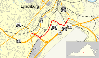
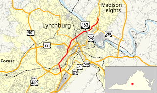
Exit 8 is a cloverleaf interchange with Candlers Mountain Road (U.S. Route 501 and Virginia State Route 128). This is where Business U.S. Route 29 (the highway carried by the expressway north of here) picks up U.S. 501 for a "wrong-way" concurrency. This interchange lacks a connection from westbound Route 128 to the southbound expressway, a connection which is made up for in Exit 9, the expressway's interchange with Wards Road. This interchange lacks access from southbound Wards Road onto northbound Business Route 29 / southbound U.S. 501 (the northbound expressway). This interchange is also where Business Route 29 leaves the expressway for Wards Road, where it eventually meets back up with mainline U.S. 29. This leaves U.S. 501 as the expressway's only designation.
After Business 29 leaves the expressway, the expressway (now Route 501) curves to the northwest, after which it has a cloverleaf interchange (Exit 10) with Timberlake Road / Fort Avenue (Business U.S. Route 460). Exit 11 soon follows, with a diamond interchange connecting the now-northbound expressway to Graves Mill Road, an important corridor connecting the City of Lynchburg with the Forest suburb. After this, the southbound expressway has a right-in/right-out intersection with Breezewood Drive, the speed limit drops to 45, and the expressway ends at an at-grade, signalized intersection with Old Forest Road and Lakeside Drive (U.S. Route 221), having made nearly a complete semicircle around the city.
Related Research Articles
Interstate 795 (I-795), also known as the Northwest Expressway, is a nine-mile freeway linking Baltimore's northwestern suburbs of Pikesville, Owings Mills and Reisterstown, Maryland to the Baltimore Beltway. The route bypasses Maryland Route 140, carrying part of MTA Maryland's Baltimore Metro SubwayLink in its median for a four-mile stretch, and provides direct access to the former Owings Mills Mall. It never connects to its parent, I-95, except via I-695.
U.S. Route 501 is a spur of U.S. Route 1. It runs 355 miles (571 km) from Buena Vista, Virginia at U.S. Route 60 to Myrtle Beach, South Carolina at U.S. Route 17 Business. It passes through the states of Virginia, North Carolina and South Carolina. From Durham to Laurinburg, a 108-mile (174 km) section of US 501 overlaps U.S. Route 15. Sections of US 15-501 also share routings with U.S. Route 1 in sections near Sanford, North Carolina and Aberdeen, North Carolina.
U.S. Route 701 is an auxiliary route of US 1 in the U.S. states of South Carolina and North Carolina. The U.S. Highway runs 171.45 miles (275.92 km) from US 17 and US 17 Alternate in Georgetown, South Carolina north to US 301, North Carolina Highway 96, and Interstate 95 (I-95) near Four Oaks, North Carolina. US 701 serves the Pee Dee region of South Carolina and the southern and central portions of Eastern North Carolina. The highway connects Georgetown and Conway in South Carolina with the North Carolina cities of Whiteville, Elizabethtown, Clinton, and a short distance north of its terminus, Smithfield. US 701 has four business routes in North Carolina, including those through Tabor City, Whiteville, Clarkton, and Clinton.
Interstate 295 (I-295) in Delaware, New Jersey, and Pennsylvania is an auxiliary Interstate Highway, designated as a bypass around Philadelphia and a partial beltway of Trenton, New Jersey. The route begins at a junction with I-95 south of Wilmington, Delaware, and runs to an interchange with I-95 in Bristol Township, Pennsylvania. The highway heads east from I-95 and crosses the Delaware River into New Jersey on the Delaware Memorial Bridge concurrent with U.S. Route 40 (US 40). Upon entering New Jersey, I-295 splits from the New Jersey Turnpike and US 40, and runs parallel to the turnpike for most of its course in the state. After a concurrency with US 130 in Gloucester County, I-295 has an interchange with I-76 and Route 42 in Camden County. The freeway continues northeast toward Trenton, where it intersects I-195 and Route 29 before bypassing the city to the east, north, and west, crossing the Delaware River on the Scudder Falls Bridge into Pennsylvania. In Pennsylvania, I-295 is signed as an east–west road and heads south to its other terminus at I-95. I-295 is one of two three-digit interstates in the United States to enter three states, with the other one being the I-275 beltway around Cincinnati which enters Ohio, Indiana, and Kentucky.
Interstate 195 (I-195) is an Interstate Highway in the U.S. state of Virginia. Known as the Beltline Expressway, the highway runs 3.50 miles (5.63 km) from Virginia State Route 195, a toll road that continues south into Downtown Richmond, north to I-64 and I-95 on the northern edge of Richmond. I-195 passes through the West End of Richmond and connects I-64 and I-95 with U.S. Route 33 and US 250, which follow Broad Street, and with SR 76, a toll road that links Richmond with the Southside of the metropolitan area.
State Route 76 is a state highway in the U.S. state of Virginia. Known as Powhite Parkway, the state highway runs 13.04 miles (20.99 km) from SR 652 near Midlothian north to Interstate 195 (I-195) in Richmond. SR 76 is a toll freeway that connects SR 288, U.S. Route 60, and SR 150 in Chesterfield County with I-195 and SR 195 west of Downtown Richmond. The highway includes a pair of mainline barrier toll plazas and ramp toll plazas at most interchanges, all of which accept E-ZPass. SR 76 is maintained by the Virginia Department of Transportation (VDOT) in Chesterfield County and the Richmond Metropolitan Authority in the city of Richmond. The Richmond section of the freeway was constructed in the early 1970s; the highway was extended to its current terminus in Chesterfield County in the late 1980s.
Interstate 395 (I-395) is an Interstate Highway in the U.S. state of Maryland. Known as Cal Ripken Way, the highway runs 1.33 miles (2.14 km) from I-95 north to Howard Street and Camden Street in Baltimore. I-395 is a spur that heads north from I-95 over the Middle Branch of the Patapsco River toward Downtown Baltimore, where it provides access to the Inner Harbor and the Baltimore Convention Center. The Interstate also serves the Camden Yards Sports Complex, which contains M&T Bank Stadium and Oriole Park at Camden Yards, homes of the Baltimore Ravens and Baltimore Orioles, respectively. I-395 also serves as the southern terminus of Martin Luther King Jr. Boulevard, an urban arterial that provides a western bypass of downtown Baltimore and connects I-95 with U.S. Route 40, US 1, and I-83. The Interstate is maintained by the Maryland Transportation Authority (MDTA) and, like all Interstates, is a part of the National Highway System.
U.S. Route 422 (US 422) is a 271-mile (436 km) long spur route of US 22 split into two segments in the U.S. states of Ohio and Pennsylvania. The western segment of US 422 begins in downtown Cleveland, Ohio and ends at Ebensburg, Pennsylvania. The eastern segment, located entirely within Pennsylvania, begins in Hershey and ends at King of Prussia, near Philadelphia. US 422 Business is the offshoot road into each of 4 towns along the way.
U.S. Route 13 is a north–south U.S. highway established in 1926 that runs for 517 miles (832 km) from Interstate 95 just north of Fayetteville, North Carolina to U.S. Route 1 in Morrisville, Pennsylvania, a northeastern suburb of Philadelphia. In the U.S. state of Virginia, US 13 runs north–south through the Hampton Roads and Eastern Shore regions of the state, using the Chesapeake Bay Bridge–Tunnel to get between the two. In the Hampton Roads area, it uses Military Highway to bypass the city centers. It is most usually a four-lane highway, sometimes up to freeway or expressway standards with controlled access.
U.S. Route 460 (US 460) in Virginia runs west-east through the southern part of the Commonwealth. The road has two separate pieces in Virginia, joined by a relatively short section in West Virginia. Most of US 460 is a four-lane divided highway and is a major artery in the southern third of the state. From Petersburg to Suffolk, US 460 is a four-lane non-divided highway. It is a popular alternative to Interstate 64 (I-64) when going from Richmond and other points in central Virginia to the Currituck Sound and Outer Banks of North Carolina, avoiding the congestion and tunnels of the more northerly I-64 corridor. The road passes through several small towns that built up at stops along the railroad line. Two of these, Windsor and Waverly, have earned reputations for being speed traps.
Pennsylvania Route 33 is a 27.7-mile-long (44.6 km) limited-access state highway in eastern Pennsylvania, United States. It runs from an interchange with Interstate 78 (I-78) just south of Easton to I-80 and PA 611 west of Stroudsburg. Until 2002, the route's southern terminus was at U.S. Route 22 (US 22), and the extension south of the US 22 interchange is known as the Gen. Anthony Clement McAuliffe 101st Airborne Memorial Highway. The route is commonly used as a hazmat bypass for the Pennsylvania Turnpike's Northeast Extension due to the restrictions in place on the Lehigh Tunnel. PA 33 provides a freeway connection between the Lehigh Valley and Pocono Mountains regions of Pennsylvania.
U.S. Route 221 (US 221) is a part of the U.S. Highway System that runs from Perry, Florida to Lynchburg, Virginia. In Virginia, the U.S. Highway runs 149.61 miles (240.77 km) from the North Carolina state line near Independence north to its northern terminus at US 29 Business, US 460 Business, and US 501 Business in Lynchburg. US 221 connects Independence, Galax, and Hillsville in Southwest Virginia while running concurrently with US 58. The U.S. Highway connects those communities with Roanoke via Floyd County, within which US 221 is the main east–west highway. The U.S. Highway also runs concurrently with US 460 from Roanoke to Bedford and parallels that U.S. Highway from Bedford to Lynchburg.
State Route 128 is a primary state highway in the U.S. state of Virginia. Known for most of its length as Mayflower Drive, the state highway runs 3.47 miles (5.58 km) from SR 163 north to U.S. Route 460 Business and US 501 Business within the independent city of Lynchburg.
State Route 163 is a primary state highway in the U.S. state of Virginia. The state highway runs 6.74 miles (10.85 km) from U.S. Route 501 and US 29 Business in Lynchburg north to US 29 Business in Madison Heights. SR 163 is the original alignment of US 29 through Lynchburg, a highway has been twice bypassed: first by the Lynchburg Expressway and later by US 29's present bypass. The state highway provides access to downtown Lynchburg and many other historic neighborhoods of the independent city.
State Route 190 is a primary state highway in the U.S. state of Virginia. The state highway runs 15.43 miles (24.83 km) from SR 166 in Chesapeake east and north to SR 225 in Virginia Beach. SR 190 is a J-shaped route that connects the central part of Chesapeake with the western part of Virginia Beach.
State Route 210 is a primary state highway in the U.S. state of Virginia. Known as Colony Road, the state highway runs 3.14 miles (5.05 km) from SR 163 in Madison Heights east to U.S. Route 29 near Madison Heights in southeastern Amherst County.
U.S. Route 40 in the U.S. state of Maryland runs from Garrett County in western Maryland to Cecil County in the state's northeastern corner. With a total length of 221 miles (356 km), it is the longest numbered highway in Maryland. Almost half of the road overlaps or parallels with Interstate 68 (I-68) or I-70, while the old alignment is generally known as US 40 Alternate, US 40 Scenic, or Maryland Route 144. West of Baltimore, in the Piedmont and Appalachian Mountains / Blue Ridge region of the Western Maryland panhandle of the small state, the portions where it does not overlap an Interstate highway are mostly two-lane roads. The portion northeast of Baltimore going toward Wilmington in northern Delaware and Philadelphia in southeastern Pennsylvania is a four-lane divided highway, known as the Pulaski Highway. This section crosses the Susquehanna River at the north end of the Chesapeake Bay on the Thomas J. Hatem Memorial Bridge.
U.S. Route 1 is a major north–south U.S. Highway, extending from the Florida Keys in the south to the Canadian border in the north. In the U.S. state of Pennsylvania, US 1 runs for 81 miles (130 km) from the Maryland state line near Nottingham to the New Jersey state line in Morrisville, through the southeastern portion of the state. The route runs southwest to northeast, and serves as a major arterial road for many of the suburbs in the Delaware Valley area. South of Philadelphia, the road mostly follows the alignment of the old Baltimore Pike. Within Philadelphia, it mostly follows Roosevelt Boulevard.
U.S. Route 202 runs through the southeastern part of the U.S. state of Pennsylvania, passing through the western and northern suburbs of Philadelphia. It follows a general southwest to the northeast direction through the state, passing through or by West Chester, King of Prussia, Bridgeport, Norristown, Montgomeryville, Doylestown, and New Hope. US 202 enters Pennsylvania from Delaware and heads north as a divided highway, where it becomes concurrent with US 322 at an intersection with US 1 in Painters Crossing. The two routes head north and become a freeway that bypasses West Chester to the east, with US 322 splitting from US 202. US 202 continues north and east along the freeway to King of Prussia, where it reverts to an at-grade divided highway following an interchange with Interstate 76 (I-76). The route becomes a one-way pair as it passes through Bridgeport and Norristown before both directions rejoin and the road continues northeast. US 202 follows an expressway-grade parkway between Montgomeryville and Doylestown before bypassing Doylestown to the south along a freeway. The route continues northeast as an at-grade road to New Hope, where it turns into a freeway again before it crosses the Delaware River on the New Hope–Lambertville Toll Bridge into New Jersey.
A total of at least sixteen special routes of U.S. Route 460 exist and at least six have been deleted.
This page is based on this Wikipedia article Text is available under the CC BY-SA 4.0 license; additional terms may apply. Images, videos and audio are available under their respective licenses.