
Saint Paul is the capital of the U.S. state of Minnesota and the county seat of Ramsey County. Situated on high bluffs overlooking a bend in the Mississippi River, Saint Paul is a regional business hub and the center of Minnesota's government. The Minnesota State Capitol and the state government offices all sit on a hill close to the city's downtown district. One of the oldest cities in Minnesota, Saint Paul has several historic neighborhoods and landmarks, such as the Summit Avenue Neighborhood, the James J. Hill House, and the Cathedral of Saint Paul. Like the adjacent city of Minneapolis, Saint Paul is known for its cold, snowy winters and humid summers.

The Metro Green Line is an 11-mile (18 km) light rail line that connects the central business districts of Minneapolis and Saint Paul in Minnesota as well as the University of Minnesota. An extension is under construction that will extend the line to the southwest connecting St. Louis Park, Hopkins, Minnetonka and Eden Prairie. The line follows the path of former Metro Transit bus route 16 along University Avenue and Washington Avenue. It is the second light-rail line in the region, after the Blue Line, which opened in 2004 and connects Minneapolis with the southern suburb of Bloomington.

Whittier is a neighborhood within the Powderhorn community in the U.S. city of Minneapolis, Minnesota, bounded by Franklin Avenue on the north, Interstate 35W on the east, Lake Street on the south, and Lyndale Avenue on the west. It is known for its many diverse restaurants, coffee shops and Asian markets, especially along Nicollet Avenue. The neighborhood is home to the Minneapolis Institute of Art, the Minneapolis College of Art and Design, and the Children's Theatre Company.

Minneapolis is officially defined by its city council as divided into 83 neighborhoods. The neighborhoods are historically grouped into 11 communities. Informally, there are city areas with colloquial labels. Residents may also group themselves by their city street suffixes: North, Northeast, South, and Southeast.
The Villager, formerly the Highland Villager, is a Saint Paul, Minnesota newspaper. It was founded by Barry Prichard and Arnold Hed in 1953 as the Highland Villager, after Saint Paul's Highland Park neighborhood, and is the oldest community newspaper in the Twin Cities. It was the first paper to be distributed in both of the Twin Cities; Minneapolis and Saint Paul. In 2007 it absorbed a sister paper, Avenues.

Minnesota State Highway 51 is a 11.274-mile-long (18.144 km) highway in Minnesota, which runs from its intersection with State Highway 5 in Saint Paul and continues north to its northern terminus at its interchange with Interstate 694 / U.S. Highway 10 in Arden Hills.

Highland Park is a neighborhood in the southwestern corner of Saint Paul, Minnesota, United States. Also known as Highland District Council, it lies along the Mississippi River just north of Fort Snelling and across the river from Minneapolis–Saint Paul International Airport. According to the 2000 census Highland Park had a population of 23,202.
Stevens Square is the southernmost neighborhood of the Central community in Minneapolis. It is bordered on Lyndale Avenue on the west, Franklin Avenue on the south, and Interstates 94 and 35W on the north and east, respectively. The portion west of Nicollet Avenue can be referred to as Loring Heights; the portion to the East as Stevens Square.

Willard-Hay is a neighborhood within the larger Near North community in the northwest side of the U.S. city of Minneapolis which is known locally as the "Northside". The neighborhood is often known as Willard-Homewood by residents; the portion south of Plymouth is Homewood. It is named after two elementary schools within its boundaries, Frances Willard and John Hay.
The Riverview Corridor is a transit corridor connecting Downtown Saint Paul and the Mall of America in Bloomington via the Minneapolis-Saint Paul International Airport. The corridor serves an area from the Saint Paul Union Depot to the Mall via a route along West 7th Street, which runs southwest from Downtown Saint Paul. The corridor creates a triangle connecting opposite ends of the Blue Line and Green Line.
Wenonah is a neighborhood on the southeast side of Minneapolis, Minnesota. Its boundaries are 54th Street to the north, 34th Avenue to the east, the Minneapolis-Saint Paul International Airport to the south, and Cedar Avenue to the west. The neighborhood contains a portion of Lake Nokomis.

Saint Paul, Minnesota, consists of 17 officially defined city districts or neighborhoods.

West Seventh is a neighborhood and city district in Saint Paul, Minnesota. It comprises three smaller neighborhoods: from west to east, the West End, Uppertown, and Irvine Park. The neighborhood lies at the base of Summit Hill and along the Mississippi River's western bluffs, spanning the entire length of West 7th Street. It is also known as Old Fort Road and the Fort Road area. The street follows a historic Native American and fur trader path along the river from downtown Saint Paul to Fort Snelling.

Summit-University is a neighborhood in Saint Paul, Minnesota, United States, that stretches roughly from University Avenue in the north, Lexington Parkway to the west, Summit Avenue to the south and to the east along John Ireland Boulevard, Kellogg Boulevard and Marion Street. Summit-University, Selby-Dale, St. Anthony Hill, Cathedral Hill, Woodland Park, Crocus Hill, Ramsey Hill, Hill District, Historic Hill District, Uni-Dale, North Quadrant, and Central Village all refer to parts of the neighborhood that is broadly known as Summit-University.

Selby Avenue is a street in Saint Paul, Minnesota, United States, that runs east–west from Summit Avenue near downtown toward the Mississippi River. The street runs through the Summit-University and Union Park neighborhoods. The street, especially between Dale Street and Snelling Avenue, has been associated with Saint Paul's black community. The far eastern end of the street has historically been more densely developed and architecturally significant.

Union Park is a neighborhood in Saint Paul in the U.S. state of Minnesota. Created as a merger of several historic neighborhoods including Merriam Park, Snelling-Hamline, Parts of Midway, Densoyer Park, and Lexington-Hamline, it is bordered by University Avenue on the north, Lexington Parkway on the east, Summit Avenue on the south, and the Mississippi National River and Recreation Area on the west. Despite the merger, many of the historic neighborhoods hold onto their original identity, especially in Lexington-Hamline and Merriam Park.

The Metro A Line is a bus rapid transit line in the Twin Cities, Minnesota operated by Metro Transit. The A Line operates primarily along the Snelling Avenue corridor and travels through the cities of Minneapolis, Saint Paul, Falcon Heights, and Roseville. From the Blue Line in Minneapolis, the line travels past Minnehaha Park, through the Highland Village commercial area, past Macalester College, and connects to the Green Line near Allianz Field. The line continues through Saint Paul, past Hamline University, before traveling through Falcon Heights and Roseville, where the line passes the Minnesota State Fairgrounds, Har Mar Mall, and terminates at Rosedale Center.

Snelling & Grand is a bus rapid transit station on the Metro A Line in Saint Paul, Minnesota.
Snelling & St. Clair is a bus rapid transit station on the Metro A Line in Saint Paul, Minnesota.
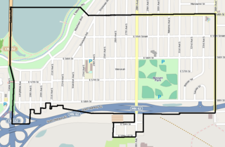
Hamline-Midway, or just Midway, is a neighborhood and city planning district in Saint Paul, Minnesota, in the United States. It is Planning District 11. The neighborhood is bounded by Transfer Road on the west, University Avenue on the south, Lexington Parkway on the east, and by the railroad tracks just north of the Pierce Butler Route, on the north. The unofficial boundaries are more loosely defined, however, and the term "Midway" is applied throughout this part of Saint Paul, often well beyond the actual location of the district. The 'Midway' name comes from being midway between downtown Minneapolis and downtown Saint Paul.
