Events in the year 1948 in India.

Junagadh is the city and headquarters of Junagadh district in the Indian state of Gujarat. Located at the foot of the Girnar hills, 355 kilometres (221 mi) southwest of Ahmedabad and Gandhinagar, it is the seventh largest city in the state.

Junagadh district is a district of the Indian state of Gujarat. Its administrative headquarters is the city of Junagadh.
Babi enters in various Indian titles. Babi or Babai is a Pashtun Tribe. Babi or Babai is son of Ghorghasht or Gharghashti. It has its origin as quoted 'Bahadur Khanji Babi, son of Usman Khan, who migrated to India and entered the Mughal service and received the hereditary title of Babi in 1554 from Emperor Humayun, for services against the Rana of Chittor'.
Events from the year 1947 in Pakistan.
Bantva, or Bantwa, is a small town in Saurashtra region of the state of Gujarat in India.
Mangrol is a town and a minor port in Junagadh district in the state of Gujarat, western India. It was formerly the seat of the princely state of Mangrol. Pin code of Mangrol is 362225.

In February 1948, the princely state of Junagadh, located in what is now the Indian state of Gujarat, was annexed to the Union of India after a dispute with the Dominion of Pakistan, regarding its accession, and a plebiscite.
Sardargardh and Bantva were princely states. Founded in 1733 by Khan Shri Sherzamankhanji Babi youngest son of Nawab Saheb Salabat Muhammadkhan Babi of Junagadh State, on the Kathiawar peninsula in Gujarat, India, they had an area of approximately 186 km2, and contained 13 primarily Muslim villages. It was a non-salute state.
Nanadiya is a small village in Gujarat, India within the Manavadar taluka of Junagadh district. It is located between Junagadh and Porbandar, around 25 km from the Arabian Sea. It has an average elevation of 24 metres (78 feet) above mean sea level.

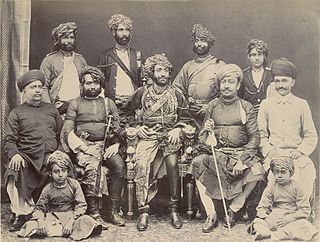
Sir Muhammad Mahabat Khanji III Rasul Khanji,, was the last ruling Nawab of Junagadh of the princely state of Junagadh in India from 1911 to 1948. He was the father of Muhammad Dilawar Khanji – former Governor of Sindh and his claimed successor. Famed for his extravagant lifestyle and his love of dogs, his decision to accede Junagadh to the Dominion of Pakistan following India's Independence led to the Indian Army taking military action. He is credited with pioneering a conservation effort in what is now the Gir National Park that saved India's last few lions from almost certain extinction.

The Babi dynasty was a Pashtun dynasty that formed the ruling royal houses of various kingdoms and later princely states. The Babai community, originally of Afghan descent, largely resides in India and some parts of Pakistan. The community traces its royal origins to the dynasty founded by Sherkhanji Babi in 1654, who was himself a ruler from the dynasty's founding until 1690. The last Nawab of the British Indian princely state of Junagadh, Sir Muhammad Khanji, signed an Instrument of Accession and acceded his princely state of Junagadh, as well as its vassal state of sardargadh, Bantva Manavadar, to the Dominion of Pakistan after the Partition of British India in 1947. However, the Dominion of India did not recognize the accession and annexed the princely state shortly afterwards.
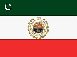
Junagarh or Junagadh was a princely state in Gujarat ruled by the Muslim Babi dynasty in India, which acceded to the Dominion of Pakistan after the Partition of British India. Subsequently, the Union of India annexed Junagadh in 1948, legitimized through a plebiscite held the same year.

Saurashtra State, formally known as United States of Kathiawar and later United States of Saurashtra, was a State of India that existed between 1948 and 1956, on Saurashtra alias Kathiawar peninsula, with Rajkot as its capital,
Nawab of Junagarh or Junagadh refers to the now defunct ex-lineage of rulers of the princely Junagarh State in British Raj, nowadays Junagadh district in the state of Gujarat in India. There are still several forts and palaces in India which were owned by princely Junagarh family but after Partition of India, this property was claimed by the Indian Government.

The princely states of Pakistan were princely states of the British Indian Empire which acceded to the new Dominion of Pakistan between 1947 and 1948, following the partition of British India and its independence.

Indra is a village in Junagdh District in the state of Gujarat, India. It is located 41 km towards west from District headquarters Junagadh.

Ghulam Moinuddin Khanji was the ruler of Manavadar State, one of the princely states associated with British India. Although Khanji chose to accede to Pakistan after the partition of India, the state was soon annexed by India and a subsequent referendum resulted in a massive Indian victory.
Pakistan's response to the revocation of the special status of Jammu and Kashmir started immediately after the revocation by India on 5 August 2019.
Youm-e-Istehsal is a day observed in Pakistan on 5 August every year as a reaction to the Revocation of the special status of Jammu and Kashmir. The Government of Pakistan subsequently designated 5 August to be observed as the Youm-e-Istehsal annually since 2020.
