Manhattan Cruise Terminal

Last updated
Manhattan Cruise Terminal
New York Cruise Terminal.svg
West-side-ship.jpg
The Costa Magica docked at Pier 92 of the terminal
General information
LocationPiers 88 and 90
711 Twelfth Avenue, (West 46th to West 54th Streets) New York, NY [1]
United States
Coordinates 40°46′05″N73°59′48″W / 40.767964°N 73.996568°W / 40.767964; -73.996568
Owned by City of New York [2]
Operated byPorts America [2] [1]
Construction
Structure typePier
ParkingYes
AccessibleYes
Other information
Website nycruise.com/manhattan-terminal
History
Opened1935
Rebuilt1974
Passengers
20161,025,534
The Normandie, renamed USS Lafayette, lies capsized in the frozen mud at Pier 88 in the winter of 1942 USS Lafayette 1942.jpg
The Normandie, renamed USS Lafayette, lies capsized in the frozen mud at Pier 88 in the winter of 1942

The Manhattan Cruise Terminal, formerly known as the New York Passenger Ship Terminal or Port Authority Passenger Ship Terminal is a ship terminal for ocean-going passenger ships in Hell's Kitchen, Manhattan, New York City. [3] It was constructed and expanded in the 1920s and 1930s as a replacement for the Chelsea Piers.

Contents

History

Construction

The New York Passenger Ship Terminal originally consisted of Piers 84, 86, 88, 90, 92 and 94, located on the Hudson River between West 44th and West 54th Street. [4] They were first designed to replace the Chelsea Piers as the city's luxury liner terminal and accommodate bigger ships that had outgrown the Chelsea Piers.

The two southernmost piers, each 1,000 feet long, were initially constructed in the 1920s to keep up with the growth in maritime traffic. [5] By the 1930s, however, even larger facilities were needed, leading to the construction between 1935 and 1937 of Piers 88–92, each 1,100 feet (340 m) long and 400 feet (120 m) apart.

The plan was to lengthen a number of existing 800-foot piers, but the US Army Corps of Engineers, who controlled the waterfront dimension, would not allow the extension of the pierhead line farther into the river, so the city was forced to extend the pier by cutting away at the land. The city had previously done this for the Chelsea Piers, however in Chelsea only landfill was removed. At the Passenger Terminal, actual Manhattan schist was taken away. [6] The results of this can also be seen in the West Side Highway's diversion eastward from West 57th to 42nd Street.

Modernization

By the 1960s, the old facilities had deteriorated and lacked the amenities of modern cruise terminals. [7] After years of planning, a new terminal was designed around Piers 88-92, to be operated by the Port Authority. Construction began in 1971 and was completed in 1974. [8]

Further renovations

In 2004, the NYPST piers began another $200 million renovation to accommodate newer and larger cruise ships. The renovation plans included the decommissioning of Pier 92 and for the remaining piers to handle three large ships at a time. [9]

Norwegian Cruise Line's ship the Norwegian Breakaway sails year-round out of the New York Passenger Ship Terminal. In 2011 the city committed $4 million to renovate and upgrade the cruise terminal to accommodate the ship. [10]

Notable incidents

During World War II, the pier was in the news when the SS Normandie caught fire and subsequently capsized at its Pier 88 berth. [11]

In response to the COVID-19 pandemic, the USNS Comfort docked at Pier 90 to assist area medical facilities by treating non-coronavirus, and later on, coronavirus-positive patients. [12] [13]

Current operation

The current ship terminal now consists only of North River piers 88 and 90.

For decades, the terminal was the only ocean-going passenger terminal in New York Harbor. Many major passenger ships have docked there, including the RMS Queen Mary 2 and Freedom of the Seas. With an upsurge in cruise ship traffic and the terminal's ability to comfortably handle only three large ships at a time, two new terminals have opened in the harbor — the Cape Liberty Cruise Port opened in 2004 in Bayonne, New Jersey (used by Royal Caribbean Cruise Line, Celebrity Cruises and Azamara Cruises), and the Brooklyn Cruise Terminal (used by the Queen Mary 2 and other ships of the Carnival Corporation cruise brands) opened in 2006 in Brooklyn.

With the opening of new piers elsewhere in the city, Piers 92 and 94 were leased to Vornado Realty Trust in 2009, for the development and operation of a mid-sized trade show and exhibition space, [14] a project that has not been realized. Piers 92 and 94 were damaged by hurricane Sandy in 2012, and in 2019 a routine city inspection found Pier 92 to be structurally unsound. [15] Vornado's current proposal is to develop a television and film studio on Pier 94. [16] Pier 86, once used by United States Lines, is now home to the USS Intrepid, which is now part of the Intrepid Sea, Air & Space Museum.

In 2003, the terminal handled 900,000 passengers, and in 2016, it handled 1.02 million.[ citation needed ]

From downstream in the river NY Passenger Ship Terminal 2007 jeh.jpg
From downstream in the river

Related Research Articles

<span class="mw-page-title-main">Staten Island Ferry</span> Passenger ferry service in New York City

The Staten Island Ferry is a fare-free passenger ferry route operated by the New York City Department of Transportation. The ferry's single route runs 5.2 miles (8.4 km) through New York Harbor between the New York City boroughs of Manhattan and Staten Island, with ferry boats making the trip in about 25 minutes. The ferry operates 24 hours a day, 7 days a week, with boats leaving every 15 to 20 minutes during peak hours and every 30 minutes at other times. Apart from NYC Ferry's St. George route, it is the only direct mass-transit connection between the two boroughs. Historically, the Staten Island Ferry has charged a relatively low fare compared to other modes of transit in the area; and since 1997, the route has been fare-free. The Staten Island Ferry is one of several ferry systems in the New York City area and is operated separately from systems like NYC Ferry and NY Waterway.

<span class="mw-page-title-main">PATH (rail system)</span> Rapid transit system in New Jersey and New York

The Port Authority Trans-Hudson (PATH) is a 13.8-mile (22.2 km) rapid transit system in the northeastern New Jersey cities of Newark, Harrison, Jersey City, and Hoboken, as well as Lower and Midtown Manhattan in New York City. It is operated as a wholly owned subsidiary of the Port Authority of New York and New Jersey. PATH trains run around the clock year-round; four routes serving 13 stations operate during the daytime on weekdays, while two routes operate during weekends, late nights, and holidays. It crosses the Hudson River through cast iron tunnels that rest on the river bottom. It operates as a deep-level subway in Manhattan and the Jersey City/Hoboken riverfront; from Grove Street in Jersey City to Newark, trains run in open cuts, at grade level, and on elevated track. In 2022, the system saw 45,501,400 rides, or about 179,900 per weekday in the second quarter of 2023.

<span class="mw-page-title-main">North River (Hudson River)</span> Section of the Hudson River between New York City and New Jersey

North River is an alternative name for the southernmost portion of the Hudson River in the vicinity of New York City and northeastern New Jersey in the United States.

<span class="mw-page-title-main">Port Authority Bus Terminal</span> Bus station in Manhattan, New York

The Port Authority Bus Terminal is a bus terminal located in Manhattan in New York City. It is the busiest bus terminal in the world by volume of traffic, serving about 8,000 buses and 225,000 people on an average weekday and more than 65 million people a year.

<span class="mw-page-title-main">NY Waterway</span> Ferry company

NY Waterway, or New York Waterway, is a private transportation company running ferry and bus service in the Port of New York and New Jersey and in the Hudson Valley. The company utilizes public-private partnership with agencies such as the Port Authority of New York and New Jersey, New Jersey Transit, New York City Department of Transportation, and Metropolitan Transportation Authority to provide service and maintain docking facilities.

<span class="mw-page-title-main">George Washington Bridge Bus Station</span> Commuter bus terminal in New York City

<span class="mw-page-title-main">Chelsea Piers</span> Entertainment complex in Manhattan, New York

Chelsea Piers is a series of piers in Chelsea, on the West Side of Manhattan in New York City. Located to the west of the West Side Highway and Hudson River Park and to the east of the Hudson River, they were originally a passenger ship terminal in the early 1900s that was used by the RMS Lusitania and was the destination of the RMS Carpathia after rescuing the survivors of the RMS Titanic. The piers replaced a variety of run-down waterfront structures with a row of grand buildings embellished with pink granite facades.

<span class="mw-page-title-main">Port of Boston</span> Seaport district in Boston, Massachusetts

The Port of Boston is a major seaport located in Boston Harbor and adjacent to the City of Boston. It is the largest port in Massachusetts and one of the principal ports on the East Coast of the United States.

<span class="mw-page-title-main">Passenger terminal (maritime)</span> Structure in a port which services passengers boarding and leaving water vessels

A passenger terminal is a structure in a port which services passengers boarding and leaving water vessels such as ferries, cruise ships and ocean liners. Depending on the types of vessels serviced by the terminal, it may be named ferry terminal, cruise terminal, marine terminal or maritime passenger terminal. As well as passengers, a passenger terminal sometimes has facilities for automobiles and other land vehicles to be picked up and dropped off by the water vessel.

<span class="mw-page-title-main">Port of San Francisco</span> Organization that oversees port facilities in San Francisco, California, United States

The Port of San Francisco is a semi-independent organization that oversees the port facilities at San Francisco, California, United States. It is run by a five-member commission, appointed by the Mayor and approved by the Board of Supervisors. The Port is responsible for managing the larger waterfront area that extends from the anchorage of the Golden Gate Bridge, along the Marina district, all the way around the north and east shores of the city of San Francisco including Fisherman's Wharf and the Embarcadero, and southward to the city line just beyond Candlestick Point. In 1968, the State of California, via the California State Lands Commission for the State-operated San Francisco Port Authority, transferred its responsibilities for the Harbor of San Francisco waterfront to the City and County of San Francisco / San Francisco Harbor Commission through the Burton Act AB2649. All eligible State port authority employees had the option to become employees of the City and County of San Francisco to maintain consistent operation of the Port of San Francisco.

<span class="mw-page-title-main">Port of New York and New Jersey</span> Port in New York and New Jersey, United States

The Port of New York and New Jersey is the port district of the New York-Newark metropolitan area, encompassing the region within approximately a 25-mile (40 km) radius of the Statue of Liberty National Monument.

<span class="mw-page-title-main">Hudson River Park</span> Public park in Manhattan, New York

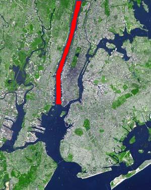
Hudson River Park is a waterfront park on the North River that extends from 59th Street south to Battery Park in the New York City borough of Manhattan. The park, a component of the Manhattan Waterfront Greenway, stretches 4.5 miles (7.2 km) and comprises 550 acres (220 ha), making it the second-largest park in Manhattan after the 843-acre (341 ha) Central Park.

<span class="mw-page-title-main">Cape Liberty Cruise Port</span> Trans-Atlantic passenger terminal in New Jersey, United States

The Cape Liberty Cruise Port is one of three trans-Atlantic passenger terminals in the Port of New York and New Jersey. It is located in Bayonne, New Jersey at the north side of the 2 mi (3.2 km) long pier of the Peninsula at Bayonne Harbor, a former military ocean terminal, and began operations in 2004.

<span class="mw-page-title-main">History of transportation in New York City</span> Aspect of history

Transportation in New York City has ranged from strong Dutch authority in the 17th century, expansionism during the industrial era in the 19th century and half of the 20th century, to cronyism during the Robert Moses era. The shape of New York City's transportation system changed as the city did, and the result is an expansive modern-day system of industrial-era infrastructure. New York City, being the most populous city in the United States, has a transportation system which includes one of the largest subway systems in the world; the world's first mechanically ventilated vehicular tunnel; and an aerial tramway.

<span class="mw-page-title-main">Industry City</span> Historic intermodal shipping, warehousing, and manufacturing complex in Brooklyn, New York

Industry City is a historic intermodal shipping, warehousing, and manufacturing complex on the Upper New York Bay waterfront in the Sunset Park neighborhood of Brooklyn, New York City. The northern portion, commonly called "Industry City" on its own, hosts commercial light manufacturing tenants across 6,000,000 square feet (560,000 m2) of space between 32nd and 41st Streets, and is operated by a private consortium. The southern portion, known as "Bush Terminal", is located between 40th and 51st Streets and is operated by the New York City Economic Development Corporation (NYCEDC) as a garment manufacturing complex.

<span class="mw-page-title-main">City Pier A</span> Pier in Manhattan, New York

Pier A, also known as City Pier A, is a pier in the Hudson River at Battery Park in Lower Manhattan, New York City. It was built from 1884 to 1886 as the headquarters of the New York City Board of Dock Commissioners and the New York City Police Department (NYPD)'s Harbor Department. Pier A, the only remaining masonry pier in New York City, contains a two- and three-story structure with a clock tower facing the Hudson River. The pier is a New York City designated landmark and is listed on the National Register of Historic Places (NRHP).

Hornblower Cruises & Events NOW City Experiences, more commonly known simply as Hornblower is a San Francisco-based charter yacht, dining cruise and ferry service company.

<span class="mw-page-title-main">111 Eighth Avenue</span> Mixed-use building in Manhattan, New York

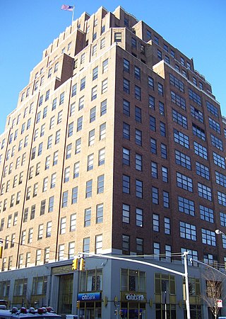
111 Eighth Avenue, also known as the Google Building and formerly known as Union Inland Terminal #1 and the Port Authority Building, is an Art Deco multi-use building in the Chelsea neighborhood of Manhattan, New York City. Fifteen stories tall and occupying an entire city block, it has 2.9 million square feet (270,000 m2) of floor space, more than the Empire State Building.

<span class="mw-page-title-main">Starrett–Lehigh Building</span> Commercial building in Manhattan, New York

The Starrett–Lehigh Building is a 19-story building at 601 West 26th Street, occupying the full block between Eleventh Avenue, 26th Street, Twelfth Avenue, and 27th Street, in the Chelsea neighborhood of Manhattan in New York City. It was built between 1930 and 1931 by the Starrett Corporation and the Lehigh Valley Railroad (LV), who formed a joint venture to develop a freight terminal and warehouse to replace the railroad's previous freight terminal. The structure was designed by the firm of Cory & Cory, with Yasuo Matsui as the associate architect and the firm of Purdy & Henderson as the consulting structural engineers. The Starrett–Lehigh Building has largely been used as an office building since the late 1990s.

<span class="mw-page-title-main">St. John's Terminal</span> Building in Manhattan, New York

St. John's Terminal, also known as 550 Washington Street, is a building on Washington Street in the Hudson Square neighborhood of Manhattan in New York City. Designed by Edward A. Doughtery, it was built in 1934 by the New York Central Railroad as a terminus of the High Line, an elevated freight line along Manhattan's West Side used for transporting manufacturing-related goods. The terminal could accommodate 227 train cars. The three floors, measuring 205,000 square feet (19,000 m2) each, were the largest in New York City at the time of their construction.

References

  1. 1 2 "Operations". NYCruise. 2015. Retrieved December 13, 2015.
  2. 1 2 "Passenger Cruise Ships". Port Authority of New York and New Jersey. 2015. Retrieved December 13, 2015.
  3. Allee King Rosen and Fleming, Inc. (May 1994). Route 9A Reconstruction Project: Final Environmental Impact Statement; Appendix B: Land Use and Socioeconomic Conditions. New York State Department of Transportation, Federal Highway Administration, United States Department of Transportation. pp. B–51. Retrieved 25 May 2016.
  4. "History & Facts". New York Cruise Terminal. Archived from the original on 2011-11-07. Retrieved 2011-11-19.
  5. Bernstein, Victor H. (1937-05-09). "IMPROVING NEW YORK'S HARBOR; With New Piers Built and Quarantine Wait Obviated, the Port Is to Aid Shipping Further by Deepening Channel". The New York Times. ISSN   0362-4331 . Retrieved 2023-05-07.
  6. Maxtone-Graham, John (2006-03-12). "Sailing Away". The New York Times. ISSN   0362-4331 . Retrieved 2017-09-19.
  7. Burks, Edward C. (1974-02-13). "Glassed‐In Terminals Rising on the Hudson". The New York Times. ISSN   0362-4331 . Retrieved 2023-05-07.
  8. Lindsey, Robert (1974-11-24). "City Opens Six‐Liner Terminal". The New York Times. ISSN   0362-4331 . Retrieved 2023-05-07.
  9. Siwolop, Sana (2005-02-16). "A Makeover for Cruise Ship Terminals". The New York Times. ISSN   0362-4331 . Retrieved 2023-05-08.
  10. "Norwegian Breakaway to Sail from New York Year-Round". Cruise Industry News. October 6, 2011. Retrieved 2011-11-19.
  11. Brouwer, Norman; La Rocco, Barbara (2004). "Epilogue". A maritime history of New York (PDF). Brooklyn, N.Y.: Going Coastal. pp. 262–295. ISBN   978-0972980319 . Retrieved 25 May 2016.
  12. Chappell, Bill (30 March 2020). "Hospital Ship USNS Comfort Arrives In New York To Ease Coronavirus Pressure". NPR.org. NPR. Retrieved 30 March 2020.
  13. USNS Comfort Transits NY Harbor and Arrives at Pier 90. YouTube . Archived from the original on 2021-12-11.
  14. Fried, Joseph P. (August 13, 2006). "The City Hopes to Double the Size of Manhattan's No. 2 Convention Center, in the West 50's". The New York Times. Retrieved April 19, 2023.
  15. Goldbaum, Christina (February 24, 2019). "Manhattan Pier Is Deemed Unsafe, Forcing Cancellation of an Art Show". The New York Times. Retrieved April 19, 2023.
  16. Beling, Sarah (2022-05-28). "Lights! Camera! Action! Pier 94 Could Make the Movies —If Developer Vornado Fulfills Promises". W42ST. Retrieved 2023-04-19.