The Cherokee are one of the indigenous peoples of the Southeastern Woodlands of the United States. Prior to the 18th century, they were concentrated in their homelands, in towns along river valleys of what is now southwestern North Carolina, southeastern Tennessee, edges of western South Carolina, northern Georgia, and northeastern Alabama.

DeKalb County is a county located in the northeastern part of the U.S. state of Alabama. As of the 2020 census, the population was 71,608. Its county seat is Fort Payne, and it is named after Major General Baron Johan DeKalb. DeKalb County is part of the Huntsville-Decatur-Albertville, AL Combined Statistical Area.

Sequoyah County is a county located in the U.S. state of Oklahoma. As of the 2020 census, the population was 39,281. The county seat is Sallisaw. Sequoyah County was created in 1907 when Oklahoma became a state. It was named after Sequoyah, who created the Cherokee syllabary and its written language.

Scouting in Alabama has a long history, from the 1910s to the present day, serving thousands of youth in programs that suit the environment in which they live.
Crossville is a town in DeKalb County, Alabama, United States. At the 2010 census the population was 1,862, up from 1,431 in 2000. Crossville is located atop Sand Mountain, a southern extension of the Cumberland Plateau.
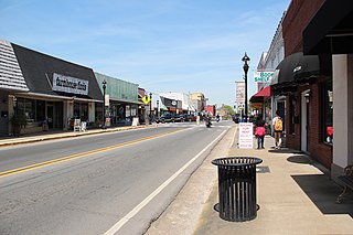
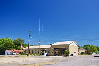
Fort Payne is a city in and county seat of DeKalb County, in northeastern Alabama, United States. At the 2020 census, the population was 14,877.
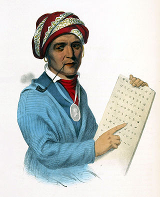
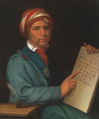
Sequoyah, also known as George Gist or George Guess, was a Native American polymath of the Cherokee Nation. In 1821, he completed his independent creation of the Cherokee syllabary, making reading and writing in Cherokee possible. His achievement was one of the few times in recorded history that an individual who was a member of a pre-literate group created an original, effective writing system. His creation of the syllabary allowed the Cherokee nation to be one of the first North American Indigenous groups to have a written language. Sequoyah was also an important representative for the Cherokee nation, by going to Washington, D.C. to sign two relocations and trading of land treaties.

The Cherokee syllabary is a syllabary invented by Sequoyah in the late 1810s and early 1820s to write the Cherokee language. His creation of the syllabary is particularly noteworthy as he was illiterate until the creation of his syllabary. He first experimented with logograms, but his system later developed into a syllabary. In his system, each symbol represents a syllable rather than a single phoneme; the 85 characters provide a suitable method for writing Cherokee. Although some symbols resemble Latin, Greek, Cyrillic, and Glagolitic letters, they are not used to represent the same sounds.

Lookout Mountain is a mountain ridge located at the northwest corner of the U.S. state of Georgia, the northeast corner of Alabama, and along the southeastern Tennessee state line in Chattanooga. Lookout Mountain was the scene of the 18th-century "Last Battle of the Cherokees" in this area during the Nickajack Expedition. On November 24, 1863, during the American Civil War, the Battle of Lookout Mountain took place here.

Tuskegee was an Overhill Cherokee town located along the lower Little Tennessee River in what is now Monroe County, Tennessee, United States. The town developed in the late 1750s alongside Fort Loudoun, and was inhabited until the late 1770s. It was forcibly evacuated and probably burned during the Cherokee–American wars.
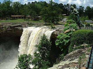
Noccalula Falls Park is a 250-acre (101-ha) public park located in Gadsden, Alabama, United States. The main feature of the park is a 90-foot (27-m) waterfall. Trails wind through Black Creek Gorge past caves, an aboriginal fort, an abandoned dam, pioneer homestead, and Civil War carvings. The park also features a petting zoo, mini-golf course, the Gilliland-Reese Covered Bridge and a replica 1863 C. P. Huntington train ride.
Willstown was an important Cherokee town of the late 18th and early 19th century, located in the southwesternmost part of the Cherokee Nation, in what is now DeKalb County, Alabama. It was near Lookout or Little Wills Creek.
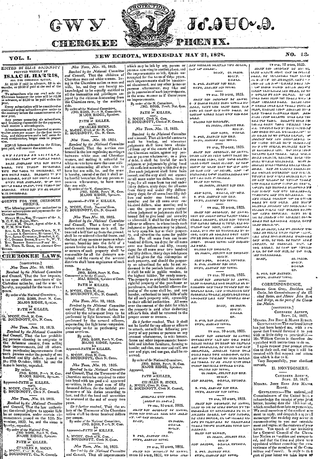
The Cherokee Phoenix is the first newspaper published by Native Americans in the United States and the first published in a Native American language. The first issue was published in English and Cherokee on February 21, 1828, in New Echota, capital of the Cherokee Nation. The paper continued until 1834. The Cherokee Phoenix was revived in the 20th century, and today it publishes both print and Internet versions.

Sand Mountain is a sandstone plateau in northeastern Alabama and northwestern Georgia and southeastern Tennessee where the plateau is known as Raccoon Mountain and Elder Mountain. It is part of the southern tip of the Appalachian mountain chain and it is the largest plateau in the chain. Geologically a continuation of Walden Ridge, Sand Mountain is part of the Cumberland Plateau, separated from the main portion of the plateau by the Tennessee River and Sequatchie Valley. The average elevation on Sand Mountain is around 1,500 feet (460 m) above sea level, compared to about 650 feet (200 m) in the surrounding area. This elevation leads to its having the coolest climate in the state of Alabama. The largest city on Sand Mountain is Albertville, in Marshall County. As of the 2010 census, the population of the city was 21,160.
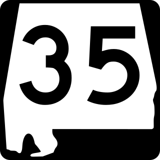
State Route 35 (SR 35) is a 68.291-mile-long (109.904 km) state highway in the northeastern part of the U.S. state of Alabama. The southern terminus of the highway is at its intersection with SR 9 in rural Cherokee County northeast of Cedar Bluff and near the Georgia state line. The northern terminus of the highway is at Woodville in Jackson County where it has a second intersection with U.S. Route 72 (US 72).

Jerry Ellis is an American author of fiction and non-fiction works best known for the book Walking the Trail written after he walked the 900 mile route of the Cherokee Trail of Tears. Ellis has been profiled and his books reviewed in several national and regional publications and on public television.

Cherokee history is the written and oral lore, traditions, and historical record maintained by the living Cherokee people and their ancestors. In the 21st century, leaders of the Cherokee people define themselves as those persons enrolled in one of the three federally recognized Cherokee tribes: The Eastern Band of Cherokee Indians, The Cherokee Nation, and The United Keetoowah Band of Cherokee Indians.

Cherokee Plantation is a historic house in Fort Payne, Alabama. The house was built in 1790 as a two-story log cabin by Andrew Ross, a judge on the Cherokee Supreme Court and brother of Principal Chief John Ross. In 1834 a second log cabin was built connected to the rear of the original cabin, and a third was built to the northeast, separated by a breezeway. Ross, being one-eighth Cherokee, was forced to leave his home in 1838 under the provisions of the Treaty of New Echota, of which Ross was a signatory; a portion of the Cherokee Trail of Tears passes in front of the house.

This article is a detailed history of the Cherokee language, the indigenous American Iroquoian language native to the Cherokee people. In 2019, the Tri-Council of Cherokee tribes declared a state of emergency for the language due to the threat of it going extinct, calling for the enhancement of revitalization programs.

Durbin Feeling was a Native American linguist who wrote the primary Cherokee–English dictionary in 1975. He is considered the greatest modern contributor to the preservation of the endangered Cherokee language.
