Manyika tribe

Last updated
Manyika
Manyika
Cluster
Ethnicity African
LocationZimbabwe, Mozambique
Parent tribeShona
Demonym
  • Wanyika
  • Manyika
  • Wasu
Branches5
Language
  • Manyika Urban Dialect
  • Manyika (Northern Manyika)
  • ChiBocha (Southern Manyika)
  • ChiJindwi
  • ChiHera
  • ChiUngwe
Religion
  • Christianity
  • African Traditional Religion (ATR)
  • Muslim
  • Non Religious

The Manyika tribe is a Shona sub-group that originated from Manyika Dynasty. Manyika people speak several dialects which include ChiManyika (Northern Manyika), ChiBocha (Southern Manyika), ChiUngwe, ChiHera, Chijindwi and the Urban dialect which is spoken in urban centers like Mutare and Rusape.

Contents

The majority of Manyika comes from the eastern region of Zimbabwe and western Mozambique. The dialect is widely spoken in Manicaland Province, upper parts of Mashonaland (Mutoko, Rushinga and Mudzi districts), Manica Province, Sofala, Tete and Zambezia. Those from Nyanga, Nyamaropa, Nyatate and surrounding regions speaks ChiManyika variant whereas those from the Buhera and Bocha areas spoke ChiHera and ChiBocha variants. There are inherent cultural norms in each of the sub-regions inhabited by the Manyika.

Language

The Manyika language is a dialect of the broader Shona language. Largely spoken by the Manyika people in the eastern parts of Zimbabwe and across the border in Mozambique. During colonization the term was taken to include all people from Manicaland an administrative province of eastern Zimbabwe. The Manyika are the people under chief Mutasa whose territory used to stretch into now Mozambique. To the south it is bordered by the Jindwi dialect also known as Chibocha. The Jindwi share borders with the Ndau in Chimanimani stretching down to Chipinge and have the Vahera to the west. The Ndau dialect is complicated on its own with people from the dry parts distinct from those from the highlands. The other cultures and dialects married into the Manyika dialect are Chiungwe which is for the people mostly under Makoni this dialect is clearly distinct form the others mentioned above. Nyanga also has a lot of other dialects that are distinct from Zezuru and the Chimanyika where they were married into. The Wanyama under chief Saunyama and the Wahwesa in Kairezi, the Tangwena in Nyamaropa and the VaBarwe are dialects that were included to make the Manyika dialect.

Variations in local vocabulary and word prefixes exist. In East Africa, manyika means "be known"; therefore, some people have Manyika as their surname. The prefix Va- (used in Shona before male names to signify seniority and respect) is Sa- in Manyika. It is also replaced by wa-; vanhu vakaenda vakawanda becomes wanhu wakaenda wakawanda. However, in some areas Zezuru and Karanga words have been completely altered when they are translated into ChiManyika; for example, the Zezuru word Nhasi (meaning "today") becomes Nyamusi in Manyika.

The identification through cultures languages and artificial boundaries worked well in separating and dividing the Zimbabweans thus making it easier for the management and control of the administrative districts. This however failed to maintain and appreciate the religious and cultural norms of these dialects. This has been adopted by the current governments though these boundaries have been shifted the identification of these dialects as representing a culture is still to be considered. This has subsequently led to the abandonment and lack of appreciation of minority cultures by so doing killing the aspect of identity and belonging.

History

In 1695 Emperor Changamire Dombo overran the rich gold-producing kingdom of Manyika, descending to the lowlands on the eastern edge of the country to destroy the Portuguese market town at Masikwesi. Dombo now controlled the whole gold-producing territory from Butwa in the southwest to Manyika in the northeast. [1]

Another use for the word Manyika was developed by the Portuguese in the late 19th century.

On a Portuguese map of 1887...its boundaries extended along the Zambezi from Shupanga to near Tete, then south-west along the Mazoe and south by the Sabi river valley to its junction with the Odzi river, then east along the Musapa and Buzi rivers to the mouth of the Pungwe. This enormous size of Manyika was evidently fixed by political and commercial considerations. The Mazoe river valley was included because of rumours of abundant alluvial gold. The Kingdom of Manyika over which the Manyika rulers...exercised authority...was a much smaller area.

H.H.H.K. Bhila, Trade and Politics in a Shona Kingdom: The Manyika and Their Portuguese and African Neighbours, 1575–1902 (London, 1982) [2]

The greatly expanded Portuguese Manyika included the territory of Maungwe; the Portuguese treated the Makoni chiefs of Maungwe as independent sovereigns and made treaties with them.

A third use of Manyika was that made by the British as a counter to claims by the Portuguese and the SaManyika people. In their attempt to gain control of "the Pungwe River route, which was the main water way to and from Beira", the British South Africa Company imposed "a treaty on Mutasa on 14 September 1890". The treaty "provided that no one could possess land in Manyika except with the consent of the BSA Company". [3] When it was signed the company invented its own "Greater Manyika", the western boundaries of which lay deep inside Portuguese territory; areas such as Mazoe and Maungwe, to which the company made different claims, were excluded. Once the company's frontiers had been fixed by means of war and arbitration, there was no longer any need to inflate the power and territory of Mutasa.

The kingdom of Manyika was divided between the two administrative districts of Umtali and Inyanga; much of its land was alienated to white farmers, and the administration was determined to advance a minimal definition of Manyikahood. "Umtassa's country and people are called Manyika", wrote Native Commissioner Umtali in January 1904. "They do not speak the same dialect as the other Mashonas". The desire to separate Mutasa from neighbouring peoples can be seen in early district reports from Umtali, in which Native Commissioner Hulley contended that the three chiefs in the district (Mutasa, Maranke and Zimunya) had distinct origins (even if there was a popular tendency to refer to his district as "Manicaland"). As far as the administrative district of Makoni was concerned, the Native Department emphasized the distinction between its people and the Manyika. In 1910 there was a boundary dispute between the Native Commissioners of Makoni and Inyanga districts. Native Commissioner Inyanga wrote Superintendent of Natives Umtali to explain why he was collecting tax from Africans on farms which lay just within the western border of Makoni district:

There are no Makoni (Shonga) natives on any of these farms. I have always acted on your suggestion—that is I have dealt with Manyikas only...[Let] the Native Commissioner Rusapi deal with Makoni natives and I with Manyika...No dispute should arise.

Inyanga, NAZ NUA 3/2/1 Native Commissioner Inyanga to Superintendent of Natives Umtali, 2 April 1910

The matter was decided; the Chief Native Commissioner determined that "the N.C., Inyanga deal with all Manyika natives and the N.C., Rusapi with all the Makoni". [4] The Native Department politically and culturally separated the Ungwe of Makoni from the Manyika. In 1915, a debate arose within the Native Department about the significance of the term mayinini in relation to Manyika marriage customs. Llewellyn Meredith (who had been Native Commissioner in both Melsetter and Makoni districts, whose inhabitants were considered Manyika) expressed his opinion about "Manica customs and language", but was scorned by the Manyika specialists. Superintendent of Natives Umtali mocked Meredith's "18 years experience of Manyika customs gathered in other districts" and invoked the authority of Archdeacon Etheridge (the leading missionary expert on Mutasa's chiefdom). "I do not of course know", wrote Etheridge, "what word may be used in Chindau, or Chirungwe, the dialects spoken in Melsetter and Rusape [Makoni] districts, but as regards Chimanyika there is no question at all". [5]

Related Research Articles

Shona is a Bantu language of the Shona people of Zimbabwe. The term is variously used to collectively describe all the Central Shonic varieties or specifically Standard Shona, a variety codified in the mid-20th century. Using the broader term, the language is spoken by over 14,000,000 people.

<span class="mw-page-title-main">Kingdom of Mutapa</span> Empire in Southern Africa from 1430 to 1760

The Kingdom of Mutapa – sometimes referred to as the Mutapa Empire, Mwenemutapa, – was an African kingdom in Zimbabwe, which expanded to what is now modern-day Mozambique.

<span class="mw-page-title-main">Manicaland Province</span> Province in Zimbabwe

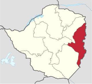
Manicaland is a province in eastern Zimbabwe. After Harare Province, it is the country's second-most populous province, with a population of 2.037 million, as of the 2022 census. After Harare and Bulawayo provinces, Manicaland is Zimbabwe's third-most densely populated province. Manicaland was one of five original provinces established in Southern Rhodesia in the early colonial period. The province endowed with country's major tourist attractions, the likes of Mutarazi Falls, Nyanga National Park and Zimbabwe's top three highest peaks. The province is divided into ten administrative subdivisions of seven rural districts and three towns/councils, including the provincial capital, Mutare. The name Manicaland is derived from one of the province's largest ethnic groups, the Manyika, who originate from the area north of the Manicaland province and as well as western Mozambique, who speak a distinct language called ChiManyika in Shona.

<span class="mw-page-title-main">Masvingo Province</span> Province in Masvingo, Zimbabwe

Masvingo, previously named Victoria, is a province in southeastern Zimbabwe. It has a population of 1.638 million as of the 2022 census, ranking fifth out of Zimbabwe's ten provinces. Established by the British South Africa Company, it was one of the five original provinces of Southern Rhodesia. In 1982, two years after Zimbabwean independence, it was renamed Masvingo Province. The province is divided into seven districts, including Masvingo District, which contains the provincial capital Masvingo City.

<span class="mw-page-title-main">Mutare</span> Largest and Admistration City of Manicaland Province, Zimbabwe

Mutare, formerly known as Umtali until 1982, is the most populous city in the province of Manicaland, and the third most populous in Zimbabwe, having surpassed Gweru in the 2012 census, with an urban population of 224,802 and approximately 260,567 in the surrounding districts, giving the wider metropolitan area a total population of over 500,000 people. Mutare is also the capital of Manicaland Province and the largest city in eastern Zimbabwe.

Manyika is a Shona language largely spoken by the Manyika tribe in the eastern part of Zimbabwe and across the border in Mozambique. It includes dialects ChiBocha, ChiUngwe, and ChiManyika, from which the broad Manyika language gets its name.

<span class="mw-page-title-main">Shona people</span> Bantu ethnic group native to Southern Africa

The Shona people are a Bantu ethnic group native to Southern Africa, primarily living in Zimbabwe where they form the majority of the population, as well as Mozambique, South Africa, and a worldwide diaspora. There are five major Shona language/dialect clusters: Manyika, Karanga, Zezuru, Korekore, and Ndau.

<span class="mw-page-title-main">Buhera District</span> District in Manicaland, Zimbabwe

Buhera District is a district in Manicaland Province, in eastern Zimbabwe.

<span class="mw-page-title-main">Cashel, Zimbabwe</span> Village in Manicaland, Zimbabwe

Cashel is a village in Chimanimani District of Manicaland Province, Zimbabwe. It is located near the Mozambique border, just north of the Chimanimani Mountains. Forestry, bananas, wheat, and various cash crops are grown in the area. It was originally called Penkridge but was changed to Cashel in 1957. It was named after Lt. Col. E. Cashel, a former member of the British South Africa Police and the Rhodesian Volunteers, who retired to this area after World War I. The Cashel valley is well known for radio and television commercials, which sought to extol the quality of its peas, beans and other agricultural products.

<span class="mw-page-title-main">Nehanda Charwe Nyakasikana</span>

Nehanda Charwe Nyakasikana also known as Mbuya Nehanda was a svikiro, or spirit medium of the Zezuru Shona people. She was a medium of Nehanda, a female Shona mhondoro. As one of the spiritual leaders of the Shona, she was one of the leaders of a revolt, the Chimurenga, against the British South Africa Company's colonisation of what is now Zimbabwe led by Cecil John Rhodes in 1889. She was a Hera of the HwataShava Mufakose Dynasty. She and her ally Sekuru Kaguvi were eventually captured and executed by the company on charges of murder. She has been commemorated by Zimbabweans by statues, songs, novels, and poems, and the names of streets and hospitals. The legacy of the medium continued to be linked to the theme of resistance, particularly the guerrilla war that began in 1972. Her name became of increasing importance to the nationalist movements in Zimbabwe.

Watsomba is a shopping centre in the province of Manicaland, Zimbabwe located 42 km north of the city of Mutare on the main Mutare-Nyanga road. It is an administrative and trading centre for Mutasa District and the Mutasa and Manyika communal lands. Around Watsomba are farms surrounding the growth point namely ruwodo farm, muringami farm, sakupwanya farm, madziwa farm, sagonda farm, Nyamutaira farm, Mutasa farm, Mandimutsira farms, Mundoma farm, Mvere Farm, Nyakurukwa Farm and Makoni Farm.

<span class="mw-page-title-main">Zimunya</span> Paramount Chiefdom in Manicaland Province, Zimbabwe

Zimunya, also referred to by the Jindwi people of Zimunya as "Jindwi", is a Paramount Chiefdom in Manicaland Province, Zimbabwe under Chief Zimunya.

<span class="mw-page-title-main">Makoni District</span> Place in Manicaland, Zimbabwe

Makoni District is a district in Manicaland Province of northeastern Zimbabwe.

<span class="mw-page-title-main">Mberengwa District</span> Administrative district in Midlands, Zimbabwe

Mberengwa, originally known as Belingwe, is a district in Midlands province in Zimbabwe. The district is now divided into sub-districts: Mberengwa North, East, West and South. It is bounded by Gwanda in Mberengwa west, and by Zvishavane in its northern zone, to the south it stretches to Neshuro, Chikombedzi and bounded by Manyuchi dam.

The pre-colonial history of Zimbabwe lasted until the British government granted colonial status to Southern Rhodesia in 1923.

Mutasa District is one of seven districts in Manicaland Province of Zimbabwe. Mutasa District is located 30 km northeast of Mutare and stretches up to the Honde Valley, which is about 100 km northeast of Mutare along a tarred road that branches off the Nyanga road.

<span class="mw-page-title-main">Languages of Zimbabwe</span> Languages of Zimbabwe

Many languages are spoken, or historically have been spoken, in Zimbabwe. Since the adoption of its 2013 Constitution, Zimbabwe has 16 official languages, namely Chewa, Chibarwe, English, Kalanga, Koisan, Nambya, Ndau, Ndebele, Shangani, Shona, sign language, Sotho, Tonga, Tswana, Venda, Xhosa. The country's main languages are Shona, spoken by only 42% of the population, and Ndebele, spoken by roughly 39%. English is the country's lingua franca, used in government and business and as the main medium of instruction in schools. English is the first language of most white Zimbabweans, and is the second language of a majority of black Zimbabweans. Historically, a minority of white Zimbabweans spoke Afrikaans, Greek, Italian, Polish, and Portuguese, among other languages, while Gujarati and Hindi could be found amongst the country's Indian population. Deaf Zimbabweans commonly use one of several varieties of Zimbabwean Sign Language, with some using American Sign Language. Zimbabwean language data is based on estimates, as Zimbabwe has never conducted a census that enumerated people by language.

<span class="mw-page-title-main">Kingdom of Zimbabwe</span> Medieval kingdom in Southern Africa (c.1220-1450)

The Kingdom of Zimbabwe was a medieval Shona kingdom located in modern-day Zimbabwe. Its capital, today's Masvingo, which is commonly called Great Zimbabwe, is the largest stone structure in precolonial Southern Africa. This kingdom came about after the collapse of the Kingdom of Mapungubwe.

<span class="mw-page-title-main">Christianity in Zimbabwe</span>

Christianity is the largest religion practiced in Zimbabwe, accounted for more than 84% of the population. The arrival of Christianity dates back to the 16th century by Portuguese missionaries such as Fr. Gonsalo Da Silveira of the Roman Catholic Church. Christianity is embraced by the majority of the population. It is estimated 85 percent of Zimbabweans claim to be Christians, with approximately 62 percent regularly attending church services. Christian faith plays a very important role in the organization of Zimbabwean society.

Joyce Simango is a Zimbabwean author. She became the first female Shona novelist when she published Zviuya Zviri Mberi, or "Good Things are Ahead", in 1974.

References

  1. Terence Ranger, "Missionaries, Migrants and the Manyika"
  2. H.H.H.K. Bhila|Trade and Politics in a Shona Kingdom: The Manyika and Their Portuguese and African Neighbours, 1575–1902 (London, 1982)
  3. Bhila, p. 237.
  4. NAZ NUA 3/2/1 Superintendent of Natives Umtali to Chief Native Commissioner, 8 April 1910; comment by Chief Native Commissioner.
  5. NAZ NUA 3/2/2 Memorandum, "Mayinini", 20 December 1915.