Mapleton, Brooklyn

Last updated

Mapleton is a neighborhood in southern Brooklyn, New York City, bounded by 16th Avenue on the west, Dahill Road on the east, 57th Street on the north, and 65th Street on the south. It borders Bensonhurst and Borough Park to the west, and Midwood to the east.

Contents

The area was originally developed in the 1910s, and was sometimes called "Mapleton Park". Today, Mapleton is an ethnically diverse, mostly residential area with low-density housing.

History

Mapleton, Brooklyn
Location in New York City

The site of Mapleton was originally part of the town of New Utrecht in the 17th and 18th centuries. The area, as did the rest of Brooklyn, became part of New York City in 1898. [1]

Mapleton was developed in the early 1910s in conjunction with the construction of the Sea Beach subway line, which replaced a former surface-level railroad. Many of the homes were built on 30-by-100-foot (9.1 by 30.5 m) plots subdivided from former farmland. [1] By 1914, there were dozens of single-family homes being constructed around the nearby subway stations. The eastern part of Mapleton was developed by the Alco Building Company, who built low-density housing in that area, and was known as Mapleton Park. [2] With the opening of the Sea Beach Line in June 1915, Mapleton gained direct subway access to Manhattan, and developers were able to sell $1 million worth of real estate. [3] By December of the same year, it was estimated that the three Sea Beach Line stations in Mapleton accommodated a combined 4,000 passengers daily. [4]

In 1927, Congregation Tiffareth Israel decided to construct a synagogue and yeshiva at 64th Street and 20th Avenue. The foundation of the synagogue and school had been completed in 1924. [5] A new building for the Mapleton branch of the Brooklyn Public Library was constructed starting in 1953, [6] and it opened in 1955. [7]

Description

According to a 2012 New York Times profile of the neighborhood, Mapleton is bounded by 16th Avenue on the west, Dahill Road on the east, 47th Street on the north, and 65th Street on the south. It is mostly residential and contains mainly single-family homes. The portion of Mapleton south of 60th Street is often combined with Bensonhurst, while the portion north of 60th Street is often considered part of Borough Park. The neighborhood is ethnically diverse and contains a large Italian, Jewish, and Asian population. [1]

Transportation

The New York City Subway has several stations in the neighborhood. The BMT Sea Beach Line ( N train) runs in a trench between 63rd and 64th Streets, on Mapleton's southwest edge, with stations at 18th Avenue, 20th Avenue, and Bay Parkway. The IND Culver Line ( F and <F> trains) runs along McDonald Avenue, near Mapleton's eastern edge, and stops at the Bay Parkway, Avenue N, and Avenue P stations. [8]

The B6 , B8 and B9 buses also stop within the neighborhood. The B6 runs along Bay Parkway and the B8 runs along 18th Avenue, while the B9 runs along 60th Street. [8]

Education

PS 48 PS48 Mapleton 18 Av 61 St jeh.jpg
PS 48

The Mapleton School (PS 48) is located at 18th Avenue and 60th Street and serves kindergarten through fifth grade. Mapleton also contains the Franklin Delano Roosevelt High School, located at 20th Avenue and 59th Street. [1]

The Brooklyn Public Library (BPL) has two branches in Mapleton. The Ryder branch is located at 5902 23rd Avenue, between 59th and 60th Streets. Opened in April 1970 and designed by Arthur Witthoefft, the Ryder branch has one of the BPL's busiest circulating collections. [9] The Mapleton branch is located at 1702 60th Street, near 17th Avenue. Founded in the 1930s, the Mapleton branch moved to its present building in 1955. [7]

Points of interest

Washington Cemetery Washington Cemetery.jpg
Washington Cemetery

Mapleton contains Washington Cemetery, the largest inhabited Jewish cemetery in New York. Many Orthodox Jews are buried there, as are many prominent people. The cemetery is located on Bay Parkway and stretches from 59th Street to East 3rd Street. [1]

Mapleton contains the 6.38-acre (2.58 ha) Gravesend Park, located on 18th Avenue between 56th and 57th Streets. The park was created in 1917 and was named after the nearby neighborhood of Gravesend. [10] It contains two baseball fields, two basketball courts, fitness equipment, four handball courts, and four playgrounds. [10] [11] Gravesend Park was renovated in 2016 for $7.25 million. [11] Properties in the neighborhood that were too small to develop, such as Dahill Triangle, have also been designated as parks.

The neighborhood also contained a park named Mapleton Park (also known as Mapleton Oval) at 62nd Street and 20th Avenue, which was completed in 1916. [12] The field lasted through at least 1920 [1] and was the home of the Mapleton Park Nine baseball team. [13] The oval may have been named after an old neighborhood name for the area. Today, the legacy of the name Mapleton Park exists in a local synagogue, the Young Israel of Mapleton Park, near 65th Street and Bay Parkway (22nd Avenue). [1]

Maple Lanes, a 48-lane bowling alley, was formerly located at 16th Avenue and 60th Street. It opened in 1960 [14] and was sold in 2012 to a developer, who planned to demolish the bowling alley to construct condominiums and a synagogue. [15] At the time of its closing, Maple Lanes was one of the few remaining bowling alleys in Brooklyn. [14]

Related Research Articles

<span class="mw-page-title-main">Coney Island</span> Neighborhood of Brooklyn in New York City

Coney Island is a peninsular neighborhood and entertainment area in the southwestern section of the New York City borough of Brooklyn. The neighborhood is bounded by Brighton Beach to its east, Lower New York Bay to the south and west, and Gravesend to the north and includes the subsection of Sea Gate on its west. More broadly, the Coney Island peninsula consists of Coney Island proper, Brighton Beach, and Manhattan Beach. This was formerly the westernmost of the Outer Barrier islands on the southern shore of Long Island, but in the early 20th century it became a peninsula, connected to the rest of Long Island by land fill.

<span class="mw-page-title-main">Borough Park, Brooklyn</span> Neighborhood of Brooklyn in New York City

Borough Park is a neighborhood in the southwestern part of the borough of Brooklyn, in New York City. The neighborhood is bordered by Bensonhurst to the south, Dyker Heights to the southwest, Sunset Park to the west, Kensington and Green-Wood Cemetery to the northeast, Flatbush to the east, and Mapleton to the southeast.

<span class="mw-page-title-main">Gravesend, Brooklyn</span> Neighborhood of Brooklyn in New York City

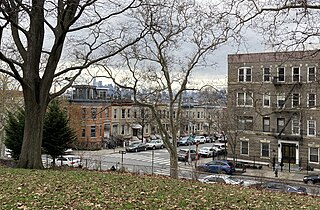
Gravesend is a neighborhood in the south-central section of the New York City borough of Brooklyn, on the southwestern edge of Long Island in the U.S. state of New York. It is bounded by the Belt Parkway to the south, Bay Parkway to the west, Avenue P to the north, and Ocean Parkway to the east.

<span class="mw-page-title-main">Bensonhurst, Brooklyn</span> Neighborhood of Brooklyn in New York City

Bensonhurst is a residential neighborhood in the southwestern section of the New York City borough of Brooklyn. The neighborhood is bordered on the northwest by 14th Avenue, on the northeast by 60th Street, on the southeast by Avenue P and 22nd Avenue and on the southwest by 86th Street. It is adjacent to the neighborhoods of Dyker Heights to the northwest, Borough Park and Mapleton to the northeast, Bath Beach to the southwest, and Gravesend to the southeast.

<span class="mw-page-title-main">Belt Parkway</span> Highway in New York

The Belt Parkway is the name given to a series of controlled-access parkways that form a belt-like circle around the New York City boroughs of Brooklyn and Queens. The Belt Parkway comprises three of the four parkways in what is known as the Belt System: the Shore Parkway, the Southern Parkway, and the Laurelton Parkway. The three parkways in the Belt Parkway are a combined 25.29 miles (40.70 km) in length. The Cross Island Parkway makes up the fourth parkway in the system, but is signed separately.

<span class="mw-page-title-main">Sunset Park, Brooklyn</span> Neighborhood in New York City

Sunset Park is a neighborhood in the western part of the New York City borough of Brooklyn, bounded by Park Slope and Green-Wood Cemetery to the north, Borough Park to the east, Bay Ridge to the south, and New York Harbor to the west. The neighborhood is named for a public park of the same name that covers 24.5 acres (9.9 ha) between Fifth and Seventh Avenues from 41st to 44th Street. The area north of 36th Street is alternatively known as Greenwood Heights, while the section north of 24th Street is also called South Slope.

<span class="mw-page-title-main">Eastern Parkway–Brooklyn Museum station</span> New York City Subway station in Brooklyn

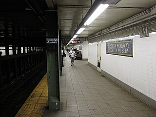
The Eastern Parkway–Brooklyn Museum station is a local station on the IRT Eastern Parkway Line of the New York City Subway. Located at the intersection of Washington Avenue and Eastern Parkway in Brooklyn adjacent to the Brooklyn Museum, it is served by the 2 train at all times, the 3 train at all times except late nights, and the 4 train during late nights.

<span class="mw-page-title-main">Canarsie, Brooklyn</span> Neighborhood in New York City

Canarsie is a mostly residential neighborhood in the southeastern portion of Brooklyn, New York City. Canarsie is bordered on the east by Fresh Creek Basin, East 108th Street, and Louisiana Avenue; on the north by Linden Boulevard; on the west by Ralph Avenue; on the southwest by Paerdegat Basin; and on the south by Jamaica Bay. It is adjacent to the neighborhoods of East Flatbush to the west, Flatlands and Bergen Beach to the southwest, Starrett City to the east, East New York to the northeast, and Brownsville to the north.

<span class="mw-page-title-main">Kensington, Brooklyn</span> Neighborhood of Brooklyn in New York City

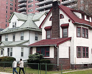
Kensington is a neighborhood in the central portion of the New York City borough of Brooklyn, located south of Prospect Park and Green-Wood Cemetery. It is bordered by Coney Island Avenue to the east; Fort Hamilton Parkway and Caton Avenue to the north; McDonald Avenue, Dahill Road or 36th Street to the west; and Ditmas Avenue or Foster Avenue to the south. Kensington and Parkville are bordered by the Prospect Park South and Ditmas Park subsections of Flatbush to the east; Windsor Terrace to the north; Borough Park to the west; and Midwood to the south.

<span class="mw-page-title-main">Bath Beach, Brooklyn</span> Neighborhood of Brooklyn in New York City

Bath Beach is a neighborhood in the New York City borough of Brooklyn, located at the southwestern edge of the borough on Gravesend Bay. The neighborhood borders Bensonhurst and New Utrecht to the northeast across 86th Street; Dyker Beach Park and Golf Course to the northwest across 14th Avenue; and Gravesend to the east across Stillwell Avenue.

<span class="mw-page-title-main">Mill Basin, Brooklyn</span> Neighborhood of Brooklyn in New York City

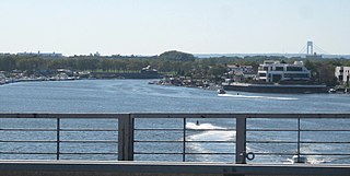
Mill Basin is a residential neighborhood in southeastern Brooklyn, New York City. It is on a peninsula abutting Jamaica Bay and is bordered by Avenue U on the northwest and the Mill Basin/Mill Island Inlet on its remaining sides. Mill Basin is adjacent to the neighborhood of Bergen Beach to the northeast, Flatlands to the northwest, Marine Park to the southwest, and Floyd Bennett Field and the former Barren Island to the southeast. Mill Basin also contains a subsection called Old Mill Basin, north of Avenue U.

<span class="mw-page-title-main">Ocean Parkway (Brooklyn)</span> Boulevard in Brooklyn, New York

Ocean Parkway is a 4.86-mile-long (7.82 km) boulevard in the west-central portion of the New York City borough of Brooklyn. It is inventoried by the New York State Department of Transportation (NYSDOT) as New York State Route 908H (NY 908H), an unsigned reference route.

<span class="mw-page-title-main">Fifth Avenue–59th Street station</span> New York City Subway station in Manhattan

The Fifth Avenue–59th Street station is a station on the BMT Broadway Line of the New York City Subway. Located under Grand Army Plaza near the intersection of 5th Avenue and 60th Street in Manhattan, it is served by the N train at all times, the W train on weekdays during the day, and the R train at all times except late nights.

<span class="mw-page-title-main">Eastern Parkway</span> Boulevard in Brooklyn, New York

Eastern Parkway is a major east–west road in the New York City borough of Brooklyn. Designed by Frederick Law Olmsted and Calvert Vaux, it was built between 1870 and 1874 and has been credited as the world's first parkway. At the time of its construction, Eastern Parkway went to the eastern edge of Brooklyn, hence its name.

<span class="mw-page-title-main">Brooklyn Manor station</span> Former LIRR station (closed 1962)

The Brooklyn Manor station was a station on the Long Island Rail Road's Rockaway Beach Branch located on the south side of Jamaica Avenue at 100th Street, straddling the border between Richmond Hill and Woodhaven in Queens, New York City. The station name referred to the nearby Brooklyn Manor section of Woodhaven, originally a 603-lot development bounded by Woodhaven Boulevard to the west, 96th/98th Streets to the east, Forest Park to the north, and Jamaica Avenue to the south. The station opened in January 1911, and was constructed as a replacement for the Brooklyn Hills station, which was located 3,000 feet (910 m) to the north. This station closed along with the rest of the Rockaway Beach Branch in 1962, and was subsequently demolished.

<span class="mw-page-title-main">Utica Avenue</span> Avenue in Brooklyn, New York

Utica Avenue is a major avenue in Brooklyn, New York City, New York, United States. It is one of several named for the city of Utica in Upstate New York. It runs north–south and occupies the position of East 50th Street in the Brooklyn street grid, with East 49th Street to its west and East 51st Street to its east for most of its path. The south end of Utica Avenue is at Flatbush Avenue; its north end is at Fulton Street, beyond which it is continued by Malcolm X Boulevard in Bedford–Stuyvesant. Malcolm X Boulevard continues to Broadway, where it terminates on Broadway between Lawton Street and Hart Street.

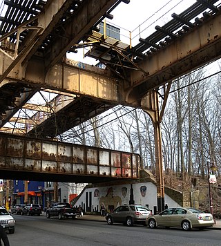
The IRT Eastern Parkway Line is one of the lines of the A Division of the New York City Subway. Built for the Interborough Rapid Transit Company (IRT), it stretches from Downtown Brooklyn south along Flatbush Avenue and east along Eastern Parkway to Crown Heights. After passing Utica Avenue, the line rises onto an elevated structure and becomes the New Lots Line to the end at New Lots Avenue in East New York, Brooklyn. The west end of the Eastern Parkway Line is at the Joralemon Street Tunnel under the East River.

References

  1. 1 2 3 4 5 6 7 Gregor, Alison (December 14, 2012). "Living In Mapleton, Brooklyn — When Is a Neighborhood a Sandwich?". The New York Times. ISSN   0362-4331 . Retrieved February 21, 2019.
  2. "BIG INCREASE IN BROOKLYN'S BUILDING OPERATIONS DUE TO PROSPECTIVE BENEFITS FROM NEW SUBWAYS; Plans Under Way for Scores of Medium-Priced Homes in Outlying Districts -- Mapleton Park Activity Along Sea Beach Line -- Eastern Parkway's Choice Residential Streets Showing Rapid Improvement -- Steady Demand for Medium-Priced Flats -- Business Expansion in Borough Hall Section". The New York Times. July 12, 1914. ISSN   0362-4331 . Retrieved February 21, 2019.
  3. "MAPLETON PARK ACTIVITY.; Realty Sales of $1,000,000 Due to New Subway Line". The New York Times. April 18, 1915. ISSN   0362-4331 . Retrieved February 21, 2019.
  4. "MORE SEA BEACH TRAFFIC.; Three Mapleton Stations Contribute 4,000 Passengers Daily". The New York Times. December 5, 1915. ISSN   0362-4331 . Retrieved February 21, 2019.
  5. "To Erect New Synagogue: Congregation Tiffareth Israel To Build In Mapleton Park". The New York Times. October 23, 1927. p. RE1. ProQuest   104079685.
  6. "LIBRARY BRANCH PLANNED; Brooklyn to Get Mapleton Unit -- Williamsburg Repairs Set". The New York Times. November 27, 1953. ISSN   0362-4331 . Retrieved February 21, 2019.
  7. 1 2 "Mapleton Library". Brooklyn Public Library. August 22, 2011. Retrieved February 21, 2019.
  8. 1 2 "Brooklyn Bus Map" (PDF). Metropolitan Transportation Authority. October 2020. Retrieved December 1, 2020.
  9. "Ryder Library". Brooklyn Public Library. August 22, 2011. Retrieved February 21, 2019.
  10. 1 2 "Gravesend Park : NYC Parks". www.nycgovparks.org. Retrieved February 21, 2019.
  11. 1 2 Katinas, Paula (August 18, 2016). "Gravesend Park reopens after $7.25 million renovation". Brooklyn Daily Eagle. Retrieved February 21, 2019.
  12. Real Estate Record and Builders' Guide. C.W. Sweet & Company. 1916.
  13. "Some Other Ballparks in Brooklyn". BrooklynBallParks.com.
  14. 1 2 Robbins, Liz (April 22, 2011). "At Maple Lanes, Bowlers Prepare for Loss". The New York Times. ISSN   0362-4331 . Retrieved February 21, 2019.
  15. "Beloved Brooklyn Bowling Alley 'Maple Lanes' Being Sold To Developer". CBS New York. September 10, 2012. Retrieved February 21, 2019.

40°37′05″N73°58′48″W / 40.618°N 73.980°W / 40.618; -73.980