MapmyIndia

Last updated

MapmyIndia
FormerlyC.E. Infosystems Pvt. Ltd. (1995–2021)
Company type Public
Industry
Founded1995;29 years ago (1995)
Founder
  • Rakesh Verma
  • Rashmi Verma
HeadquartersOkhla Phase-III, New Delhi, India [1]
Area served
Indian subcontinent
Key people
  • Rakesh Verma (CMD)
  • Rohan Verma (CEO)
  • Sapna Ahuja (COO)
  • Ankeet Bhat (CSO)
  • Anuj Jain (CFO)
ServicesIoT, Navigation, Maps, GIS Services
OwnerCE Info Systems Ltd. (Cestem)
Number of employees
1410[ citation needed ]
Website www.mapmyindia.com

MapmyIndia is an Indian technology company that builds digital map data, telematics services, location-based SaaS and GIS AI technologies. [2] [3] The company was founded in 1995 and is headquartered at New Delhi with regional offices in Mumbai and Bengaluru and smaller offices across India. It also has international offices in the San Francisco Bay Area and Tokyo. [1]

Contents

History

MapmyIndia was founded by Rakesh and Rashmi Verma in 1995. [4] The couple launched a startup called CE Info Systems in 1995 at New Delhi, India. [5] [6] The company started working upon developing a web mapping technology and provide products and services required for enhancing marketing and logistics efficiency in existing organizations in the country. [7] Soon after, the company took up an assignment to develop good quality maps with detailed topography to support the marketing and logistics operations of Coca-Cola and Cellular One. [8]

The company launched the first Indian interactive digital mapping portal "www.mapmyindia.com" in 2004. [9] This portal provided free, customized, location-based services including assigning an e-location to existing addresses to enable last mile deliveries to their exact destinations. The services were available for mobile phones with internet connectivity also. These services were also provided through the MapmyIndia portal to MagicBricks. [10]

In 2010, MapmyIndia launched a GPS navigation service called Road Pilot, preloaded with Indian cities, villages and destinations. [11] The company's online maps are integrated with ISRO Satellite Imagery for detailed satellite and hybrid. [12]

In 2014, MapmyIndia launched a voice-navigation app called NaviMaps, that supported various languages spoken in India, including Hindi, Bengali, Gujarati, Kannada, Malayalam, Marathi, Oriya, Punjabi, Tamil and Telugu. [13]

In 2020, MapmyIndia launched a COVID-19 dashboard. [14]

MapmyIndia won the Government of India's AatmaNirbhar Bharat App Innovation Challenge for its consumer app, Move. [15]

Product and services

MapmyIndia offers Navigation, Tracking, IoT, Analytics and web mapping service for desktop and mobile devices. [5] [16] The company also offers advanced GPS tracking devices, car in-dash infotainment & plug & play on-board diagnostics car tracker. [17] [18] The navigation service features street view, public transit information and turn-by-turn navigation with spoken instructions for vehicles. It later launched offline navigation app, Navimaps that uses offline vector data to offer 3D terrains and city models and 3D building for in-car infotainment systems. [19] [20] [21]

Market share

The company's navigation and location services are primarily used by vehicle manufacturers (cars, bikes, commercial vehicles, electric vehicles) and it has 95% market share on GPS navigation in India. [22] [4] It also claims to have 5,000 enterprise customers with 80% market share in the location intelligence space. [23] [24] MapmyIndia's cloud mapping services are also used by many developers and tech companies in India such as PhonePe, Paytm, Amazon, Alexa voice, Flipkart, Uber, Ola Cabs, Blinkit, etc. for planning, operations and customer experience. [25]

Funding

MapmyIndia has raised $34 million in venture capital financing in the three rounds since 2007 from the Lightbox Ventures, Nexus Venture Partners, [26] Qualcomm Ventures and Zenrin. [27] In 2015, Flipkart announced that it has acquired 34% stake of the company for Rs 1,600 crores and provided a successful exit to MapmyIndia's early investors. [28]

Related Research Articles

<span class="mw-page-title-main">Automotive navigation system</span> Part of the automobile controls

An automotive navigation system is part of the automobile controls or a third party add-on used to find direction in an automobile. It typically uses a satellite navigation device to get its position data which is then correlated to a position on a road. When directions are needed routing can be calculated. On the fly traffic information can be used to adjust the route.

<span class="mw-page-title-main">Google Maps</span> Googles web mapping service (launched 2005)

Google Maps is a web mapping platform and consumer application offered by Google. It offers satellite imagery, aerial photography, street maps, 360° interactive panoramic views of streets, real-time traffic conditions, and route planning for traveling by foot, car, bike, air and public transportation. As of 2020, Google Maps was being used by over one billion people every month around the world.

<span class="mw-page-title-main">TomTom</span> Dutch manufacturer of automotive navigation systems

TomTom N.V. is a Dutch multinational developer and creator of location technology and consumer electronics. Founded in 1991 and headquartered in Amsterdam, TomTom released its first generation of satellite navigation devices to market in 2004. As of 2019 the company has over 4,500 employees worldwide and operations in 29 countries throughout Europe, Asia-Pacific, and the Americas.

<span class="mw-page-title-main">Satellite navigation device</span> Device that can calculate its geographical position based on satellite information

A satellite navigation device, satnav device or satellite navigation receiver is a user equipment that uses one or more of several global navigation satellite systems (GNSS) to calculate the device's geographical position and provide navigational advice. Depending on the software used, the satnav device may display the position on a map, as geographic coordinates, or may offer routing directions.

<span class="mw-page-title-main">Here Technologies</span> Netherlands-based mapping data company

Here Technologies is a Dutch multinational group specialized in mapping technologies, location data and related automotive services to individuals and companies. It is majority-owned by a consortium of German automotive companies and American semiconductor company Intel whilst other companies also own minority stakes. Its roots date back to U.S.-based Navteq in 1985, which was acquired by Finland-based Nokia in 2007. Here is currently based in The Netherlands.

Google Maps Navigation is a mobile application developed by Google for the Android and iOS operating systems that later integrated into the Google Maps mobile app. The application uses an Internet connection to a GPS navigation system to provide turn-by-turn voice-guided instructions on how to arrive at a given destination. The application requires a connection to Internet data and normally uses a GPS satellite connection to determine its location. A user can enter a destination into the application, which will plot a path to it. The app displays the user's progress along the route and issues instructions for each turn.

<span class="mw-page-title-main">Kia Connect</span>

Kia Connect, formerly UVO eServices, is a paid subscription OEM infotainment and telematics service offered by Kia Motors America on select vehicles for the United States market. The system allows users to make hands-free calls on their smartphone, stream music, navigate to a POI, and perform vehicle diagnostics with the use of voice commands.

<span class="mw-page-title-main">Sygic</span> Slovak automotive navigation technology company

Sygic is a Slovak company of global automotive navigation systems for mobile phones and tablets. The company was founded in 2004 and is headquartered in Bratislava, Slovakia. It became the first company to offer navigation for iPhone and second for Android. In 2015 Sygic reached milestone of 100 million downloads of its navigation app.

Flipkart Private Limited is an Indian Multinational e-commerce company, headquartered in Bangalore, and incorporated in Singapore as a private limited company. The company initially focused on online book sales before expanding into other product categories such as consumer electronics, fashion, home essentials, groceries, and lifestyle products.

<span class="mw-page-title-main">Turn-by-turn navigation</span> Feature of GPS navigation devices

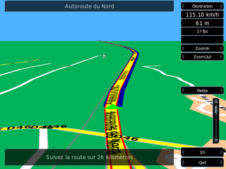
Turn-by-turn navigation is a feature of some satellite navigation devices where directions for a selected route are continually presented to the user in the form of spoken or visual instructions. The system keeps the user up-to-date about the best route to the destination, and is often updated according to changing factors such as traffic and road conditions. Turn-by-turn systems typically use an electronic voice to inform the user whether to turn left or right, the street name, and the distance to the next turn.

Telenav, Inc. is a wireless location-based services corporation that provides services including Global Positioning System (GPS) satellite navigation, local search, automotive navigation solutions, mobile advertising, enterprise mobility and workflow automation. The company’s headquarters are located in Santa Clara, California in the United States with additional offices in the U.S., Germany, Japan, Romania, China, and Brazil.

<span class="mw-page-title-main">OsmAnd</span> Offline maps & navigation Android and iOS app

OsmAnd is a map and navigation app for Android and iOS. It uses the OpenStreetMap (OSM) map database for its primary displays, but is an independent app not endorsed by the OpenStreetMap Foundation. It is available in both free and paid versions; the latter unlocks the download limit for offline maps and provides access to Wikipedia points of interest (POIs) and their descriptions from within the app. Map data can be stored on the device for offline use. Using the device's GPS capabilities, OsmAnd offers routing, with visual and voice guidance, for car, bike, and pedestrian. All of the main functionalities work both online and offline.

<span class="mw-page-title-main">Apple Maps</span> Map application operated by Apple Inc.

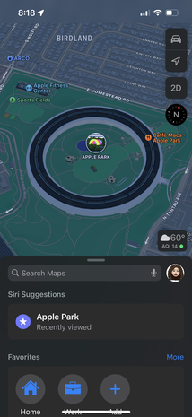
Apple Maps is a web mapping service developed by Apple Inc. The default map system of iOS, iPadOS, macOS, and watchOS, it provides directions and estimated times of arrival for driving, walking, cycling, and public transportation navigation. A "Flyover" mode shows certain densely populated urban centers and other places of interest in a 3D landscape composed of models of buildings and structures.

Mireo d.d. is a company and brand that produces global automotive navigation systems for smartphones, personal navigation devices and in-car infotainment systems. They also provide fleet management and vehicle tracking services and produce detailed maps of Croatia, Bosnia and Herzegovina. Mireo was founded in 2001 in Zagreb, Croatia and sells proprietary navigation products in over 70 countries.

This article contains a list with gratis satellite navigation software for a range of devices. Some of the free software mentioned here does not have detailed maps or the ability to follow streets or type in street names. However, in many cases, it is also that which makes the program free, avoid the need of an Internet connection, and make it very lightweight. Very basic programs like this may not be suitable for road navigation in cars, but serve their purpose for navigation while walking or trekking, and for use at sea. To determine the GPS coordinates of a destination, one can use sites such as GPScoordinates.eu and GPS visualizer.

<span class="mw-page-title-main">Android Auto</span> Mobile app providing a vehicle-optimized user interface

Android Auto is a mobile app developed by Google to mirror features of an Android device, such as a smartphone, on a car's dashboard information and entertainment head unit.

<span class="mw-page-title-main">Here WeGo</span> Web mapping and navigation service since 2012

Here WeGo is a web mapping and satellite navigation software, operated by HERE Technologies and available on the Web and mobile platforms. It is based on HERE's location data platform, providing its in-house data, which includes satellite views, traffic data, and other location services. Maps are updated every two or three months.

<span class="mw-page-title-main">Locus Map</span>

Locus Map is a multi-functional Android navigation app. Primarily it is designed and used for leisure time outdoor activities like hiking, biking, or geocaching. The app is also used by professionals e.g. by S&R teams or for collecting geospatial data.

PhonePe is an Indian Multinational digital payments and financial services company headquartered in Bengaluru, Karnataka, India. PhonePe was founded in December 2015, by Sameer Nigam, Rahul Chari and Burzin Engineer. The PhonePe app, based on the Unified Payments Interface (UPI), went live in August 2016.

References

  1. 1 2 K.S.V. Menon & Garima Malik (10 June 2016). Funding Options for Startups: A Conceptual Framework and Practical Guide. Notion Press. p. 29. ISBN   978-1-945400-80-3.
  2. Our Bureau (17 April 2017). "MapmyIndia to build 'Digital Map Twin of the Real World' | Business Line". Thehindubusinessline.com. Retrieved 21 August 2017.
  3. "MapMyIndia: This navigation system will help you reach the doorstep of your destination; here's how". The Financial Express. 10 February 2017. Retrieved 21 August 2017.
  4. 1 2 "MapmyIndia Story: The 25 Year Journey Of Maps, GPS, And More". Inc42 Media. 13 June 2017. Retrieved 29 October 2018.
  5. 1 2 Layak, Suman (25 February 2018). "As MapmyIndia enters Google territory, can it beat the Goliath of internet?". The Economic Times. Retrieved 29 October 2018.
  6. "Japanese map publisher Zenrin's Indian partner in expansion drive". The Japan Times Online. 24 April 2017. ISSN   0447-5763 . Retrieved 29 October 2018.
  7. "MapmyIndia 2.0: Battling for supremacy | Forbes India". Forbes India. Retrieved 29 October 2018.
  8. "Use Customer Cash to Finance Your Start-Up" . Retrieved 1 August 2023.
  9. "Meet MapmyIndia, the 'Desi Google Map'". www.afaqs.com. 21 March 2017. Retrieved 29 October 2018.
  10. "Locate your house with MapmyIndia V-2007" . Retrieved 1 August 2023.
  11. "MapmyIndia launches new GPS navigator". The Economic Times. 12 March 2010. Retrieved 29 October 2018.
  12. "MapMyIndia Launches Digital Twin Of Real World - NDTV CarAndBike". NDTV . Retrieved 29 October 2018.
  13. "Mapmyindia launches new app with voice navigation in regional languages - MediaNama". www.medianama.com. 30 May 2014. Retrieved 29 October 2018.
  14. "COVID-19 India Tracker - Coronavirus Cases, Testing Labs, Treatment & Isolation Centres in India". maps.mapmyindia.com. Retrieved 16 November 2020.
  15. Malhotra, Vanshika (8 August 2020). "AtmaNirbhar Bharat app innovation challenge: Here are the winners of the contest". www.indiatvnews.com. Retrieved 16 November 2020.
  16. "How MapmyIndia is planning rival to Google Maps - The Financial Express". www.financialexpress.com. 18 January 2018. Retrieved 29 October 2018.
  17. "MapmyIndia to launch vehicle-tracking device". @businessline. Retrieved 29 October 2018.
  18. "MapmyIndia to launch vehicle-tracking device". The Hindu . 3 September 2018.
  19. "MapmyIndia 'NaviMaps' Navigation App for iOS Now Available for Download". NDTV Gadgets360.com. Retrieved 29 October 2018.
  20. PTI (29 July 2014). "MapmyIndia launches 'NaviMaps', an offline navigation app for iOS". BGR India. Archived from the original on 29 October 2018. Retrieved 29 October 2018.
  21. "Android Auto App Gets Satellite View: Google Maps Finally Looks Realistic While In True In-Car Navigation Mode - MySmartPrice News". MySmartPrice. 20 July 2018. Retrieved 29 October 2018.
  22. "Car GPS devices: What is better? Smartphone or dedicated device; here is guide for you - The Financial Express". www.financialexpress.com. 13 November 2017. Retrieved 29 October 2018.
  23. "IT majors to benefit from regulatory push for telematics - Times of India". The Times of India. Retrieved 29 October 2018.
  24. "Flipkart-backed MapmyIndia acquires VIDTEQ". VCCircle. 18 April 2017. Retrieved 29 October 2018.
  25. "Can MapMyIndia beat Google to be the navigator of 'Atmanirbhar Bharat'?". Moneycontrol. 28 August 2020. Retrieved 16 November 2020.
  26. Staff, Edit (9 August 2007). "MapMyIndia Gets Over $2.5 Million In Funding From Nexus India Capital". gigaom.com. Archived from the original on 17 November 2019. Retrieved 29 October 2018.
  27. "An atlas of opportunity". Outlook. Retrieved 29 October 2018.
  28. Chanchani, Madhav; Dave, Sachin (4 December 2015). "Flipkart picking up 34% stake in digital mapping firm MapmyIndia in Rs 1,600 crore deal". The Economic Times. Retrieved 29 October 2018.