Related Research Articles

Marengo County is a county located in the west central portion of the U.S. state of Alabama. As of the 2020 census, the population was 19,323. The largest city is Demopolis, and the county seat is Linden. It is named in honor of the Battle of Marengo near Turin, Italy, where French leader Napoleon Bonaparte defeated the Austrians on June 14, 1800.
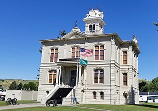
Columbia County is a county located in the U.S. state of Washington. As of the 2020 census, the population was 3,952, making it the second-least populous county in Washington. The county seat and largest city is Dayton. The county was created out of Walla Walla County on November 11, 1875, and is named after the Columbia River. Columbia County is included in the Walla Walla, WA Metropolitan Statistical Area.
Linden is a city in and the county seat of Marengo County, Alabama, United States. The population was 1,930 at the 2020 census, down from 2,123 at the 2010 census.

The Northwestern United States, also known as the American Northwest or simply the Northwest, is an informal geographic region of the United States. The region consistently includes the states of Oregon, Washington, Idaho, Montana and Wyoming. Some sources include Southeast Alaska in the Northwest. The related but distinct term "Pacific Northwest" generally excludes areas from the Rockies eastward, whereas the term "Inland Northwest" excludes areas west of the Cascades.
There are over 30 lakes named Mud Lake within the U.S. state of Washington.

Dixons Mills is an unincorporated community in Marengo County, Alabama, United States. The community was named for a group of mills operated by Joel B. Dixon in the 19th century. Dixons Mills has a post office utilizing the 36736 ZIP code.

The Lewiston–Clarkston metropolitan area—colloquially referred to as the Lewiston–Clarkston Valley or Lewis–Clark Valley, and officially known as the Lewiston, ID–WA Metropolitan Statistical Area—is a metropolitan area comprising Nez Perce County, Idaho, and Asotin County, Washington. The metro is anchored by the cities of Lewiston, Idaho, and Clarkston, Washington—named after Meriwether Lewis and William Clark, respectively. As of the 2010 census, the MSA had a population of 60,888, making it the 4th smallest metropolitan area in the United States.
Wenaha National Forest was established as the Wenaha Forest Reserve by the U.S. Forest Service in Oregon and Washington on May 12, 1905 with 731,650 acres (2,960.9 km2). It became a National Forest on March 4, 1907. On November 5, 1920 the entire forest was transferred to Umatilla National Forest and the name was discontinued.

Vineland is an unincorporated community in the southeastern corner of Marengo County, Alabama, United States. Vineland had several stores, a cotton gin, and Baptist and Methodist churches. It also had a post office from 1887 to 1916, with Julius A. Kimbrough serving as the first postmaster and Solomon S. Strickland as the last. This general area, which also included Surginer and Hampden, was originally known as Pineville Precinct. Pineville was also an early name for Putnam, in the southwestern corner of the county.
Octagon is an unincorporated community in Marengo County, Alabama, United States. Octagon had a post office at one time, but it no longer exists.
Coxheath is an unincorporated community in Marengo County, Alabama, United States. Coxheath had a post office at one time, but it no longer exists.
Camp Wooten Retreat Center is a group camp in the Washington State Park System located fifteen miles south of Pomeroy in Columbia County, Washington. It consists of a 1930s-era dining hall and many cabins and other facilities on the Tucannon River and Donnie Lake in the Blue Mountains. Available activities include indoor swimming, canoeing on the lake, hiking, archery and other athletic facilities.
Marengo Wind Farm is an electricity generating wind farm facility located near Dayton, Washington, United States. It is owned by PacifiCorp and began operations in 2007. The facility has a generating capacity of 140 megawatts.
Marengo Township is a township in Iowa County, Iowa, United States.
Marengo is a hamlet in the Town of Galen, Wayne County, New York, United States, located near the Seneca County line. It is located six miles (10 km) southwest of the Village of Clyde, at an elevation of 420 feet. The primary intersection in the hamlet is at Clyde-Marengo Road and Lyons-Marengo Road.
Covello is an unincorporated community in Columbia County, in the U.S. state of Washington.
Huntsville is an unincorporated community in Columbia County, in the U.S. state of Washington.
Jackson is an unincorporated community in Columbia County, in the U.S. state of Washington.
Turner is an unincorporated community in Columbia County, in the U.S. state of Washington.
Blackwater Township is an inactive township in Pettis County, in the U.S. state of Missouri.
References
- ↑ Meany, Edmond S. (1923). Origin of Washington geographic names. Seattle: University of Washington Press. p. 159.
Municipalities and communities of Columbia County, Washington, United States | ||
|---|---|---|
| City | 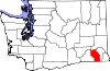 | |
| Town | ||
| Unicorporated communities | ||
| Ghost towns | ||
46°26′26″N117°44′56″W / 46.4406°N 117.7490°W
| | This Columbia County, Washington state location article is a stub. You can help Wikipedia by expanding it. |