
The National Road was the first major improved highway in the United States built by the federal government. Built between 1811 and 1837, the 620-mile (1,000 km) road connected the Potomac and Ohio Rivers and was a main transport path to the West for thousands of settlers. When improved in the 1830s, it became the second U.S. road surfaced with the macadam process pioneered by Scotsman John Loudon McAdam.

The Great River Road is a collection of state and local roads that follow the course of the Mississippi River through ten states of the United States. They are Minnesota, Wisconsin, Iowa, Illinois, Missouri, Kentucky, Tennessee, Arkansas, Mississippi and Louisiana. It formerly extended north into Canada, serving the provinces of Ontario and Manitoba. The road is designated as both a National Scenic Byway and an All-American Road in several states along the route.
Interstate 72 (I-72) is an Interstate Highway in the midwestern United States. Its western terminus is in Hannibal, Missouri, at an intersection with U.S. Route 61 (US 61); its eastern terminus is at Country Fair Drive in Champaign, Illinois. The route runs through the major cities of Decatur, Illinois, and Springfield, Illinois. In 2006, the Illinois General Assembly dedicated all of I-72 as Purple Heart Memorial Highway. The stretch between Springfield and Decatur is also called Penny Severns Memorial Expressway, and the section between mile 35 and the Mississippi River is known as the Free Frank McWorter Historic Highway.
Ralls County is a county located in the northeastern portion of the U.S. state of Missouri. As of the 2020 census, the population was 10,355. Its county seat is New London. The county was organized November 16, 1820 and named for Daniel Ralls, Missouri state legislator.

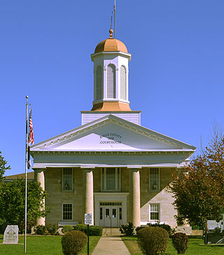
Marion County is a county located in the northeastern portion of Missouri. As of the 2020 census, the population was 28,525. Its county seat is Palmyra. Unique from most third-class counties in the state, Marion has two county courthouses, the second located in Hannibal. The county was organized on December 23, 1826 and named for General Francis Marion, the "Swamp Fox," who was from South Carolina and served in the American Revolutionary War. The area was known as the "Two Rivers Country" before organization.

Hannibal is a city along the Mississippi River in Marion and Ralls counties in the U.S. state of Missouri. According to the 2020 U.S. Census, the population was 17,312, making it the largest city in Marion County. The bulk of the city is in Marion County, with a tiny sliver in the south extending into Ralls County.
The Avenue of the Saints is a 563-mile-long (906 km) highway in the Midwestern United States that connects St. Louis, Missouri and St. Paul, Minnesota.

U.S. Route 36 (US 36) is an east–west United States highway that travels approximately 1,414 miles (2,276 km) from Rocky Mountain National Park, Colorado to Uhrichsville, Ohio. The highway's western terminus is at Deer Ridge Junction, an intersection in Rocky Mountain National Park, Colorado, where it meets US 34. Its eastern terminus is at US 250 in Uhrichsville, Ohio.

The Congressman William L. Clay Sr. Bridge, formerly known as the Bernard F. Dickmann Bridge and popularly as the Poplar Street Bridge or PSB, completed in 1967, is a 647-foot-long (197 m) deck girder bridge across the Mississippi River between St. Louis, Missouri, and East St. Louis, Illinois. The bridge arrives on the Missouri shore line just south of the Gateway Arch.
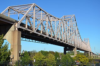
The Martin Luther King Bridge in St. Louis, Missouri, is a cantilever truss bridge of about 4,000 feet (1,200 m) in total length across the Mississippi River, connecting St. Louis with East St. Louis, Illinois. Opened in 1951, the bridge serves as traffic relief connecting the concurrent freeways of Interstate 55, Interstate 64, and U.S. Route 40 with the downtown streets of St. Louis. It was renamed for King in 1968 after the national civil rights leader was assassinated that year.

The Mark Twain Memorial Bridge is a bridge over the Mississippi River at Hannibal, Missouri, childhood home of Mark Twain, for whom the bridge is named. The bridge, north of the original bridge, was finished in 2000. The bridge carries traffic for Interstate 72 and U.S. Highway 36. The state of Missouri has put up a stone picture of Twain on the Missouri side of the bridge.

Forgottonia, also spelled Forgotonia, is the name given to a 16-county region in Western Illinois in the late 1960s and early 1970s. This geographic region forms the distinctive western bulge of Illinois that is roughly equivalent to "The Tract", the Illinois portion of the Military Tract of 1812, along and west of the Fourth Principal Meridian. Since this wedge-shaped region lies between the Illinois and Mississippi rivers, it has historically been isolated from the eastern portion of Central Illinois.
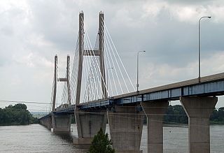
The Bayview Bridge is a cable-stayed bridge bringing westbound U.S. Route 24 (US 24) over the Mississippi River. It connects West Quincy and Quincy. Quincy Memorial Bridge serves Eastbound US-24. The bridge was built at a cost of $32 million, $3 million over budget.
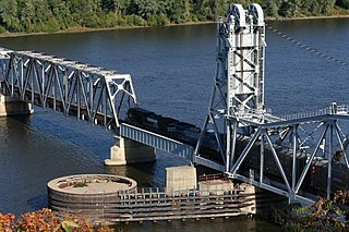
The Wabash Bridge carries one railroad track across the Mississippi River between Hannibal, Missouri, and Pike County, Illinois. Built by the Wabash Railroad, the bridge is today owned by the Norfolk Southern Railway.
The Old Clark Bridge was a bridge that carried U.S. Route 67 across the Mississippi River between West Alton, Missouri and Alton, Illinois. It was constructed beginning in 1927, was replaced by the Clark Bridge and was demolished in 1994. The bridge was initially a toll bridge.

The Mark Twain Boyhood Home & Museum is located on 206-208 Hill Street, Hannibal, Missouri, on the west bank of the Mississippi River in the United States. It was the home of Samuel Langhorne Clemens, better known as author Mark Twain, from 1844 to 1853. Clemens found the inspiration for many of his stories, including the white picket fence, while living here. It has been open to the public as a museum since 1912, and was designated a National Historic Landmark on December 29, 1962. It is located in the Mark Twain Historic District.

Mark Twain's legacy includes awards, events, a variety of memorials and namesakes, and numerous works of art, entertainment, and media.
In the U.S. state of Illinois, U.S. Route 36 (US 36) is an east–west highway that runs across the central portion of the state. It runs east from Missouri over the Mark Twain Memorial Bridge over the Mississippi River with Interstate 72. The eastern terminus of U.S. 36 in Illinois is located near the unincorporated area of Raven near the Illinois-Indiana state line. This is a distance of 216.47 miles (348.37 km).
U.S. Route 36 in the state of Missouri is an expressway with many freeway sections, connecting Kansas to Illinois. From Cameron to the Illinois state line, it forms part of the principal route between Kansas City and Chicago, known as the Chicago–Kansas City Expressway.

The Chicago–Kansas City Expressway is a highway that runs between Chicago, Illinois, and Kansas City, Missouri. The road is known as Route 110 in Missouri and Illinois Route 110 (IL 110) in Illinois. IL 110 was created through legislation on May 27, 2010, as the designated route for the Illinois portion of the Chicago–Kansas City Expressway.


