
Prince George County is a county located in the Commonwealth of Virginia. As of the 2020 census, the population was 43,010. Its county seat is Prince George.

Petersburg is an independent city in the Commonwealth of Virginia in the United States. As of the 2020 census, the population was 33,458 with a majority black American. The Bureau of Economic Analysis combines Petersburg with Dinwiddie County for statistical purposes. The city is 21 miles (34 km) south of the commonwealth (state) capital city of Richmond.

Chesterfield County is located just south of Richmond in the Commonwealth of Virginia. The county's borders are primarily defined by the James River to the north and the Appomattox River to the south. Its county seat is Chesterfield Court House.

The James River is a river in Virginia that begins in the Appalachian Mountains and flows from the confluence of the Cowpasture and Jackson Rivers in Botetourt County 348 miles (560 km) to the Chesapeake Bay. The river length extends to 444 miles (715 km) if the Jackson River is included, the longer of its two headwaters. It is the longest river in Virginia. Jamestown and Williamsburg, Virginia's first colonial capitals, and Richmond, Virginia's current capital, lie on the James River.

Monument Avenue is a tree-lined grassy mall dividing the eastbound and westbound traffic in Richmond, Virginia, originally named for its emblematic complex of structures honoring those who fought for the Confederacy during the American Civil War. Between 1900 and 1925, Monument Avenue greatly expanded with architecturally significant houses, churches, and apartment buildings. Four of the bronze statues representing J. E. B. Stuart, Stonewall Jackson, Jefferson Davis and Matthew Fontaine Maury were removed from their memorial pedestals amidst civil unrest in July 2020. The Robert E. Lee monument was handled differently as it was owned by the Commonwealth, in contrast with the other monuments which were owned by the city. Dedicated in 1890, it was removed on September 8, 2021. All these monuments, including their pedestals, have now been removed completely from the Avenue. The last remaining statue on Monument Avenue is the Arthur Ashe Monument, memorializing the African-American tennis champion, dedicated in 1996.
The Robert E. Lee Memorial Bridge in Richmond, Virginia carries U.S. Route 1 and U.S. Route 301 across the James River at the Fall Line.

Colonial Parkway is a 23-mile (37 km) scenic parkway linking the three points of Virginia's Historic Triangle, Jamestown, Williamsburg, and Yorktown. It is part of the National Park Service's Colonial National Historical Park. Virginia's official state classification for the parkway is State Route 90003. With portions built between 1930 and 1957, it links the three communities via a roadway shielded from views of commercial development. The roadway is toll-free, is free of semi trucks, and has speed limits of around 35 to 45 mph. As a National Scenic Byway and All-American Road, it is also popular with tourists due to the James River and York River ends of the parkway.
The Southside Railroad was formed in Virginia in 1846. Construction was begun in 1849 and completed in 1854. The 5 ft gauge railroad connected City Point, a port on the James River with the farm country south and west of Petersburg, Virginia, to Lynchburg, Virginia, a distance of about 132 miles (212 km).

Richmond Main Street Station, officially the Main Street Station and Trainshed, is a historic railroad station and office building in Richmond, Virginia. It was built in 1901, and is served by Amtrak. It is also an intermodal station with Richmond's city transit bus services, which are performed by Greater Richmond Transit Company (GRTC). The station is colloquially known by residents as The Clock Tower. It was listed to the National Register of Historic Places in 1970, and in 1976 was made a U.S. National Historic Landmark. Main Street Station serves as a secondary train station for Richmond providing limited Amtrak service directly to downtown Richmond. Several Amtrak trains serving the Richmond metropolitan area only stop at the area's primary rail station, Staples Mill Road which is located five miles to the north in Henrico County.
Arthur Ashe Boulevard is a historic street in the near the West End of Richmond, Virginia, providing access to Byrd Park. It serves as the border between the Carytown/Museum District to the west and the Fan district to the east. Attempts were made to rename the street after Arthur Ashe, a tennis star and social activist who was born and grew up in Richmond, but previous attempts failed until February 2019 when Richmond City Council voted in favor of changing the name to Arthur Ashe Boulevard. Near the south end is Richmond's Boulevard Bridge across the James River. Arthur Ashe Boulevard intersects with main arteries Cary Street, Main Street, Monument Avenue, Broad Street, Leigh Street, and Interstate 64/95, and terminates at Hermitage Road. The Diamond is located on Arthur Ashe Boulevard. The intersection of Arthur Ashe Boulevard and Monument Avenue featured a statue of Stonewall Jackson.
The Martin Luther King Bridge in St. Louis, Missouri, is a cantilever truss bridge of about 4,000 feet (1,200 m) in total length across the Mississippi River, connecting St. Louis with East St. Louis, Illinois. Opened in 1951, the bridge serves as traffic relief connecting the concurrent freeways of Interstate 55, Interstate 64, and U.S. Route 40 with the downtown streets of St. Louis. It was renamed for King in 1968 after the national civil rights leader was assassinated that year.

State Route 36 is a state highway in the U.S. state of Virginia. The state highway runs 16.70 miles (26.88 km) from SR 602 and SR 669 near Matoaca east to SR 10 in Hopewell. SR 36 is the main highway between Petersburg and Hopewell; within each independent city, the state highway follows a complicated path. The state highway connects those cities with Ettrick in southern Chesterfield County and Fort Gregg-Adams and Petersburg National Battlefield in Prince George County.

The Tri-Cities of Virginia is an area in the Greater Richmond Region which includes the three independent cities of Petersburg, Colonial Heights, and Hopewell and portions of the adjoining counties of Chesterfield, Dinwiddie, and Prince George in south-central Virginia. Other unincorporated communities located in the Tri-Cities area include Ettrick, Fort Gregg-Adams, and City Point, the latter formerly a historic incorporated town which was annexed to become part of the City of Hopewell.

Lower Brandon Plantation is located on the south shore of the James River in present-day Prince George County, Virginia.
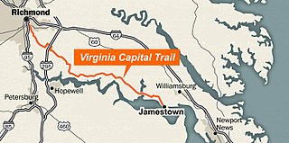
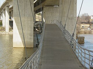
The Virginia Capital Trail (VCT) (informally, the Cap Trail, or simply the Cap) is a dedicated, paved bicycle and pedestrian trail crossing four counties and 51.7 miles (83.2 km) between Jamestown and Richmond, Virginia — that is, between the Colony of Virginia's first capital and Virginia's current capital.

The Philadelphia and Reading Railroad, Bridge at West Falls is a stone and iron plate girder bridge that is located in Philadelphia, Pennsylvania. It carries two CSX Trenton Subdivision tracks over Kelly Drive, Schuylkill River, and Martin Luther King Jr. Drive.

Rodophil is a rural unincorporated community in western Amelia County in the U.S. state of Virginia. It is located in Leigh District at the intersection of SR 616 and the southern terminus of SR 620. It straddles the border of ZIP codes 23002 and 23083. Rodophil is served by Amelia County Volunteer Fire Department Company 5, in Paineville, 3 miles northeast. A portion of the segment of U.S. Bicycle Route 1 that runs southwest from Richmond follows SR 616 through Rodophil.
The following is a timeline of the history of the city of Richmond, Virginia, United States
J. E. Greiner Company was a Baltimore, Maryland-based civil engineering firm specializing in bridge design.
