Maryland City, Maryland

Last updated

Maryland City, Maryland
Anne Arundel County Maryland Incorporated and Unincorporated areas Maryland City Highlighted.svg
Location within Anne Arundel County
USA Maryland location map.svg
Red pog.svg
Maryland City
Location within the State of Maryland
Coordinates: 39°5′33″N76°49′10″W / 39.09250°N 76.81944°W / 39.09250; -76.81944
CountryFlag of the United States.svg  United States
State Flag of Maryland.svg  Maryland
County Flag of Anne Arundel County, Maryland.png Anne Arundel
Area
[1]
  Total7.71 sq mi (19.98 km2)
  Land7.71 sq mi (19.98 km2)
  Water0.00 sq mi (0.00 km2)
Elevation
207 ft (63 m)
Population
 (2020)
  Total19,153
  Density2,483.21/sq mi (958.72/km2)
Time zone UTC−05:00 (Eastern)
  Summer (DST) UTC−04:00 (Eastern)
ZIP Code
20724
Area code(s) 301 and 240
FIPS code 24-51075
GNIS feature ID 0590752

Maryland City is a census-designated place (CDP) in Anne Arundel County, Maryland, United States. The population was 16,093 at the 2010 census. [2] It is located east of Laurel, just over the border with Prince George's County, and it has a Laurel ZIP Code. Maryland City mostly consists of an older, compact housing development and is adjacent to Fort Meade army base. A large newer development (built mid-1990s) on the north side of Maryland Route 198 is known as Russett and is included within the Maryland City CDP.

Contents

Services

Maryland City is home to the Maryland City Volunteer Fire Department, which is part of the Anne Arundel County Fire Department. MCVFD Station 27 is located at 3498 Laurel Fort Meade Road. It is staffed 24 hours a day by four career firefighters, one of whom is an EMT-paramedic.[ citation needed ] The career staff is supplemented by volunteers.

History

Maryland City was developed by the Maryland City Corp, owned by developer Harvey Kayne. The 1,200 acres (490 ha) of eastern Laurel, Maryland, were purchased in 1960 for $3 million from a developer planning "Meade City". The concept was to build low-cost houses with ground-rent rather than ownership. [3]

Geography

Maryland City is located at 39°05′38″N76°49′05″W / 39.09389°N 76.81806°W / 39.09389; -76.81806 (39.092561, 76.819419) in the westernmost corner of Anne Arundel County. It is bordered by Laurel in Prince George's County to the west, by the CDP of Scaggsville in Howard County to the north, by the CDP of Jessup to the northeast, and by Fort Meade to the east. Uninhabited portions of Fort Meade are to the south.

The Baltimore–Washington Parkway (Maryland Route 295) runs through the CDP, leading southwest 19 miles (31 km) to downtown Washington and 18 miles (29 km) northeast to downtown Baltimore. Access from the parkway to Maryland City is via Maryland Route 198 (Fort Meade Road). Maryland Route 32 (the Patuxent Freeway) forms the northeast edge of the CDP.

According to the United States Census Bureau, the CDP has a total area of 7.7 square miles (20.0 km2), all land. [2]

Demographics

Historical population
CensusPop.Note
2020 19,153
U.S. Decennial Census [4]

2010

Population by Race in Maryland City, Maryland (2010)
RacePopulation % of Total
Total16,093100
African American 6,77242
White 6,27238
Hispanic 2,15113
Asian 1,3338
Other 1,0056
Two or More Races 6634
[5]

2000

As of the census [6] of 2000, there were 6,814 people, 2,575 households, and 1,732 families residing in the CDP. The population density was 2,603.3 people per square mile (1,004.2/km2). There were 2,666 housing units at an average density of 1,018.5/sq mi (392.9/km2). The racial makeup of the CDP was 62.93% White, 26.58% African American, 0.50% Native American, 5.27% Asian, 0.03% Pacific Islander, 1.94% from other races, and 2.76% from two or more races. Hispanic or Latino of any race were 4.95% of the population.

There were 2,575 households, out of which 33.3% had children under the age of 18 living with them, 47.5% were married couples living together, 13.8% had a female householder with no husband present, and 32.7% were non-families. 24.6% of all households were made up of individuals, and 3.9% had someone living alone who was 65 years of age or older. The average household size was 2.62 and the average family size was 3.13.

In the CDP, the population was spread out, with 26.5% under the age of 18, 8.8% from 18 to 24, 37.3% from 25 to 44, 19.8% from 45 to 64, and 7.6% who were 65 years of age or older. The median age was 33 years. For every 100 females, there were 95.6 males. For every 100 females age 18 and over, there were 94.0 males.

The median income for a household in the CDP was $51,849, and the median income for a family was $55,754. Males had a median income of $38,879 versus $33,424 for females. The per capita income for the CDP was $23,259. About 2.1% of families and 3.6% of the population were below the poverty line, including 1.4% of those under age 18 and 4.3% of those age 65 or over.

Related Research Articles

<span class="mw-page-title-main">Brooklyn Park, Maryland</span> Census-designated place in Maryland, United States

Brooklyn Park is a census-designated place (CDP) in Anne Arundel County, Maryland, United States. The population was 14,373 at the 2010 census.

<span class="mw-page-title-main">Cape St. Claire, Maryland</span> Census-designated place in Maryland, United States

Cape St. Claire, a suburb of Annapolis, is a covenanted, unincorporated community as well as a census-designated place (CDP) in Anne Arundel County, Maryland, United States. While the community of Cape St. Claire lies entirely within the CDP and accounts for approximately 80% of the homes and residents, the CDP also includes the smaller communities of Atlantis, Walnut Ridge, Green Holly, and St. Claire Court. The population of the CDP was 8,747 at the 2010 census.

<span class="mw-page-title-main">Crownsville, Maryland</span> Census-designated place in Maryland, United States

Crownsville is a census-designated place (CDP) in Anne Arundel County, Maryland, United States. The population was 1,757 at the 2010 census. It hosts the Anne Arundel County Fair each September, as well as the annual Maryland Renaissance Festival for several summer weekends. A state psychiatric hospital was formerly in Crownsville. The area offers waterfront scenery and easy access to urban metropolitan areas and culture.

<span class="mw-page-title-main">Ferndale, Maryland</span> Census-designated place in Maryland, United States

Ferndale is a census-designated place (CDP) in Anne Arundel County, Maryland, United States. At the 2010 census, the population was 16,746.

<span class="mw-page-title-main">Fort Meade, Maryland</span> Census-designated place in Maryland, United States

Fort Meade is a census-designated place (CDP) in Anne Arundel County, Maryland, United States. The population was 9,327 at the 2010 census. It is the home to the National Security Agency, Central Security Service, United States Cyber Command and the Defense Information Systems Agency, which are located on the U.S. Army post Fort George G. Meade.

<span class="mw-page-title-main">Lake Shore, Maryland</span> Census-designated place in Maryland, United States

Lake Shore is a census-designated place and unincorporated community in Anne Arundel County, Maryland, United States, located east of Pasadena. The population of Lake Shore was 19,477 at the 2010 census.

<span class="mw-page-title-main">Linthicum, Maryland</span> Census-designated place in Maryland, United States

Linthicum is a census-designated place (CDP) and unincorporated community in Anne Arundel County, Maryland, United States. The population was 10,324 at the 2010 census. It is located directly north of Baltimore–Washington International Thurgood Marshall Airport (BWI).

<span class="mw-page-title-main">Odenton, Maryland</span> Census-designated place in Maryland, U.S.

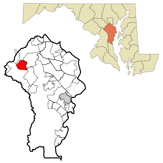
Odenton is a census-designated place (CDP) in Anne Arundel County, Maryland, United States, located approximately 10–20 minutes from the state capital, Annapolis. The population was 37,132 at the 2010 census, up from 20,534 at the 2000 census. The town's population growth rate of 80.8% between 2000 and 2010 was the greatest of any town in western Anne Arundel County. Odenton is located west of Annapolis, south of Baltimore, and northeast of Washington.

<span class="mw-page-title-main">Parole, Maryland</span> Census-designated place in Maryland, United States

Parole, a suburb of Annapolis, is a census-designated place (CDP) in Anne Arundel County, Maryland, United States. The population was 15,922 at the 2010 census. It has several major roads intersect at the western edge of the state capital, Annapolis, and it contains the Annapolis Mall, a number of other large shopping centers, and the Anne Arundel Medical Center. It is generally considered to be part of Annapolis, rather than a separate town. The neighborhood was named because it was a parole camp, where Union and Confederate prisoners of war were brought for mutual exchange and eventual return to their respective homes.

<span class="mw-page-title-main">Pasadena, Maryland</span> Census-designated place in Maryland, United States

Pasadena is a census-designated place (CDP) in Anne Arundel County, Maryland, United States. The population was 24,287 at the 2010 census.

<span class="mw-page-title-main">Pumphrey, Maryland</span> Unincorporated community in Maryland, United States

Pumphrey is an unincorporated community and former census-designated place (CDP) in Anne Arundel County, Maryland, United States. At the 2000 census, the population was 5,317. It was split between the Linthicum and Brooklyn Park CDPs for the 2010 census.

<span class="mw-page-title-main">Severn, Maryland</span> Census-designated place in Maryland, United States

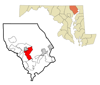
Severn is a census-designated place (CDP) in Anne Arundel County, Maryland, United States. According to the 2020 U.S. census, the population of Severn is 57,118, a 22.6% increase from 44,231 in 2010. The zip code is 21144.

<span class="mw-page-title-main">Severna Park, Maryland</span> Census-designated place in Maryland, United States

Severna Park is a census-designated place (CDP) in Anne Arundel County, Maryland, United States. Severna Park is part of the Baltimore-Washington Metropolitan Area, and is located approximately 8 miles (13 km) north of Annapolis, 17 miles (27 km) south of Baltimore and 39 miles (63 km) east of Washington, D.C. Severna Park's population was 39,933 at the 2020 census.

<span class="mw-page-title-main">Shady Side, Maryland</span> Census-designated place in Maryland, United States

Shady Side is a census-designated place (CDP) in Anne Arundel County, Maryland, United States. The population was 5,803 at the 2010 census.

<span class="mw-page-title-main">South Gate, Maryland</span> Former census-designated place in Maryland, United States

South Gate was a census-designated place (CDP) in Anne Arundel County, Maryland, United States, for the 2000 census, at which time its population was 28,672. It was added primarily to the Glen Burnie CDP for the 2010 census.

<span class="mw-page-title-main">Bel Air South, Maryland</span> Census-designated place in Maryland, United States

Bel Air South is a census-designated place (CDP) in Harford County, Maryland, United States. The population was 47,709 at the 2010 census, up from 39,711 in 2000.

<span class="mw-page-title-main">South Laurel, Maryland</span> Census-designated place in Maryland

South Laurel is an unincorporated area and census-designated place (CDP) in Prince George's County, Maryland, United States. Per the 2020 census, the population was 29,602.

<span class="mw-page-title-main">West Laurel, Maryland</span> Census-designated place in Maryland

West Laurel is an unincorporated area and census-designated place (CDP) in Prince George's County, Maryland, United States. Per the 2020 census, the population was 4,428.

<span class="mw-page-title-main">Jessup, Maryland</span> Census-designated place in Maryland

Jessup is an unincorporated community and census-designated place in Howard and Anne Arundel counties, about 15 miles (24 km) southwest of Baltimore, Maryland, United States. Per the 2020 census, the population was 10,535.

<span class="mw-page-title-main">Baltimore Highlands, Maryland</span> Census-designated place in Maryland, United States

Baltimore Highlands is a census-designated place (CDP) in Baltimore County, Maryland, United States, directly south of the city of Baltimore. The population was 7,019 at the 2010 census. At the 2000 census and earlier, the area was delineated as part of the Lansdowne-Baltimore Highlands CDP.

References

  1. "2020 U.S. Gazetteer Files". United States Census Bureau. Retrieved April 26, 2022.
  2. 1 2 "Geographic Identifiers: 2010 Demographic Profile Data (G001): Maryland City CDP, Maryland". U.S. Census Bureau, American Factfinder. Archived from the original on February 12, 2020. Retrieved May 31, 2013.
  3. "5000 Homes planned near Laurel, Maryland". The Washington Post. August 4, 1960.
  4. "Census of Population and Housing". Census.gov. Retrieved June 4, 2016.
  5. "Maryland City Maryland Population Statistics". US Census Bureau. Retrieved June 9, 2014.
  6. "U.S. Census website". United States Census Bureau . Retrieved January 31, 2008.