
Transportation in Botswana is provided by an extensive network of railways, highways, ferry services and air routes that criss-cross the country. The transport sector in Botswana played an important role in economic growth following its independence in 1966. The country discovered natural resources which allowed it to finance the development of infrastructure, and policy ensured that the transport sector grew at an affordable pace commensurate with demands for services.

The Kariba Dam is a double curvature concrete arch dam in the Kariba Gorge of the Zambezi river basin between Zambia and Zimbabwe. The dam stands 128 metres (420 ft) tall and 579 metres (1,900 ft) long. The dam forms Lake Kariba, which extends for 280 kilometres (170 mi) and holds 185 cubic kilometres (150,000,000 acre⋅ft) of water.

Victoria Falls is a waterfall on the Zambezi River in southern Africa, which provides habitat for several unique species of plants and animals. It is located on the border between Zambia and Zimbabwe and is one of the world's largest waterfalls, with a width of 1,708 m (5,604 ft).

Lake Kariba is the world's largest artificial lake and reservoir by volume. It lies 1,300 kilometres (810 mi) upstream from the Indian Ocean, along the border between Zambia and Zimbabwe. Lake Kariba was filled between 1958 and 1963 following the completion of the Kariba Dam at its northeastern end, flooding the Kariba Gorge on the Zambezi River.

Matabeleland is a region located in southwestern Zimbabwe that is divided into three provinces: Matabeleland North, Bulawayo, and Matabeleland South. These provinces are in the west and south-west of Zimbabwe, between the Limpopo and Zambezi rivers and are further separated from Midlands by the Shangani River in central Zimbabwe. The region is named after its inhabitants, the Ndebele people who were called "Amatabele"(people with long spears – Mzilikazi 's group of people who were escaping the Mfecani wars). Other ethnic groups who inhabit parts of Matabeleland include the Tonga, Bakalanga, Venda, Nambya, Khoisan, Xhosa, Sotho, Tswana, and Tsonga.
Colleen Bawn is a town in Zimbabwe.
Mangrove Creek Dam, a concrete faced rockfill embankment dam, is the primary reservoir for water supply to residents of the Central Coast in New South Wales, Australia.

The First Matabele War was fought between 1893 and 1894 in modern-day Zimbabwe. It pitted the British South Africa Company against the Ndebele (Matabele) Kingdom. Lobengula, king of the Ndebele, had tried to avoid outright war with the company's pioneers because he and his advisors were mindful of the destructive power of European-produced weapons on traditional Matabele impis attacking in massed ranks. Lobengula reportedly could muster 80,000 spearmen and 20,000 riflemen, armed with Martini-Henry rifles, which were modern arms at that time. However, poor training meant that these were not used effectively.

Lupane ( luːpɑːnɛ) District is located in the Matabeleland North Province of Zimbabwe, and it is also the Provincial Capital. The District is situated at an elevation of 976 m with a population of 198,600 inhabitants by 2019. Lupane Town is the main center of the district located 172 km from Bulawayo along the A8 Victoria Falls Road. The Government Provincial Administrative offices are located at the Town Centre. A new university near the Town has been established under the name Lupane State University, which caters for the region and beyond. The word Lupane is thought to be a Kalanga or Lozwi word.
The Mzingwane River, formerly known Umzingwane River as or Umzingwani River is a major left-bank tributary of the Limpopo River in Zimbabwe. It rises near Fort Usher, Matobo District, south of Bulawayo and flows into the Limpopo River near Beitbridge, downstream of the mouth of the Shashe River and upstream of the mouth of the Bubye River.

Split Rock Dam is a minor ungated concrete faced rock fill embankment dam with concrete chute spillway across the Manilla River upstream of Manilla in the north-western slopes region of New South Wales, Australia. The dam's purpose includes flood mitigation, irrigation, water supply and conservation. The impounded reservoir is called Split Rock Reservoir.

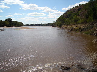
The Shashe River is a major left-bank tributary of the Limpopo River in Zimbabwe. It rises northwest of Francistown, Botswana and flows into the Limpopo River where Botswana, Zimbabwe and South Africa meet. The confluence is at the site of the Greater Mapungubwe Transfrontier Conservation Area.

The Faraya-Chabrouh Dam is a dam above the village of Faraya Lebanon, 40 kilometers northeast of Beirut that was inaugurated in 2007. The dam has a height of 63 metres. The reservoir has a capacity of some 8 million cubic meters and is some 1300 metres in length.
The Dikgatlhong Dam is a dam near the village of Robelela on the Shashe River in Botswana, completed in December 2011. When full it will hold 400,000,000 cubic metres (1.4×10¹⁰ cu ft). The next largest dam in Botswana, the Gaborone Dam, has capacity of 141,000,000 cubic metres (5.0×10⁹ cu ft).

The North-South Carrier (NSC) is a pipeline in Botswana that carries raw water south for a distance of 360 kilometres (220 mi) to the capital city of Gaborone. Phase 1 was completed in 2000. Phase 2 of the NSC, under construction, will duplicate the pipeline to carry water from the Dikgatlhong Dam, which was completed in 2012. A proposed extension to deliver water from the Zambezi would add another 500 to 520 kilometres to the total pipeline length. The NSC is the largest engineering project ever undertaken in Botswana.

The Zambezi River Authority (ZRA) is a corporation jointly and equally owned by the governments of Zambia and Zimbabwe.
Moralane is a key site on the North-South Carrier (NSC), in Botswana, the main pipeline delivering raw water from the northeast to the Mmamashia water treatment plant just north of Gaborone.

Mutange Dam, across Mutange River, is a manmade earth fill embarkment dam located in Chisina Village, 30 km east of Gokwe and 35 km northwest of Empress Mine, in the Midlands Province of Zimbabwe. Mutange Dam is 42 km by road from Gokwe and 49 km from Empress, 117 km from Kadoma and 146 km from Kwekwe via Empress. It is owned and operated by the Ministry of Water Resources and Development.
The Colleen Bawn Solar Power Station is a 32 MW (43,000 hp) solar power plant under development in Zimbabwe. The project is owned by Pretoria Portland Cement Limited, who own a cement factory in Colleen Bawn and plan to consume 16 megawatts of the electricity generated and sell the rest to the Zimbabwe national grid.
The Shangani Solar Power Station is a proposed 25 megawatts solar power plant in Zimbabwe. The project is under development by a Zimbabwean independent power producer (IPP), called Shangani Renewable Energy. It is expected that when this power station begins commercial operations, the energy generated here will be sold to the Zimbabwe Electricity Supply Authority (ZESA), for integration into the national grid.


