The Matthew Jones House is a historic plantation house located on Fort Eustis in Newport News, Virginia. The house sits on a hill toward the northern end of Mulberry Island, overlooking the James River. It was built ca. 1725 as a one-and-a-half-story frame dwelling with brick chimneys and later underwent two major renovations. During the first renovation, in 1730, the walls were bricked in and a shed room and porch tower were added. During the second, in 1893, the house was raised to a full two stories. In 1918 the house and its surrounding land were acquired by the U.S. government for the establishment of an army post. By the late twentieth century, the Matthew Jones House had fallen into grave disrepair. In 1993 it was preserved and rehabilitated by the National Park Service in cooperation with the U.S. Army Corps of Engineers. Today it serves as an architectural museum.
At times in the past the Matthew Jones House was also known as the "Brick House" for its construction, and the nearby creek, now known as Milstead Creek, was once called Brick House Creek. It is frequently stated in popular histories of the area and on the Matthew Jones House roadside historical marker that the plantation was once known as "Bourbon".
Period I (ca. 1725)
The Matthew Jones House, named after its original owner, was built around 1725 as a 11⁄2-story frame house with brick chimneys. The house in its earliest form was earthfast – rather than the house standing on a foundation, its main structural posts extended into the ground. The original form of the house was a two-room hall and parlor style dwelling,[3] with the hall serving as a multipurpose living and working room and the parlor, or chamber, used for sleeping and private dining.
Matthew Jones died in 1728 and left his house to his son Scervant, who was a minor at the time. Scervant's guardian, John Jones, embarked on improvements to the house which had probably been planned by Matthew before his death. The exterior walls of the house were rebuilt in brick,[4] though several beams from the earlier framing were retained as part of the roof framing and have survived to this day.[5] The house also acquired a cellar at this time and was no longer earthfast, but rather had a brick foundation. The foundation was laid in English bond, while brickwork in the rest of the house was laid using Flemish bond. Several decorative elements are present in the brickwork: the headers of the bricks are glazed, and rubbed bricks were used around the windows and at the corners of the building.
Southeast elevation of the Matthew Jones House, showing the Period II porch tower and shed room additions.
Two additions were made to the house at this time: a shed room at the back of the building and a two-story porch tower at the front.[4] The shed room provided additional sleeping or storage space, while the new tower entry provided a measure of control over who had access to the interior, private spaces of the house. In the second quarter of the eighteenth century, central passages were becoming commonly used for this purpose.[6] The Joneses likely built the porch tower, a more old-fashioned architectural feature, rather than a central passage because there was not enough space within the existing plan of the house to insert a passage without making the size of the rooms to either side inconveniently small.[7]
Dendrochronological testing of several of the timbers from this period of renovation revealed that the trees used were felled in 1729 and were used soon after they were cut down, probably in 1730.[8][9]
Period III (1893)
The Matthew Jones House underwent extensive remodeling in 1893. At that time the exterior kitchen was demolished and its bricks used to raise the house to a full two stories. Bricks with the inscription "Matthew Jones 1727," which had formerly been part of the kitchen, were placed on the façade at the base of the new second story. In contrast with the original brickwork, the bricks of the new addition were laid in seven-course American bond. The outline of the original roof is still visible at each end of the building, more steeply pitched than the current roof. To accommodate the new, higher roofline, the original chimneys were heightened by adding twin stacks to the top of each. The windows were replaced, and a second door was cut into the east wall of the house, which eventually led to a frame addition which was built sometime between 1893 and the 1910s. This addition was present when photographs were taken in the 1930s but has since been demolished.[10]
"Matthew Jones 1727" inscription on the front of the house.
In 1918 the U.S. government purchased Mulberry Island and the surrounding land in order to establish an army post known as Camp Eustis, now Fort Eustis. The Matthew Jones House was among the properties acquired at this time. The Army used the building as post housing for several decades. After World War II, the house was abandoned and sat vacant for years.
In 1940, a project to measure and record the Matthew Jones House was undertaken as part of the Historic American Buildings Survey (HABS). Drawings of all four elevations and floor plans of the first and second floors and of the cellar were produced, and ten photographs of the exterior were taken. A HABS inventory form was completed in 1959.[11] In April 1969 the house was declared a Virginia Historic Landmark, and in June of the same year it was placed on the National Register of Historic Places.[12]
Period IV (1993 - )
By the late twentieth century, the house was noticeably deteriorating. Members of the Fort Eustis Historical and Archaeological Association took notice and urged the Army to take steps to preserve it.[13] In 1993, personnel from the National Park Service's Williamsport Preservation Training Center (WPTC), using funding provided by the Norfolk office of the U.S. Army Corps of Engineers, undertook a project to halt the decline of the house. The primary objective of this project was the stabilization and preservation of the building, with a secondary goal of providing the opportunity for visitors to see the building techniques that were used in the past.
The exterior of the house was restored to its Period III appearance.[14]
Interior view of the Matthew Jones House, showing an exposed Period I beam
In order to facilitate the second objective, it was decided to leave the interior of the building in a state of "semi-ruin," with architectural elements exposed. All Period I and II elements were left intact, while Period III elements were repaired if possible or replaced, and twentieth-century features were removed.
Today the house is managed by the Fort Eustis Cultural Resources program.
↑ Graham, Willie, William J. Davis, Donald W. Linebaugh, Leslie McFaden, and Vanessa Patrick 1991 A Preservation Plan for the Matthew Jones House, Fort Eustis, Virginia. William and Mary Center for Archaeological Research, Williamsburg, Virginia. Submitted to Telemarc, Inc., Vienna, Virginia. p. 35
1 2 3 Graham, Willie, William J. Davis, Donald W. Linebaugh, Leslie McFaden, and Vanessa Patrick 1991 A Preservation Plan for the Matthew Jones House, Fort Eustis, Virginia. William and Mary Center for Archaeological Research, Williamsburg, Virginia. Submitted to Telemarc, Inc., Vienna, Virginia. p. 44
↑ Fort Eustis Cultural Resources 2014 The Matthew Jones House. Pamphlet produced by Fort Eustis Cultural Resources, pp.11-13
↑ Graham, Willie, William J. Davis, Donald W. Linebaugh, Leslie McFaden, and Vanessa Patrick 1991 A Preservation Plan for the Matthew Jones House, Fort Eustis, Virginia. William and Mary Center for Archaeological Research, Williamsburg, Virginia. Submitted to Telemarc, Inc., Vienna, Virginia. p. 42
↑ Graham, Willie, William J. Davis, Donald W. Linebaugh, Leslie McFaden, and Vanessa Patrick 1991 A Preservation Plan for the Matthew Jones House, Fort Eustis, Virginia. William and Mary Center for Archaeological Research, Williamsburg, Virginia. Submitted to Telemarc, Inc., Vienna, Virginia. p. 52
↑ Heikkenen, Herman J. et al. 1984 The Last Year of Tree Growth for Selected Timbers Within the Matthew Jones House as Derived by the Key-Year Dendrochronology Technique. American Institute of Dendrochronology, Blacksburg, Virginia.
↑ Heikkenen, Herman J. et al. 1986 The Last Year of Tree Growth for Selected Timbers Within the Tower and Attic of the Matthew Jones House as Derived by the Key-Year Dendrochronology Technique. American Institute of Dendrochronology, Blacksburg, Virginia.
↑ Graham, Willie, William J. Davis, Donald W. Linebaugh, Leslie McFaden, and Vanessa Patrick 1991 A Preservation Plan for the Matthew Jones House, Fort Eustis, Virginia. William and Mary Center for Archaeological Research, Williamsburg, Virginia. Submitted to Telemarc, Inc., Vienna, Virginia. pp. 57-58
↑ Graham, Willie, William J. Davis, Donald W. Linebaugh, Leslie McFaden, and Vanessa Patrick 1991 A Preservation Plan for the Matthew Jones House, Fort Eustis, Virginia. William and Mary Center for Archaeological Research, Williamsburg, Virginia. Submitted to Telemarc, Inc., Vienna, Virginia. p. 2
The Jamestown settlement in the Colony of Virginia was the first permanent English settlement in the Americas. It was located on the northeast bank of the James (Powhatan) River about 2.5 mi (4 km) southwest of the center of modern Williamsburg. It was established by the Virginia Company of London as "James Fort" on May 4, 1607 O.S., and was considered permanent after a brief abandonment in 1610. It followed several failed attempts, including the Lost Colony of Roanoke, established in 1585 on Roanoke Island, later part of North Carolina. Jamestown served as the colonial capital from 1616 until 1699.
Jamestown Settlement is a living history museum operated by the Commonwealth of Virginia, created in 1957 as Jamestown Festival Park for the 350th anniversary celebration. Today it includes a recreation of the original James Fort, a Powhatan Native American Town, indoor and outdoor displays, and replicas of the original settlers' ships the Susan Constant, Godspeed, and Discovery.
James City County is a county located in the Commonwealth of Virginia. As of the 2010 census, the population was 67,009. Although politically separate from the county, the county seat is the adjacent independent city of Williamsburg.
Colonial Williamsburg is a living-history museum and private foundation presenting a part of the historic district in the city of Williamsburg, Virginia, United States.
Founded in 1889, the Association for the Preservation of Virginia Antiquities was the United States' first statewide historic preservation group. In 2003 the organization adopted the new name APVA Preservation Virginia to reflect a broader focus on statewide Preservation and in 2009 it shortened its name to Preservation Virginia. Preservation Virginia owns historic sites across Virginia including Historic Jamestowne, located at Jamestown, Virginia, site of the first permanent English settlement in North America, and the Cape Henry Light, one of the first public works projects of the United States of America.
Bruton Parish Church is located in the restored area of Colonial Williamsburg in Williamsburg, Virginia, United States. It was established in 1674 by the consolidation of two previous parishes in the Virginia Colony, and remains an active Episcopal parish. The building, constructed 1711–15, was designated a National Historic Landmark in 1970 as a well-preserved early example of colonial religious architecture.
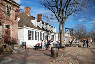
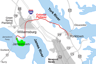
The Historic Triangle includes three historic colonial communities located on the Virginia Peninsula of the United States and is bounded by the York River on the north and the James River on the south. The points that form the triangle are Jamestown, Colonial Williamsburg, and Yorktown. They feature many restored attractions and are linked by the Colonial Parkway in James City and York counties, and the City of Williamsburg.
The Wren Building is the signature building of the College of William & Mary in Williamsburg, Virginia, USA. Along with the Brafferton and President's House, these buildings form the College's Ancient Campus. With a construction history dating to 1695, it is the oldest academic building in continuous use in the United States. It was designated a National Historic Landmark in 1960.
The Governor's Palace in Williamsburg, Virginia was the official residence of the Royal Governors of the Colony of Virginia. It was also a home for two of Virginia's post-colonial governors, Patrick Henry and Thomas Jefferson, until the capital was moved to Richmond in 1780, and with it the Governor's residence. The main house burned down in 1781, though the outbuildings survived for some time after.
Carter's Grove, also known as Carter's Grove Plantation, is a 750-acre (300 ha) plantation located on the north shore of the James River in the Grove Community of southeastern James City County in the Virginia Peninsula area of the Hampton Roads region of Virginia in the United States.
Historic Jamestown is the cultural heritage site that was the location of the 1607 James Fort and the later 17th-century town of Jamestown in America. It is located on Jamestown Island, on the James River at Jamestown, Virginia and operated as a partnership between Preservation Virginia and the U.S. National Park Service as part of Colonial National Historical Park.
Donald W. Linebaugh is an American archaeologist and author.
Historic paint analysis is the scientific analysis of architectural finishes, including not only paints but also metallic finishes and clear and translucent finishes used on historic buildings. The primary purpose of such analysis is to determine the color of the finish used at a particular time in the building's history, usually the original construction, but not always. Secondary purposes include determination of ingredients such as media and pigments. Paint analysis is also used at times as a dating technique for various building elements.
Jamestown Church, constructed in brick from 1639 onward, in Jamestown in the Mid-Atlantic state of Virginia, is one of the oldest surviving building remnants built by Europeans in the original thirteen colonies and in the United States overall. It is now part of Historic Jamestowne, and is owned by Preservation Virginia. There have been several sites and stages in the church's history, and its later tower is now the last surviving above-ground structure from the days when Jamestown was the capital of Virginia. The current structure, active as part of the Anglican church, is still in use today. The ruins are currently being researched by members of the Jamestown Rediscovery project.
The Peninsula Extension which created the Peninsula Subdivision of the Chesapeake and Ohio Railway (C&O) was the new railroad line on the Virginia Peninsula from Richmond to southeastern Warwick County. Its principal purpose was to provide an important new pathway for coal mined in West Virginia to reach the harbor of Hampton Roads for coastal and export shipping on collier ships.
48 Hudson Avenue is the oldest building in the city of Albany, New York. It was believed by Paul Huey, in the Albany architectural guide of 1993, to have been built in 1759 by Johannes Radliff when he married Elizabeth Singleton because he believed it was built after the stockade was moved south by one block. Research done by Albany historian John Wolcott proved that it had been occupied by Johannes van Ostrande between 1728 and 1734 and that a mortgage Radliff had on the house referred to it as "formerly van Ostrande." The Lamont-Doherty Earth Sciences laboratory of Columbia University performed dendrochronology on a wood core sample from the building to confirm that the building dated from 1728. It has been listed on the National Register of Historic Places since January 10, 2008; prior to that, it had been a contributing property to the Downtown Albany Historic District.
Pear Valley is a one-room yeoman's cottage and prime example of vernacular architecture in Eastville, Virginia. The modest embellishments and its high level of preservation make it one of the most architecturally interesting examples of small, historic homes in Virginia.
Kentland Farm Historic and Archeological District is a historic home, archaeological site, and national historic district located near Blacksburg, Montgomery County, Virginia. The district encompasses a complex of 19th century agricultural outbuildings associated with a Federal and Greek Revival style brick dwelling built 1834–1835. Located in the district are significant archaeological resources that include a complex of Late Woodland village or camp sites.
Fort Crafford is a historic archaeological site located at Fort Eustis, Newport News, Virginia. It is a pentagonal-shaped earthwork located on Mulberry Island and built by Confederate forces in 1862. The earthworks on Mulberry Island are considered part of the Warwick Line. The purpose of these works was to prevent the Union from flanking the line on the James River. The fort formed the James River terminus of the second trans-peninsula defensive line, which included fortifications at Lee's Mill, as well as Dam No.1 and Wynne's Mill in Newport News Park.
This page is based on this Wikipedia article Text is available under the CC BY-SA 4.0 license; additional terms may apply. Images, videos and audio are available under their respective licenses.