Kirkwood is a national historic designated neighborhood on the east side of Atlanta, Georgia, United States. It is a historic streetcar suburb situated entirely in DeKalb County, bordered by the neighborhoods of Lake Claire, East Lake, Edgewood, and Oakhurst. Kirkwood is bound on the north by DeKalb Avenue, on the south by Memorial Drive and Interstate 20, on the west by Montgomery Street, and on the east by 1st Ave. A large part of the neighborhood is listed on the National Register of Historic Places as Kirkwood Historic District.

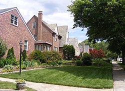
Bolton Hill is a neighborhood in Baltimore, Maryland, with 20 blocks of mostly preserved buildings from the late 19th century. It is listed on the National Register of Historic Places, preserved as a Baltimore City Historic District, and included within the boundaries of Baltimore National Heritage Area. The neighborhood is bounded by North Avenue, Mount Royal Avenue, Cathedral Street, Dolphin Street, and Eutaw Place. Bolton Hill is a largely residential neighborhood with three-story row houses with red brick, white marble steps, and high ceilings. There are also larger more ornate originally single-family houses, many houses of worship, parks, monuments, and a few large apartment buildings. Many significant residents have lived in the neighborhood, including F. Scott Fitzgerald, Woodrow Wilson, the Cone sisters, and Florence Rena Sabin.
Roland Park is a community located in Baltimore, Maryland. It was developed between 1890 and 1920 as an upper-class streetcar suburb. The early phases of the neighborhood were designed by Edward Bouton and Frederick Law Olmsted Jr.

Clifton is is one of the 52 neighborhoods of Cincinnati, Ohio. The population was 8,408 in the 2020 census.

Maryland Route 41 is a state highway in the U.S. state of Maryland. Known for most of its length as Perring Parkway, the state highway runs 6.75 miles (10.86 km) from MD 147 in Baltimore north to Waltham Woods Road in Carney. MD 41 is a four- to six-lane divided highway that connects portions of Northeast Baltimore, including Morgan State University, with Parkville and Interstate 695 (I-695). The state highway is maintained by the Maryland State Highway Administration in Baltimore County and the Baltimore City Department of Transportation in the city, where it is unsigned. MD 41 was built in the early to mid-1960s, largely to relieve congestion on portions of neighboring Old Harford and Harford Roads during the period of rapid post-World War II growth in the area.

Maryland Route 147 is a state highway in the U.S. state of Maryland. Known as Harford Road, the state highway runs 18.82 miles (30.29 km) from U.S. Route 1 and US 40 Truck in Baltimore north to US 1 and US 1 Business in Benson. MD 147 is an alternate route to US 1 between Baltimore and Bel Air, the county seat of Harford County. The state highway is the main street of several neighborhoods in Northeast Baltimore and the Baltimore County suburbs of Parkville and Carney. MD 147 is maintained by the Maryland State Highway Administration in Baltimore and Harford counties and by the Baltimore City Department of Transportation within the city. Harford Road was a pair of turnpikes before the Baltimore–Carney portion of the highway was designated one of the original state roads. The Baltimore County section of MD 147 was constructed in the early 1910s and widened multiple times in the late 1920s and 1930s. The section of the state highway in Harford County was built in the late 1920s.

Hamilton Hills is a mixed-use suburban neighborhood located in the northeastern corner of Baltimore City, Maryland. Hamilton Hills represents a section of Hamilton, a larger historic area that includes other neighborhoods in Northeast Baltimore. The neighborhood's borders are Old Harford Road and Harford Road to the east, Echodale Avenue to the south, Perring Parkway to the west and the Baltimore County line to the north. The main thoroughfare in Hamilton Hills is Harford Road, which has been an integral part of the area's history.

Heritage High School was a public high school located in the northeast area known as Clifton Park of Baltimore, Maryland, United States. It served Baltimore City high schoolers from 2004 to 2015.

The Coldstream-Homestead-Montebello community, often abbreviated to C-H-M, is a neighborhood in northeastern Baltimore, Maryland. A portion of the neighborhood has been listed on the National Register of Historic Places as the Coldstream Homestead Montebello Historic District, recognized for the development of a more suburban style of rowhouses.

Clifton Park is a public urban park and national historic district located between the Coldstream-Homestead-Montebello and Waverly neighborhoods to the west and the Belair-Edison, Lauraville, Hamilton communities to the north in the northeast section of Baltimore, Maryland, United States. It is roughly bordered by Erdman Avenue to the northeast, Sinclair Lane to the south, Harford Road to the northwest and Belair Road to the southeast. The eighteen-hole Clifton Park Golf Course, which is the site of the annual Clifton Park Golf Tournament, occupies the north side of the park.

East Baltimore Midway is a neighborhood in the Eastern district of Baltimore, Maryland. Its boundaries are the south side of 25th Street, the east side of Greenmount Avenue, the west side of Harford Road, and the north side of North Avenue.

Lauraville is a neighborhood in northeast Baltimore, Maryland. The neighborhood is bounded on the east by Harford Road, on the north by Echodale Avenue, on the south by Argonne Drive and Herring Run Park, and on the west side by Morgan Park and Morgan State University, with East Cold Spring Lane passing through the center of Lauraville.
33rd Street, originally called Thirty-third Street Boulevard, is a long, wide, east–west parkway with a broad tree-shaded median strip. It is surrounded by 1920s-era "Daylight-styled" row houses with porches and small front yards. It was designed by the Frederick Law Olmsted Brothers firm, as part of their Baltimore Plan of 1904 and 1921 for establishing stream valley parks and connecting boulevards.

The community of Wyman Park is a border community that links Hampden to Roland Park. All of the Wyman Park areas were annexed to Baltimore City in 1888. The general boundaries consist of the area from south to north between 33rd Street and 40th Streets and west to east from Keswick Road to Wyman Park, which includes the southern portion of the Stony Run Trail. South of 40th Street, garden apartments, multi-story apartment buildings, and single-family residences have been built. People here tend to relate to the north along 40th Street and University Parkway and Johns Hopkins University.
Waltherson is a neighborhood located in Northeast Baltimore, Maryland, United States that runs between Harford Road to Belair Road and from Hamilton Ave in the north and Southern Ave in the south. It was later expanded to include the neighborhood of Wilson Heights extending its boundaries along Belair Road to Moravia Road to achieve the boundaries currently seen on Baltimore City's CityView page.

Baltimore Heritage is an American nonprofit historic-preservation organization headquartered in Baltimore, Maryland.

Beverly Hills is a neighborhood in the Northeast District of Baltimore, located between the neighborhoods of Moravia-Walther, Arcadia and Lauraville. Its boundaries are drawn by Harford Road (west), Weaver Avenue (south), Harcourt Road (east), Moravia Road (northeast) and Grindon Avenue (north).

The Clifton Heights Historic District is a 26-acre (11 ha) historic district in Natchez, Mississippi, USA, that was listed on the National Register of Historic Places in 1982. It then included 41 contributing buildings.
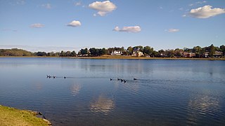
Lake Montebello is a reservoir located near Mayfield and Coldstream-Homestead-Montebello in Northeast Baltimore City in central Maryland. The lake was excavated and constructed in 1881, and nearby Montebello Filtration Plants 1 and 2 were completed in 1915 and 1928, respectively. The lake contains approximately 410 million US gallons (1,600,000 m3) of water, with a maximum storage of 606 million US gallons (2,290,000 m3). Today, the lake continues to act as a settling basin for what goes on in the filtration plant. A 1.3 mile bike and walking path lines the lake and are used as a recreational area for the surrounding community.


