
The Victoria Bridge is a vehicular and pedestrian bridge over the Brisbane River. The current bridge, opened in 1969, is the third permanent crossing erected at this location. Since 24 January 2021, the bridge was closed to general traffic and carried buses, pedestrians and cyclists only.

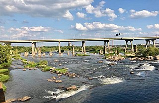
The James River is a river in the U.S. state of Virginia that begins in the Appalachian Mountains and flows 348 miles (560 km) to Chesapeake Bay. The river length extends to 444 miles (715 km) if one includes the Jackson River, the longer of its two source tributaries. It is the longest river in Virginia. Jamestown and Williamsburg, Virginia’s first colonial capitals, and Richmond, Virginia's current capital, lie on the James River.
The Chickahominy is an 87-mile-long (140 km) river in the eastern portion of the U.S. state of Virginia. The river, which serves as the eastern border of Charles City County, rises about 15 miles (24 km) northwest of Richmond and flows southeast and south to the James River. The river was named after the Chickahominy Indian tribe who lived near the river when it was claimed by English colonists in 1607. Chickahominy's descendants live in Charles City, Hanover, New Kent, and King William Counties today.

Manchester is a former independent city in Virginia in the United States. Prior to receiving independent status, it served as the county seat of Chesterfield County, between 1870 and 1876. Today, it is a part of the city of Richmond, Virginia.

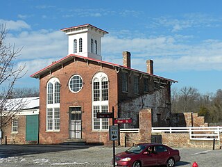
The Richmond and Danville Railroad (R&D) Company was a railroad that operated independently from 1847 until 1894, first in the U.S. state of Virginia and later on 3,300 miles (5,300 km) of track in nine states.
The Robert E. Lee Memorial Bridge in Richmond, Virginia carries U.S. Route 1 and U.S. Route 301 across the James River at the Fall Line.

The James River Bridge (JRB) is a four-lane divided highway lift bridge across the James River in the Commonwealth of Virginia. Owned and operated by the Virginia Department of Transportation, it carries U.S. Route 17 (US 17), US 258, and State Route 32 across the river near its mouth at Hampton Roads. The bridge connects Newport News on the Virginia Peninsula with Isle of Wight County in the South Hampton Roads region, and is the easternmost such crossing without a tunnel component.

Colonial Parkway is a 23-mile (37 km) scenic parkway linking the three points of Virginia's Historic Triangle, Jamestown, Williamsburg, and Yorktown. It is part of the National Park Service's Colonial National Historical Park. Virginia's official state classification for the parkway is State Route 90003. With portions built between 1930 and 1957, it links the three communities via a roadway shielded from views of commercial development. The roadway is toll-free, is free of semi trucks, and has speed limits of around 35 to 45 mph. As a National Scenic Byway and All-American Road, it is also popular with tourists due to the James River and York River ends of the parkway. A video drive-thru is available.
The Southside Railroad was formed in Virginia in 1846. Construction was begun in 1849 and completed in 1854. The 5 ft gauge railroad connected City Point, a port on the James River with the farm country south and west of Petersburg, Virginia, to Lynchburg, Virginia, a distance of about 132 miles (212 km).
Edward E. Willey Bridge is a highway bridge which crosses the upper James River in the western portion of Henrico County, Virginia. It carries Chippenham Parkway between Parham Road in Henrico and the southwestern portion of the independent city of Richmond. It was named in honor of Edward E. Willey who was a Pharmacist and State Senator in the Virginia General Assembly from 1952 to 1983. He died in 1986.

The Virginia State Capitol is the seat of state government of the Commonwealth of Virginia, located in Richmond, the third capital city of the U.S. state of Virginia. It houses the oldest elected legislative body in North America, the Virginia General Assembly, first established as the House of Burgesses in 1619.

The James River and Kanawha Canal was a partially built canal in Virginia intended to facilitate shipments of passengers and freight by water between the western counties of Virginia and the coast. Ultimately its towpath became the roadbed for a rail line following the same course.
Richmond Bridge is an 18th-century stone arch bridge that crosses the River Thames at Richmond, connecting the two halves of the present-day London Borough of Richmond upon Thames. It was designed by James Paine and Kenton Couse.
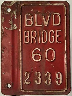
Boulevard Bridge in the independent city of Richmond, Virginia is a toll bridge which carries State Route 161 across the James River.
The Southside of Richmond is an area of the Metropolitan Statistical Area surrounding Richmond, Virginia. It generally includes all portions of the City of Richmond which lie south of the James River, and includes all of the former city of Manchester. Depending on context, the term "Southside of Richmond" can include some northern areas of adjacent Chesterfield County, Virginia in the Richmond-Petersburg region. With minor exceptions near Bon Air, VA, the Chippenham Parkway forms the border between Chesterfield County and the City of Richmond portions of Southside, with some news agencies using the term "South Richmond" to refer to the locations in Southside located in the city proper.
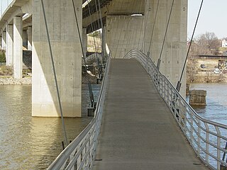
Huguenot Memorial Bridge is located in Henrico County and the independent city of Richmond, Virginia. It carries State Route 147 across the former Chesapeake and Ohio Railway, the James River and Kanawha Canal, and the James River in the Fall Line region above the head of navigation at Richmond.
Manchester Bridge in Richmond, Virginia carries U.S. Route 60 across the James River.

Shockoe Bottom is an area in Richmond, Virginia, just east of downtown, along the James River. Located between Shockoe Hill and Church Hill, Shockoe Bottom contains much of the land included in Colonel William Mayo's 1737 plan of Richmond, making it one of the city's oldest neighborhoods.

The James River Bridge carries Interstate 95 across the James River in Richmond, Virginia.
Shockoe Valley is an area in Richmond, Virginia, just east of downtown, along the James River, and is the entertainment center of the city. Located between Shockoe Hill and Church Hill, Shockoe Valley contains much of the land included in Colonel William Mayo's 1737 plan of Richmond, making it one of the city's oldest neighborhoods. Shockoe Valley encompasses the smaller neighborhoods of Shockoe Slip, Shockoe Bottom and Tobacco Row along Cary Street.


