The United States Armed Forces are the military forces of the United States of America. It consists of the Army, Marine Corps, Navy, Air Force, and Coast Guard. The President of the United States is the Commander-in-Chief of the Armed Forces and forms military policy with the Department of Defense (DoD) and Department of Homeland Security (DHS), both federal executive departments, acting as the principal organs by which military policy is carried out. All five armed services are among the seven uniformed services of the United States.

The United States Attorney General (A.G.) is the chief lawyer of the federal government of the United States, head of the United States Department of Justice per 28 U.S.C. § 503, and oversees all governmental legal affairs.

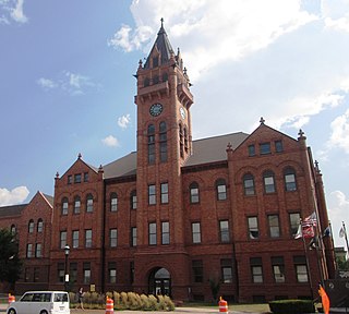
Lafayette County is a county located in the western portion of the U.S. state of Missouri. As of the 2010 census, the population was 33,381. Its county seat is Lexington. The county was organized November 16, 1820 from Cooper County and originally named Lillard County for James Lillard of Tennessee, who served in the first state constitutional convention and first state legislature. It was renamed Lafayette County on February 16, 1825, in honor of Revolutionary War hero the Marquis de La Fayette, who was then visiting the United States.

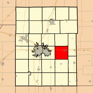
Mayview is a city in Lafayette County, Missouri, United States. The population was 211 at the 2010 census.

Blowing Rock is a town in Watauga and Caldwell counties in the U.S. state of North Carolina. The population was 1,241 at the 2010 census.

The Federal Government of the United States is the national government of the United States, a federal republic in North America, composed of 50 states, a federal district, five major self-governing territories, and several island possessions. The federal government is composed of three distinct branches: legislative, executive, and judicial, whose powers are vested by the U.S. Constitution in the Congress, the President, and the federal courts, respectively. The powers and duties of these branches are further defined by acts of congress, including the creation of executive departments and courts inferior to the Supreme Court.

Personnel Armor System for Ground Troops is a combat helmet and ballistic vest that was used by the United States military from the early 1980s until the mid-2000s, when the helmet and vest were succeeded by the Lightweight Helmet (LWH), Modular Integrated Communications Helmet (MICH), and Interceptor Body Armor (IBA) respectively.
Saint Joseph Township is a township in Champaign County, Illinois, USA. As of the 2010 census, its population was 5,876 and it contained 2,252 housing units.
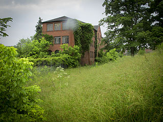
Mayview State Hospital is a former psychiatric hospital, originally known as Marshalsea Poor Farm, located in South Fayette Township near Bridgeville, Pennsylvania. It spanned 335 acres (136 ha) and had 39 buildings, 12 of which were used for patient care and hospital administration. It had a staff count of approximately 502 as of August 2007, and an operating budget of $63 million per year.

The West Raleigh Historic District in Raleigh, North Carolina is a national historic district listed on the National Register of Historic Places in 2003. Located 1.5 miles (2.41 km) west-northwest of the State Capitol, the district encompasses approximately 332 acres (134 ha). Neighborhoods in the district include: Bedford Heights, Bagwell, Blue Moon Ridge, College Crest, Fairmont, Forest Hills, Harris-Chamberlain, and Wilmont. Most homes in these neighborhoods are one-story and were constructed between the 1930s to 1950s. While the district is mostly residential, churches and commercial buildings are common along Hillsborough Street.

In the United States, a state is a constituent political entity, of which there are currently 50. Bound together in a political union, each state holds governmental jurisdiction over a separate and defined geographic territory and shares its sovereignty with the federal government. Due to this shared sovereignty, Americans are citizens both of the federal republic and of the state in which they reside. State citizenship and residency are flexible, and no government approval is required to move between states, except for persons restricted by certain types of court orders. Four states use the term commonwealth rather than state in their full official names.

The United States dollar is the official currency of the United States and its territories per the United States Constitution since 1792. In practice, the dollar is divided into 100 smaller cent (¢) units, but is occasionally divided into 1000 mills (₥) for accounting. The circulating paper money consists of Federal Reserve Notes that are denominated in United States dollars.
Travis Hocutt "Tommy" Tomlinson was mayor of Raleigh, North Carolina from 1965 to 1969.

Triticum compactum erinaceum, also called California Club Wheat or Mayview wheat, is an extinct subspecies of the hexaploid club wheat Triticum compactum. T. compactum erinaceum was a bearded, hairy rachis, red-chaffed wheat named for its appearance similar to that of a hedgehog. T. compactum erinaceum was thought to have disappeared before 1822. However data from the United States Department of Agriculture indicates two additional specimen that were discovered and identified as T. compactum erinaceum more than a hundred years after their presumed disappearance. The new specimen indicate that T. compactum erinaceum was grown in the United States until the dust bowl era, at which point it presumably disappeared. There have only been four recorded specimens of T. compactum erinaceum.
Mayview is an unincorporated community in Garfield County, in the U.S. state of Washington.