McGregor, Florida

Last updated

McGregor, Florida
Lee County Florida Incorporated and Unincorporated areas McGregor Highlighted.svg
Location in Lee County and the state of Florida
Coordinates: 26°33′49″N81°54′35″W / 26.56361°N 81.90972°W / 26.56361; -81.90972
CountryUnited States
State Flag of Florida.svg  Florida
County Lee
Area
[1]
  Total4.07 sq mi (10.54 km2)
  Land2.37 sq mi (6.13 km2)
  Water1.70 sq mi (4.41 km2)
Elevation
7 ft (2 m)
Population
 (2020)
  Total7,976
  Density3,371.09/sq mi (1,301.74/km2)
Time zone UTC-5 (Eastern (EST))
  Summer (DST) UTC-4 (EDT)
ZIP code
33919 [2]
Area code 239
FIPS code 12-42090 [3]
GNIS feature ID1867172 [4]

McGregor is a census-designated place (CDP) in Lee County, Florida, United States. The population was 7,976 at the 2020 census [5] , up from 7,406 at the 2010 census. It is part of the Cape Coral-Fort Myers, Florida Metropolitan Statistical Area.

Contents

A strong EF2 tornado struck the town on January 16, 2022, causing major damage.

Geography

McGregor is located in central Lee County at 26°33′49″N81°54′35″W / 26.56361°N 81.90972°W / 26.56361; -81.90972 (26.563603, -81.909692), [6] in an unincorporated part of the county. It is bordered to the east by Whiskey Creek, to the southeast by Cypress Lake, and to the southwest by Iona, all unincorporated. McGregor is bordered to the northwest by the tidal Caloosahatchee River, across which is the city of Cape Coral. The Cape Coral Bridge crosses the Caloosahatchee River from McGregor.

Florida State Road 867 (McGregor Boulevard) is the main road through the community. It leads northeast 6 miles (10 km) to the center of Fort Myers, the Lee county seat, and southwest 4 miles (6 km) to San Carlos Boulevard in Iona.

According to the United States Census Bureau, the McGregor CDP has a total area of 4.1 square miles (10.5 km2), of which 2.4 square miles (6.1 km2) are land and 1.7 square miles (4.4 km2), or 41.86%, are water. [7]

Demographics

Historical population
CensusPop.Note
1990 6,504
2000 7,1369.7%
2010 7,4063.8%
2020 7,9767.7%
sources: [8] [9]

As of the census [3] of 2000, there were 7,136 people, 3,295 households, and 2,296 families residing in the CDP. The population density was 2,784.1 inhabitants per square mile (1,074.9/km2). There were 3,982 housing units at an average density of 1,553.6 per square mile (599.8/km2). The racial makeup of the CDP was 96.09% White, 0.84% African American, 0.20% Native American, 1.56% Asian, 0.39% from other races, and 0.92% from two or more races. Hispanic or Latino of any race were 2.91% of the population.

There were 3,295 households, out of which 17.8% had children under the age of 18 living with them, 62.0% were married couples living together, 5.7% had a female householder with no husband present, and 30.3% were non-families. 25.0% of all households were made up of individuals, and 13.7% had someone living alone who was 65 years of age or older. The average household size was 2.17 and the average family size was 2.55.

In the CDP, the population was spread out, with 15.0% under the age of 18, 3.3% from 18 to 24, 19.2% from 25 to 44, 31.9% from 45 to 64, and 30.6% who were 65 years of age or older. The median age was 53 years. For every 100 females, there were 92.3 males. For every 100 females age 18 and over, there were 89.8 males.

The median income for a household in the CDP was $57,628, and the median income for a family was $67,353. Males had a median income of $52,151 versus $31,732 for females. The per capita income for the CDP was $45,240. About 1.3% of families and 3.3% of the population were below the poverty line, including 2.7% of those under age 18 and 2.6% of those age 65 or over.

Related Research Articles

<span class="mw-page-title-main">Alva, Florida</span> Census-designated place in Florida, United States

Alva is an unincorporated community and census-designated place (CDP) in Lee County, Florida, United States, situated on the Caloosahatchee River. The population was 2,725 at the 2020 census, up from 2,596 at the 2010 census. It is part of the Cape Coral-Fort Myers, Florida Metropolitan Statistical Area.

<span class="mw-page-title-main">Buckingham, Florida</span> Census-designated place in Florida, United States

Buckingham is an unincorporated community and census-designated place (CDP) in Lee County, Florida, United States. The population was 4,443 at the 2020 census, up from 4,036 at the 2010 census. It is part of the Cape Coral-Fort Myers, Florida Metropolitan Statistical Area.

<span class="mw-page-title-main">Cypress Lake, Florida</span> Census-designated place in Florida, United States

Cypress Lake is an unincorporated community and census-designated place (CDP) in Lee County, Florida, United States. The population was 13,727 at the 2020 census. It is part of the Cape Coral-Fort Myers, Florida Metropolitan Statistical Area.

<span class="mw-page-title-main">East Dunbar, Fort Myers, Florida</span> Neighborhood in Lee, Florida, United States

East Dunbar is a former census-designated place (CDP) in Lee County, Florida, United States. The population was 1,935 at the 2000 census. The area has been annexed by the city of Fort Myers and is part of the Cape Coral-Fort Myers, Florida Metropolitan Statistical Area.

<span class="mw-page-title-main">Fort Myers Shores, Florida</span> Census-designated place in Florida, United States

Fort Myers Shores is an unincorporated community and census-designated place (CDP) in Lee County, Florida, United States. The population was 5,774 at the 2020 census, up from 5,487 at the 2010 census. It is part of the Cape Coral-Fort Myers, Florida Metropolitan Statistical Area.

<span class="mw-page-title-main">Harlem Heights, Florida</span> Census-designated place in Florida, United States

Harlem Heights is an unincorporated community and census-designated place (CDP) in Lee County, Florida, United States. The population was 1,930 at the 2020 census, down from 1,975 at the 2010 census. It is part of the Cape Coral-Fort Myers, Florida Metropolitan Statistical Area.

<span class="mw-page-title-main">Iona, Florida</span> Census-designated place in Florida, United States

Iona is an unincorporated community and census-designated place (CDP) in Lee County, Florida, United States. The population was 16,908 at the 2020 census, up from 15,404 at the 2010 census. It is part of the Cape Coral-Fort Myers, Florida Metropolitan Statistical Area.

<span class="mw-page-title-main">Lochmoor Waterway Estates, Florida</span> Census-designated place in Florida, United States

Lochmoor Waterway Estates is an unincorporated community and census-designated place (CDP) in Lee County, Florida, United States. The population was 5,828 at the 2020 census, up from 4,204 at the 2010 census. It is part of the Cape Coral-Fort Myers, Florida Metropolitan Statistical Area.

<span class="mw-page-title-main">Matlacha, Florida</span> Census-designated place in Florida, United States

Matlacha is a census-designated place (CDP) in Lee County, Florida, United States. The CDP had a population of 598 at the 2020 census, down from 677 at the 2010 census. It is part of the Cape Coral-Fort Myers, Florida Metropolitan Statistical Area.

<span class="mw-page-title-main">North Fort Myers, Florida</span> Census-designated place in Florida, United States

North Fort Myers is an unincorporated area and census-designated place (CDP) in Lee County, Florida, United States. The population was 42,719 at the 2020 census, up from 39,407 at the 2010 census. It is part of the Cape Coral-Fort Myers, Florida Metropolitan Statistical Area.

<span class="mw-page-title-main">Olga, Florida</span> Census-designated place in Florida, United States

Olga is an unincorporated community and census-designated place (CDP) in Lee County, Florida, United States. The population was 2,270 at the 2020 census, up from 1,952 at the 2010 census. It is part of the Cape Coral-Fort Myers, Florida Metropolitan Statistical Area.

<span class="mw-page-title-main">Palmona Park, Florida</span> Census-designated place in Florida, United States

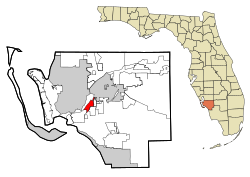
Palmona Park is a census-designated place (CDP) in Lee County, Florida, United States. The population was 1,240 at the 2020 census, down from 1,146 at the 2010 census. It is part of the Cape Coral-Fort Myers, Florida Metropolitan Statistical Area.

<span class="mw-page-title-main">San Carlos Park, Florida</span> Census-designated place in Florida, United States

San Carlos Park is a census-designated place (CDP) in Lee County, Florida, United States. The population was 18,563 at the 2020 census, up from 16,824 at the 2010 census. It is part of the Cape Coral-Fort Myers, Florida Metropolitan Statistical Area.

<span class="mw-page-title-main">St. James City, Florida</span> Census-designated place in Florida, United States

St. James City is an unincorporated community and census-designated place (CDP) on Pine Island in Lee County, Florida, United States. The population was 3,876 at the 2020 census, up from 3,784 at the 2010 census. It is part of the Cape Coral-Fort Myers, Florida Metropolitan Statistical Area.

<span class="mw-page-title-main">Suncoast Estates, Florida</span> Census-designated place in Florida, United States

Suncoast Estates is a census-designated place (CDP) in Lee County, Florida, United States. The population was 4,097 at the 2020 census, down from 4,384 at the 2010 census. It is part of the Cape Coral-Fort Myers, Florida Metropolitan Statistical Area.

<span class="mw-page-title-main">Three Oaks, Florida</span> Census-designated place in Florida, United States

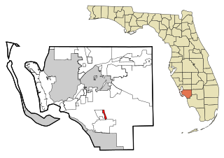
Three Oaks is a census-designated place (CDP) in Lee County, Florida, United States. The population was 5,472 at the 2020 census, up from 3,592 at the 2010 census. It is part of the Cape Coral-Fort Myers, Florida Metropolitan Statistical Area.

<span class="mw-page-title-main">Tice, Florida</span> Census-designated place in Florida, United States

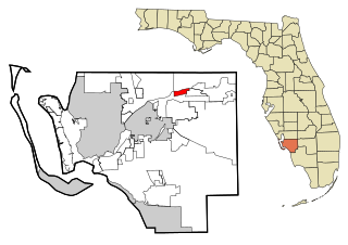
Tice is an unincorporated community and census-designated place (CDP) in Lee County, Florida, United States. As of the 2020 census, the CDP population was 4,853. It is part of the Cape Coral-Fort Myers, Florida Metropolitan Statistical Area.

<span class="mw-page-title-main">Villas, Florida</span> Census-designated place in Florida, United States

Villas, Florida is an unincorporated community and census-designated place (CDP) in Lee County, Florida, United States. The population was 12,687 at the 2020 census, up from 11,569 at the 2010 census. It is part of the Cape Coral-Fort Myers, Florida Metropolitan Statistical Area.

<span class="mw-page-title-main">Whiskey Creek, Florida</span> Census-designated place in Florida, United States

Whiskey Creek is a census-designated place (CDP) in Lee County, Florida, United States. The population was 4,842 at the 2020 census, up from 4,655 at the 2010 census. It is part of the Cape Coral-Fort Myers, Florida Metropolitan Statistical Area.

<span class="mw-page-title-main">Coral Terrace, Florida</span> Census-designated place in Florida

Coral Terrace is a suburban unincorporated community and census-designated place (CDP) in Miami-Dade County, Florida, United States. It is part of the Miami metropolitan area of South Florida. The population was 23,142 at the 2020 census, down from 24,376 in 2010.

References

  1. "2020 U.S. Gazetteer Files". United States Census Bureau. Retrieved October 31, 2021.
  2. "McGregor FL ZIP Code". zipdatamaps.com. 2023. Retrieved January 26, 2023.
  3. 1 2 "U.S. Census website". United States Census Bureau. Retrieved January 31, 2008.
  4. "US Board on Geographic Names". United States Geological Survey. October 25, 2007. Retrieved January 31, 2008.
  5. "Explore Census Data". data.census.gov. Retrieved September 30, 2022.
  6. "US Gazetteer files: 2010, 2000, and 1990". United States Census Bureau. February 12, 2011. Retrieved April 23, 2011.
  7. "U.S. Gazetteer Files: 2019: Places: Florida". U.S. Census Bureau Geography Division. Retrieved November 25, 2019.
  8. "CENSUS OF POPULATION AND HOUSING (1790-2000)". U.S. Census Bureau. Retrieved July 17, 2010.
  9. "Profile of General Population and Housing Characteristics: 2010 Census Summary File 1 (DP-1), McGregor CDP, Florida". American FactFinder. U.S. Census Bureau. Archived from the original on February 13, 2020. Retrieved November 25, 2019.