Medina, North Dakota

Last updated

Medina, North Dakota
Medina, North Dakota 6-10-2008.jpg
Business District of Medina
ND Stutsman County Medina.svg
Location of Medina, North Dakota
Coordinates: 46°53′38″N99°18′00″W / 46.89389°N 99.30000°W / 46.89389; -99.30000
CountryUnited States
State North Dakota
County Stutsman
Area
[1]
  Total1.21 sq mi (3.14 km2)
  Land1.21 sq mi (3.14 km2)
  Water0.00 sq mi (0.00 km2)
Elevation
[2]
1,808 ft (551 m)
Population
 (2020)
  Total264
  Density217.46/sq mi (83.95/km2)
Time zone UTC-6 (CST)
  Summer (DST) UTC-5 (CDT)
ZIP code
58467
Area code 701
FIPS code 38-51860
GNIS feature ID1036157 [2]
Website medinand.com

Medina is a town in Stutsman County, North Dakota, United States. The population was 264 at the 2020 census. [3] Medina was founded in 1899.

Contents

Geography

According to the United States Census Bureau, the town has a total area of 1.02 square miles (2.64 km2), all land. [4]

History

Medina was originally called Eleventh Siding, and under the latter name got its start in the 1870s when the railroad was extended to that point. [5] A post office called Medina has been in operation since 1888. [6] The city took its name after Medina, New York. [7]

The town made national news on February 13, 1983 when it was the site of a shoot-out in which two U.S. Marshals were slain.

Demographics

Historical population
CensusPop.Note
1910 343
1920 41521.0%
1930 407−1.9%
1940 50022.9%
1950 56412.8%
1960 545−3.4%
1970 488−10.5%
1980 5216.8%
1990 387−25.7%
2000 335−13.4%
2010 308−8.1%
2020 264−14.3%
2021 (est.)270 [8] 2.3%
U.S. Decennial Census [9]
2020 Census [3]

2010 census

As of the census [10] of 2010, there were 308 people, 144 households, and 82 families residing in the town. The population density was 302.0 inhabitants per square mile (116.6/km2). There were 182 housing units at an average density of 178.4 per square mile (68.9/km2). The racial makeup of the city was 96.4% White, 0.3% Asian, and 3.2% from two or more races. Hispanic or Latino of any race were 0.6% of the population.

There were 144 households, of which 26.4% had children under the age of 18 living with them, 45.1% were married couples living together, 6.9% had a female householder with no husband present, 4.9% had a male householder with no wife present, and 43.1% were non-families. 37.5% of all households were made up of individuals, and 16.7% had someone living alone who was 65 years of age or older. The average household size was 2.14 and the average family size was 2.82.

The median age in the town was 43.3 years. 25.6% of residents were under the age of 18; 5.7% were between the ages of 18 and 24; 19.8% were from 25 to 44; 26% were from 45 to 64; and 22.7% were 65 years of age or older. The gender makeup of the city was 44.5% male and 55.5% female.

2000 census

As of the census of 2000, there were 335 people, 165 households, and 99 families residing in the city. The population density was 331.3 inhabitants per square mile (127.9/km2). There were 209 housing units at an average density of 206.7 per square mile (79.8/km2). The racial makeup of the city was 99.40% White, and 0.60% from two or more races. Hispanic or Latino of any race were 0.30% of the population.

There were 165 households, out of which 19.4% had children under the age of 18 living with them, 52.1% were married couples living together, 3.6% had a female householder with no husband present, and 39.4% were non-families. 37.6% of all households were made up of individuals, and 26.1% had someone living alone who was 65 years of age or older. The average household size was 2.03 and the average family size was 2.62.

In the town, the population was spread out, with 20.0% under the age of 18, 2.1% from 18 to 24, 20.6% from 25 to 44, 23.6% from 45 to 64, and 33.7% who were 65 years of age or older. The median age was 50 years. For every 100 females, there were 79.1 males. For every 100 females age 18 and over, there were 78.7 males.

The median income for a household in the town was $22,059, and the median income for a family was $31,500. Males had a median income of $31,458 versus $17,500 for females. The per capita income for the town was $16,860. About 4.8% of families and 14.1% of the population were below the poverty line, including 15.4% of those under age 18 and 15.0% of those age 65 or over.

Climate

This climatic region is typified by large seasonal temperature differences, with warm to hot (and often humid) summers and cold (sometimes severely cold) winters. According to the Köppen Climate Classification system, Elm Creek has a humid continental climate, abbreviated "Dfb" on climate maps. [11]

Related Research Articles

<span class="mw-page-title-main">Hettinger, North Dakota</span> City in North Dakota, United States

Hettinger is a city in, and the county seat of, Adams County, North Dakota, United States. The population was 1,074 at the 2020 census.

<span class="mw-page-title-main">Warwick, North Dakota</span> City in North Dakota, United States

Warwick is a city in Benson County, North Dakota, United States. The population was 55 at the 2020 census. Warwick was founded in 1907.

<span class="mw-page-title-main">Willow City, North Dakota</span> City in North Dakota, United States

Willow City is a city in Bottineau County, North Dakota, United States. The population was 149 at the 2020 census. Willow City was founded in 1887.

<span class="mw-page-title-main">Scranton, North Dakota</span> City in North Dakota, United States

Scranton is a small town in Bowman County, North Dakota, United States. The population was 258 at the 2020 census.

<span class="mw-page-title-main">Lincoln, North Dakota</span> City in North Dakota, United States

Lincoln is a city in Burleigh County, North Dakota, United States. It is a suburb of adjacent Bismarck, and also a core city of the Bismarck-Mandan Metropolitan Statistical Area. The population was 4,257 at the 2020 census, making it the fourteenth largest city in North Dakota. Lincoln was founded in 1977.

<span class="mw-page-title-main">Wishek, North Dakota</span> City in North Dakota, United States

Wishek is a city in McIntosh County, North Dakota, United States. The population was 864 at the 2020 census.

<span class="mw-page-title-main">Buchanan, North Dakota</span> City in North Dakota, United States

Buchanan is a city in Stutsman County, North Dakota, United States. The population was 87 at the 2020 census. Buchanan was founded in 1887.

<span class="mw-page-title-main">Cleveland, North Dakota</span> City in North Dakota, United States

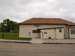
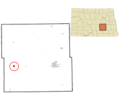
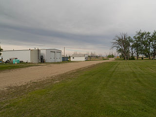
Cleveland is a city in Stutsman County, North Dakota, United States. The population was 57 at the 2020 census.

<span class="mw-page-title-main">Courtenay, North Dakota</span> City in North Dakota, United States

Courtenay is a city in Stutsman County, North Dakota, United States. The population was 36 at the 2020 census. Courtenay was founded in 1893.

<span class="mw-page-title-main">Kensal, North Dakota</span> City in North Dakota, United States

Kensal is a city in Stutsman County, North Dakota, United States. The population was 146 at the 2020 census. Kensal was founded in 1892.

<span class="mw-page-title-main">Montpelier, North Dakota</span> City in North Dakota, United States

Montpelier is a city in Stutsman County, North Dakota, United States. The population was 85 at the 2020 census. Montpelier was founded in 1885.

<span class="mw-page-title-main">Pingree, North Dakota</span> City in North Dakota, United States

Pingree is a city in Stutsman County, North Dakota, United States. The population was 41 at the 2020 census. Pingree was founded in 1882.

<span class="mw-page-title-main">Woodworth, North Dakota</span> City in North Dakota, United States

Woodworth is a city in Stutsman County, North Dakota, United States. The population was 44 at the 2020 census.

<span class="mw-page-title-main">Park River, North Dakota</span> City in North Dakota, United States

Park River is a city in Walsh County, North Dakota, United States. The population was 1,424 at the 2020 census. Park River was founded in 1884.

<span class="mw-page-title-main">Kenmare, North Dakota</span> City in North Dakota, United States

Kenmare is a city in Ward County, North Dakota, United States. The population was 961 at the 2020 census. Kenmare is part of the Minot Micropolitan Statistical Area.

<span class="mw-page-title-main">Pukwana, South Dakota</span> Town in South Dakota, United States

Pukwana is a town in Brule County, South Dakota, United States. The population was 233 at the 2020 census.

<span class="mw-page-title-main">Wagner, South Dakota</span> City in South Dakota, United States

Wagner is a city in Charles Mix County, South Dakota, United States. The population was 1,490 at the 2020 census. The city is served by Wagner Municipal Airport as well as YST Transit buses.

<span class="mw-page-title-main">Parkston, South Dakota</span> City in South Dakota, United States

Parkston is a city in Hutchinson County, South Dakota, United States. The population was 1,567 at the 2020 census.

<span class="mw-page-title-main">Cottonwood, South Dakota</span> Town in the United States

Cottonwood is a small rural hamlet in Jackson County, South Dakota, United States. The population was 12 at the 2020 census. There are no businesses or services at Cottonwood.

<span class="mw-page-title-main">Wasta, South Dakota</span> Town in South Dakota, United States

Wasta(Lakota: wašté) is a town in Pennington County, South Dakota, United States, situated along the Cheyenne River. It had a population of 65 at the 2020 census.

References

  1. "ArcGIS REST Services Directory". United States Census Bureau. Retrieved September 20, 2022.
  2. 1 2 U.S. Geological Survey Geographic Names Information System: Medina, North Dakota
  3. 1 2 "2020 Census Redistricting Data (Public Law 94-171) Summary File". American FactFinder. United States Census Bureau . Retrieved April 22, 2022.
  4. "US Gazetteer files 2010". United States Census Bureau. Archived from the original on January 12, 2012. Retrieved June 14, 2012.
  5. Olstad, Geneva Roth (2000). Main Street, North Dakota in Vintage Postcards. Arcadia Publishing. p. 67. ISBN   978-0-7385-0726-2.
  6. "Stutsman County". Jim Forte Postal History. Retrieved October 22, 2015.
  7. Federal Writers' Project (1938). North Dakota, a Guide to the Northern Prairie State. WPA. p. 285. ISBN   978-1-62376-033-5.
  8. "City and Town Population Totals: 2020-2021". United States Census Bureau. May 29, 2022. Retrieved May 30, 2022.
  9. United States Census Bureau. "Census of Population and Housing" . Retrieved October 31, 2013.
  10. "U.S. Census website". United States Census Bureau . Retrieved June 14, 2012.
  11. Climate Summary for Medina, North Dakota