
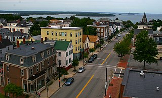
Portland is a city in the U.S. state of Maine. It is the most populous city in the state and the seat of Cumberland County. Portland's population was 68,408 in April 2020. The Greater Portland metropolitan area has a population of approximately 550,000 people. Historically tied to commercial shipping, the marine economy, and light industry, Portland's economy in the 21st century relies mostly on the service sector. The Port of Portland is the second-largest tonnage seaport in the New England area as of 2019.

Westbrook is a city in Cumberland County, Maine, United States and a suburb of Portland. The population was 20,400 at the 2020 census, making it the fastest-growing city in Maine between 2010 and 2020. It is part of the Portland–South Portland–Biddeford, Maine metropolitan statistical area.

The Fore River is a short horn-shaped estuary, approximately 5.7 miles (9.2 km) long, separating Portland and South Portland in Maine in the United States. Many of the port facilities of the Portland harbor are along the estuary, which is formed just southwest of Portland by the confluence of several creeks. The estuary was initially known as Levett's River, so named by the first English settler of the Casco Bay region, Capt. Christopher Levett. But shortly afterwards, the estuary came to have the name by which it is known today.
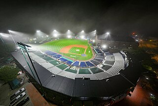
Hadlock Field is a minor league baseball stadium in Portland, Maine. It is primarily home to the Portland Sea Dogs of the Eastern League but also the Portland High School Bulldogs and Deering High School Rams baseball teams. The stadium is named for Edson B. Hadlock Jr., a long-time Portland High School baseball coach and physics teacher and member of the Maine Baseball Hall of Fame.

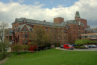
Portland High School is a public high school established in 1821 in Portland, Maine, United States, which educates grades 9–12. The school is part of the Portland Public Schools district, and is one of three high schools in that district, along with Deering High School and Casco Bay High School. It is located at 284 Cumberland Avenue in downtown Portland. Along with its sister school, Deering High School, a family can choose which of the two to send their students to.
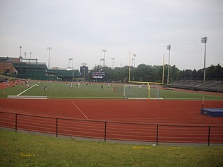
James J. Fitzpatrick Stadium is a 6,000 seat multi-purpose outdoor stadium in Portland, Maine, United States. It is located between Interstate 295, Hadlock Field baseball stadium, King Middle School, and the Portland Exposition Building. It is located across the street from Deering Oaks. Formerly known as Portland Stadium, it was renamed in 1989 to honor James J. Fitzpatrick, one of the most respected figures in Maine athletic history.
Munjoy Hill is both a neighborhood and prominent geographical feature of Portland, Maine. It is located east of downtown and south of East Deering, the neighborhood it is connected to by Tukey's Bridge. The neighborhood historically had a large Irish and Italian American population.
The Stroudwater River is a 15.2-mile-long (24.5 km) river located mostly in Cumberland County, Maine. The river begins as a small stream at Duck Pond in Buxton and grows as it flows through Buxton, Gorham, Westbrook, and finally Portland before emptying into the Fore River at Stroudwater falls in Portland's Stroudwater neighborhood. Several smaller streams flow into the river in Buxton and Gorham, including Deering Brook, Gully Brook, Fogg Brook and Silver Brook.

The Ballpark is a baseball stadium in Old Orchard Beach, Maine, United States. The venue has a seating capacity of 6,000 and is a former Triple-A baseball facility that was almost destroyed by years of neglect until a community organized volunteer effort revived the stadium.

Deering Center is a neighborhood in the residential area of Portland, Maine, United States.
The Ellis River is a 23-mile-long (37 km) river in Oxford County in western Maine. It is a tributary of the Androscoggin River.
The West End is a downtown neighborhood in Portland, Maine. It is located on the western side of Portland's peninsula primarily on Bramhall Hill and is noted for its architecture and history. The neighborhood is home to many late 19th- and early 20th-century homes and, in 2010, it was called "one of the best preserved Victorian neighborhoods in the country". The Western Promenade, a park laid out in 1836, overlooks the forests and small settlements of Southwestern Maine, along with the distant White Mountains. Other historic structures include 68 High Street, The Gothic House, Brown House, Butler House, Ingraham House, Morrill Mansion and the Minott House.

GPS Portland Phoenix was an American soccer team based in Portland, Maine. Founded in 2009, the team played in USL League Two, the fourth tier of the American Soccer Pyramid, in the Northeast Division of the Eastern Conference. It has not played since 2019.

The Maine Rebels are a football team in the Independent Women's Football League based in Portland, Maine. Home games are played at Memorial Stadium on the campus of Deering High School. They were formerly known as the Southern Maine Rebels until 2011.
The Portland Farmers Market is a farmers market in Portland, Maine, U.S., which has been in continuous operation since 1768. Since 1990, the market has been held place year-round. From May to November, it is held on Wednesdays in Monument Square and on Saturdays in Deering Oaks Park. From December to April, the winter market is held on Saturdays in the former Catherine McAuley High School building.
The Arts District is a section of downtown Portland, Maine’s designated in 1995 as to promote the cultural community and creative economy of the city. It covers a large part of upper Congress Street towards the West End and spans Congress Street toward the East ending at Portland City Hall and its Merrill Auditorium concert hall.

The South Portland A-26 Invader crash was the worst aviation accident in Maine history. It occurred in the historic Brick Hill neighborhood of South Portland.
Portland, Maine, is home to many neighborhoods.
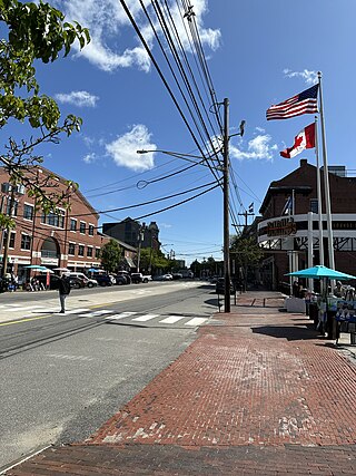
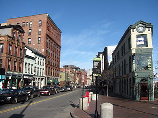
Commercial Street is a downtown street in the Old Port of Portland, Maine, United States. It is part of U.S. Route 1A. It became the Old Port's waterfront in the early 20th century, replacing Fore Street, after land was reclaimed from the waters of Casco Bay and the Fore River.

Cumberland Avenue is a downtown street in Portland, Maine, United States. It runs for around 1.57 miles (2.53 km) from Merrill Street, on Munjoy Hill in the northeast, to Deering Avenue in the southwest.

