Menomonie (town), Wisconsin

Last updated

Menomonie, Wisconsin
WIMap-doton-Menomonie.png
Location of Menomonie, Wisconsin
Coordinates: 44°52′53″N91°57′38″W / 44.88139°N 91.96056°W / 44.88139; -91.96056
Country Flag of the United States.svg  United States
State Flag of Wisconsin.svg  Wisconsin
County Dunn
Area
  Total42.0 sq mi (108.8 km2)
  Land41.8 sq mi (108.3 km2)
  Water0.2 sq mi (0.5 km2)
Elevation
[1]
860 ft (262 m)
Population
 (2000)
  Total3,174
  Density75.9/sq mi (29.3/km2)
Time zone UTC-6 (Central (CST))
  Summer (DST) UTC-5 (CDT)
Area code(s) 715 & 534
FIPS code 55-51050 [2]
GNIS feature ID1583697 [1]
Website http://www.townofmenomonie.com

Menomonie is a town in Dunn County, Wisconsin, United States. The population was 3,174 at the 2000 census. The unincorporated community of Irvington lies within the town, as does most of the City of Menomonie.

Contents

Geography

According to the United States Census Bureau, the town has a total area of 42.0 square miles (108.8 km2), of which, 41.8 square miles (108.3 km2) of it is land and 0.2 square miles (0.5 km2) of it (0.50%) is water.

Demographics

Historical population
CensusPop.Note
1990 2,732
2000 3,17416.2%
2010 3,3666.0%
2020 (est.)3,5034.1%

As of the census [2] of 2000, there were 3,174 people, 1,129 households, and 871 families residing in the town. The population density was 75.9 people per square mile (29.3/km2). There were 1,166 housing units at an average density of 27.9 per square mile (10.8/km2). The racial makeup of the town was 92.25% White, 0.09% Black or African American, 0.13% Native American, 6.81% Asian, 0.19% from other races, and 0.54% from two or more races. 0.54% of the population were Hispanic or Latino of any race.

There were 1,129 households, out of which 37.5% had children under the age of 18 living with them, 67.1% were married couples living together, 6.6% had a female householder with no husband present, and 22.8% were non-families. 17.1% of all households were made up of individuals, and 5.8% had someone living alone who was 65 years of age or older. The average household size was 2.81 and the average family size was 3.18.

In the town, the population was spread out, with 30.5% under the age of 18, 6.7% from 18 to 24, 27.8% from 25 to 44, 25.9% from 45 to 64, and 9.1% who were 65 years of age or older. The median age was 36 years. For every 100 females, there were 99.2 males. For every 100 females age 18 and over, there were 101.6 males.

The median income for a household in the town was $43,547, and the median income for a family was $52,931. Males had a median income of $35,240 versus $23,950 for females. The per capita income for the town was $20,814. About 4.7% of families and 8.1% of the population were below the poverty line, including 16.1% of those under age 18 and 5.4% of those age 65 or over.

Related Research Articles

<span class="mw-page-title-main">Garrett, Illinois</span> Village in Illinois, United States

Garrett is a village in Douglas County, Illinois, United States. The population was 122 at the 2020 census.

<span class="mw-page-title-main">Culver, Indiana</span> Town in Indiana, United States

Culver is a town in Marshall County, Indiana, United States. Culver is part of Union Township, which also includes the communities of Burr Oak, Hibbard, Maxinkuckee and Rutland. The population of Culver was 1,129 at the 2020 United States Census.

<span class="mw-page-title-main">Morocco, Indiana</span> Town in Indiana, United States

Morocco is a town in Beaver Township, Newton County, in the U.S. state of Indiana. The population was 1,129 at the 2010 census.

<span class="mw-page-title-main">Glenview Hills, Kentucky</span> City in Kentucky, United States

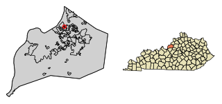
Glenview Hills is a home rule-class city in Jefferson County, Kentucky, United States. The population was 319 at the 2010 census.

<span class="mw-page-title-main">Sunset, Louisiana</span> Town in Louisiana, United States

Sunset is a town in St. Landry Parish, Louisiana, United States. The population was 2,897 at the 2010 census, up from 2,352 in 2000. It is part of the Opelousas–Eunice Micropolitan Statistical Area.

<span class="mw-page-title-main">Perham, Maine</span> Town in the state of Maine, United States

Perham is a town in Aroostook County, Maine, United States. The population was 371 at the 2020 census. The town was named after Maine's 33rd governor, Sidney Perham.

<span class="mw-page-title-main">Wayne, Maine</span> Town in the state of Maine, United States

Wayne is a town in Kennebec County, Maine, United States. Wayne is included in the Lewiston-Auburn, Maine metropolitan New England city and town area. The population was 1,129 at the 2020 census. The town was named after Revolutionary War General Anthony Wayne. During the summer, Wayne is home to Camp Androscoggin. A popular recreation spot in central Maine, Wayne is part of the Winthrop Lakes Region. The town is included in the Augusta, Maine micropolitan New England City and Town Area. and included in the Lewiston-Auburn, Maine metropolitan New England city and town area.

<span class="mw-page-title-main">Steuben, Maine</span> Town in the state of Maine, United States

Steuben is a town in Washington County, Maine, United States. Incorporated in 1795, it was named after Baron Friedrich Wilhelm von Steuben, the Inspector General of the U.S. Army during the Revolutionary War. The population was 1,129 at the 2020 census.

<span class="mw-page-title-main">Stanberry, Missouri</span> City in Missouri, United States

Stanberry is a city in Gentry County, Missouri, United States. The population was 1,129 at the 2020 census.

<span class="mw-page-title-main">Eagle, Nebraska</span> Village in Nebraska, United States

Eagle is a village in southwest Cass County, Nebraska, United States. As of the 2020 census, the village population was 1,065.

<span class="mw-page-title-main">Sherwood, Hamilton County, Ohio</span> Census-designated place in Ohio, United States

Sherwood is a census-designated place (CDP) in Hamilton County, Ohio, United States. The population was 3,633 at the 2020 census.

<span class="mw-page-title-main">North Fork Village, Ohio</span> Former CDP in Ohio, United States

North Fork Village is an unincorporated community and former census-designated place (CDP) in Ross County, Ohio, United States. The population was 1,726 at the 2000 census. It was not delineated as a CDP for the 2010 census.

<span class="mw-page-title-main">Conneaut Lakeshore, Pennsylvania</span> Census-designated place in Pennsylvania, United States

Conneaut Lakeshore is a census-designated place (CDP) in Crawford County, Pennsylvania, United States. The population was 2,395 at the 2010 census.

<span class="mw-page-title-main">South Annville Township, Pennsylvania</span> Township in Pennsylvania, United States

South Annville Township is a township in Lebanon County, Pennsylvania, United States. It is part of the Lebanon, Pennsylvania Metropolitan Statistical Area. The population was 3,426 at the 2020 census.

Springetts Manor-Yorklyn was a census-designated place (CDP) in York County, Pennsylvania, United States. The population was 4,156 at the 2000 census. The area was delineated as the Yorklyn CDP for the 2010 census.

<span class="mw-page-title-main">East Hill-Meridian, Washington</span> Former CDP in Washington, United States

East Hill-Meridian is a former census-designated place (CDP) in King County, Washington. The population was 29,878 at the time of the 2010 census. The majority of the census area is now within the limits of Kent and Renton.

<span class="mw-page-title-main">Ellington, Wisconsin</span> Town in Wisconsin, United States

Ellington is a town in Outagamie County, Wisconsin, United States. The population was 3,174 at the 2020 census. The unincorporated community of Stephensville is located in the town.

<span class="mw-page-title-main">Pine Bluffs, Wyoming</span> Town in Wyoming, United States

Pine Bluffs is a town in eastern Laramie County, Wyoming, United States. It is located on the county's border with Nebraska. Pine Bluffs is part of the Cheyenne, Wyoming, Metropolitan Statistical Area. The population was 1,129 at the 2010 census. It was first known as Rock Ranch, but the name was changed by railroad officials for the pines on the nearby bluffs.

<span class="mw-page-title-main">Colonie (village), New York</span> Village in New York, United States

Colonie is a village in Albany County, New York, United States. The population was 7,793 at the 2010 census.

<span class="mw-page-title-main">Madison, New York</span> Town in New York, United States

Madison is a town in Madison County, New York, United States. The population was 3,008 at the 2010 census.

References

  1. 1 2 "US Board on Geographic Names". United States Geological Survey. October 25, 2007. Retrieved January 31, 2008.
  2. 1 2 "U.S. Census website". United States Census Bureau . Retrieved January 31, 2008.