Related Research Articles
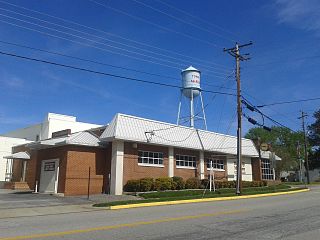
McKenney is an incorporated town in Dinwiddie County, Virginia, United States. The population was 483 at the 2010 census.

Remington is a small incorporated town in Fauquier County, Virginia, United States. The population was 598 at the 2010 census. It is near the highways, U.S. Route 15, U.S. Route 17, U.S. Route 29, and Virginia State Route 28. Remington is less than a mile northeast of the Culpeper County line.
Doswell is an unincorporated community in Hanover County in the Central Region of the U.S. Commonwealth of Virginia. Originally called Hanover Junction, it was located on the Virginia Central Railroad at a crossing of the Richmond, Fredericksburg and Potomac Railroad, a north-south route. Both railroads are now owned by CSX Transportation, although the former Virginia Central line is leased to a short-line carrier, Buckingham Branch Railroad. The area near the Doswell train station is a popular train-watching site for railfans.
Aurelian Springs is an unincorporated community in Halifax County, North Carolina, United States. It is part of the Roanoke Rapids, North Carolina Micropolitan Statistical Area.

Prince George is a census-designated place (CDP) in and the county seat of Prince George County, Virginia, United States. The population as of the 2010 Census was 2,066. It is in the metro area of Richmond, Virginia. The elevation is at 131 feet.
Margarettsville, North Carolina, USA, is an unincorporated community in northern Northampton County. The community is part of the Roanoke Rapids, North Carolina Micropolitan Statistical Area.

Drewryville is an unincorporated community in western Southampton County, Virginia, United States, off U.S. Route 58. It lies at an elevation of 98 feet.
Brooke is an unincorporated community in Stafford County, Virginia, United States.

Uniontown is an unincorporated community in Carroll County, Maryland, United States. The community is home to the Uniontown Historic District, added to the National Register of Historic Places in 1986.
Blackwell is an unincorporated community in Washington County, in the U.S. state of Virginia.
Konnarock is an unincorporated community in Washington County, in the U.S. state of Virginia.
Oak Corner is an unincorporated community in Caroline County, in the U.S. state of Virginia.
Millboro is an unincorporated community in Bath County, Virginia, in the United States.

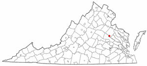
Valentines is an unincorporated community located in Brunswick County, in the U.S. state of Virginia.
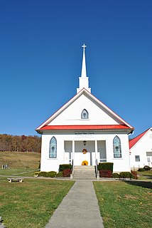
White Plains is an unincorporated community located in Brunswick County, in the U.S. state of Virginia.
Chula is an unincorporated community located in Amelia County, in the U.S. state of Virginia.
Fine Creek Mills is an unincorporated community in Powhatan County, in the U.S. state of Virginia.
Berry Hill is an unincorporated community in Pittsylvania County, in the U.S. state of Virginia. It is the site of an eponymous plantation Berry Hill that was added to the National Register of Historic Places in 1980.
Cascade is an unincorporated community in Pittsylvania County, in the U.S. state of Virginia.
East Lake is an extinct town in New Madrid County, in the U.S. state of Missouri. The GNIS classifies it as a populated place.
References
Municipalities and communities of Brunswick County, Virginia, United States | ||
|---|---|---|
| Towns |  | |
| CDPs | ||
| Unincorporated communities |
| |
| Footnotes | ‡This populated place also has portions in an adjacent county or counties | |
Coordinates: 36°48′25″N77°57′24″W / 36.80694°N 77.95667°W
| This Brunswick County, Virginia state location article is a stub. You can help Wikipedia by expanding it. |