Related Research Articles
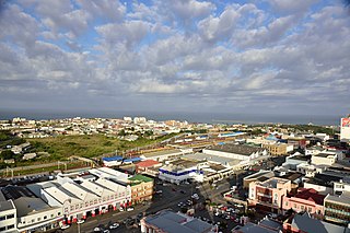
East London is a city on the southeastern coast of South Africa, in the Buffalo City Metropolitan Municipality, Eastern Cape Province. The city lies on the Indian Ocean coast, largely between the Buffalo River and the Nahoon River, and hosts the country's only river port. As of 2011, East London had a population of over 267,000 with over 755,000 in the surrounding metropolitan area.

The R21 is a major north–south provincial route in eastern Gauteng Province, South Africa. Built in the early 1970s, it remains one of two freeways linking Pretoria with Johannesburg, via the R24. As the eastern of the two freeways, it links the Pretoria city centre with OR Tambo International Airport, the N12 freeway, and Boksburg. Between the Solomon Mahlangu Drive on-ramp in Monument Park, Pretoria, and the N12 in Boksburg, the R21 is an 8 lane highway and motorway (freeway), with 4 lanes in each direction. It has off-ramps leading to Irene, Olifantsfontein, Benoni, and Kempton Park, including a partial offramp to Atlas Road. The route intersects the N1 Highway near Centurion, the R24 near the airport, the N12 and N17 in Boksburg, and the N3 near Vosloorus on the East Rand, where it ends. The section from the N12 to the N3 is not a freeway. As early as the 1970s there were proposals to extend the R21 freeway further south and the freeway may be linked with the current eastern terminus of the M2 in Germiston in future. It is also designated as the P157.

The R24 is a major East-West provincial route in the Gauteng and North West provinces that links OR Tambo International Airport with Rustenburg via Johannesburg, Krugersdorp and Magaliesburg. The process of renaming the streets and freeway that form the route from Krugersdorp eastward to OR Tambo International after anti-apartheid stalwart Albertina Sisulu was completed in 2013.

The R75 is a provincial route in Eastern Cape, South Africa that connects Graaff-Reinet with Gqeberha via Despatch, Kariega and Jansenville.

The N2 is a national route in South Africa that runs from Cape Town through George, Gqeberha, East London, Mthatha, Port Shepstone and Durban to Ermelo. It is the main highway along the Indian Ocean coast of the country. Its current length of 2,255 kilometres (1,401 mi) makes it the longest numbered route in South Africa.
In South Africa, a metropolitan municipality or Category A municipality is a municipality which executes all the functions of local government for a city or conurbation. This is by contrast to areas which are primarily rural, where the local government is divided into district municipalities and local municipalities.
The City of Ekurhuleni Metropolitan Municipality is a metropolitan municipality that forms the local government of the East Rand region of Gauteng, a large suburban region east of Johannesburg. Ekurhuleni means "place of peace" in XiTsonga. Ekurhuleni is one of the five districts of Gauteng and one of the eight metropolitan municipalities of South Africa. The seat of Ekurhuleni is Germiston and the most spoken language is Zulu at 28.6%. The city is home to South Africa's busiest airport, OR Tambo International Airport, which is in the Kempton Park area of Ekurhuleni.

The N6 is a national route in South Africa that connects East London with Bloemfontein, via Komani and Maletswai. It runs roughly from north to south, connecting the N1 with the N2.
Metropolitan Routes in Johannesburg, also called Metro Roads or Metro Routes are designated with the letter M, and are usually major routes around Johannesburg and some areas declared part of Greater Johannesburg.
The City of Tshwane like most South African metropolitan areas uses Metropolitan or "M" routes for important intra-city routes, a layer below National (N) roads and Regional (R) roads. Each city's M roads are independently numbered.

In South Africa some roads are designated as numbered routes to help with navigation. There is a nationwide numbering scheme consisting of national, provincial and regional routes, and within various urban areas there are schemes of metropolitan route numbering.

Ethekwini, like most South African metropolitan areas, uses Metropolitan or "M" routes for important intra-city routes, a layer below National (N) roads and Regional (R) roads. Each city's M roads are independently numbered.
The Gauteng Department of Roads and Transport is a department of the Government of Gauteng. It is responsible for the development of the transport system in the Gauteng province of South Africa, and for constructing and maintaining buildings and other structures for the other departments of the provincial government.

The M4 is a long metropolitan route in the City of Cape Town Metropolitan Municipality in South Africa. It connects the Cape Town CBD with the Cape of Good Hope via Wynberg, Muizenberg and Fish Hoek. Originally, it was the main route connecting the Cape Town CBD with the Southern Suburbs. From the CBD to Kirstenhof, it is parallel to the M3 Freeway.

The M6 is a short metropolitan route in Cape Town, South Africa. It connects the Cape Town CBD with Glencairn on the False Bay coast via Sea Point, Camps Bay and Hout Bay. It is an alternative route to the M4 for travel between Cape Town CBD and Glencairn, with the M6 passing to the west of Table Mountain.

The M9 is a long metropolitan route in the City of Cape Town, South Africa. It connects Sir Lowry's Pass Village with Wynberg via Somerset West, Firgrove, Macassar, Khayelitsha and Nyanga.
The M10 is a metropolitan route in the City of Cape Town Metropolitan Municipality, South Africa. It connects the town of Bellville with Philippi on the Cape Flats.
The M12 is a long metropolitan route in the City of Cape Town, South Africa. It connects Burgundy Estate with Stellenbosch via Parow, Elsie's River and Kuils River.

In early January 2022, the Eastern Cape province in South Africa experienced heavy rain and flooding following a thunderstorm that swept away homes, personal belongings and loved ones. These flash floods have left hundreds homeless, especially in township of Mdantsane which is situated on a floodplain making it more vulnerable to these types of natural disasters. Scientists believe that climate change is responsible for the droughts and floods along the eastern coastline. There were 20 casualties from this disaster, including a police rescue diver who, after saving three lives, got caught on a rope and drowned.
The M21 road is a long metropolitan route in the City of Tshwane in Gauteng, South Africa. It connects Ga-Rankuwa with Hammanskraal via Mabopane and Soshanguve.
References
- ↑ "RDDA SOUTH AFRICAN NUMBERED ROUTE DESCRIPTION AND DESTINATION ANALYSIS". NATIONAL DEPARTMENT OF TRANSPORT. May 2012. Retrieved 25 March 2021.
- ↑ "Buffalo City Metropolitan Municipality | ROAD CONSTRUCTIONS COMMENCES IN EAST LONDON AND MDANTSANE". www.buffalocity.gov.za. Retrieved 10 May 2021.
- ↑ "Buffalo City Metropolitan Municipality | South African Government". www.gov.za. Retrieved 10 May 2021.