Metten

Last updated

Metten
Benediktinerabtei Metten-8712.jpg
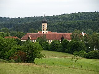
Abbey Church of Saint Michael
DEU Metten COA.svg
Coat of arms
Location of Metten within Deggendorf district
Metten in DEG.svg
Germany adm location map.svg
Red pog.svg
Metten
Bavaria location map.svg
Red pog.svg
Metten
Coordinates: 48°52′N12°55′E / 48.867°N 12.917°E / 48.867; 12.917 Coordinates: 48°52′N12°55′E / 48.867°N 12.917°E / 48.867; 12.917
Country Germany
State Bavaria
Admin. region Niederbayern
District Deggendorf
Subdivisions19 Ortsteile
Government
   Mayor (202026) Andreas Moser [1]
Area
  Total11.91 km2 (4.60 sq mi)
Elevation
318 m (1,043 ft)
Population
 (2020-12-31) [2]
  Total4,204
  Density350/km2 (910/sq mi)
Time zone UTC+01:00 (CET)
  Summer (DST) UTC+02:00 (CEST)
Postal codes
94526
Dialling codes 0991
Vehicle registration DEG
Website www.markt-metten.de

Metten is a municipality in the district of Deggendorf in Bavaria in Germany. The town grew up around the Benedictine Metten Abbey, founded in 766. Metten is also the birthplace of former Bayern Munich goalkeeper Sepp Maier.

Related Research Articles

Deggendorf is a Landkreis (district) in Bavaria, Germany. It is bordered by the districts of Regen, Freyung-Grafenau, Passau, Rottal-Inn, Dingolfing-Landau and Straubing-Bogen.

Vilshofen an der Donau Place in Bavaria, Germany

Vilshofen an der Donau is a town in the German district of Passau.

Regen Place in Bavaria, Germany

Regen is a town in Bavaria, Germany, and the district town of the district of Regen.

Ergolding Place in Bavaria, Germany

Ergolding is a municipality in the district of Landshut, in Bavaria, Germany. It is situated on the left bank of the Isar, 5 km northeast of Landshut.

Mönchsroth Place in Bavaria, Germany

Mönchsroth is a municipality in the district of Ansbach in Bavaria in Germany.

Gessertshausen Place in Bavaria, Germany

Gessertshausen is a municipality in the district of Augsburg in Bavaria in Germany. It lies on the Schmutter River.

Bischofswiesen Place in Bavaria, Germany

Bischofswiesen is a municipality in the district of Berchtesgadener Land in Bavaria in Germany.

Hausen, Upper Franconia Place in Bavaria, Germany

Hausen is a municipality in the district of Forchheim in Bavaria in Germany.

Eching am Ammersee Place in Bavaria, Germany

Eching am Ammersee is a municipality in the district of Landsberg in Bavaria in Germany. It has a size of 6.15km2.

Brannenburg Place in Bavaria, Germany

Brannenburg is a municipality in the district of Rosenheim in Bavaria in Germany. There is a train station is located in Brannenburg.

Flintsbach Place in Bavaria, Germany

Flintsbach is a municipality in the district of Rosenheim in Bavaria in Germany, on the river Inn.

Altenmarkt an der Alz Place in Bavaria, Germany

Altenmarkt an der Alz is a municipality in the district of Traunstein in Bavaria, Germany.

Grabenstätt Place in Bavaria, Germany

Grabenstätt is a municipality in the district of Traunstein in Bavaria, Germany.

Obing Place in Bavaria, Germany

Obing is a municipality in the district of Traunstein in Bavaria, Germany.

Pfaffenhausen Place in Bavaria, Germany

Pfaffenhausen is a municipality in the district of Unterallgäu in Bavaria, Germany. The town is seat of a municipal association with Breitenbrunn, Swabia, Oberrieden, Bavaria and Salgen.

Güntersleben Place in Bavaria, Germany

Güntersleben is a municipality in the district of Würzburg in Bavaria in Germany.

Rotthalmünster Place in Bavaria, Germany

Rotthalmünster is a municipality in the district of Passau in Bavaria in Germany.

Breitbrunn am Chiemsee Place in Bavaria, Germany

Breitbrunn am Chiemsee is a municipality in the district of Rosenheim in Bavaria in Germany.

Höslwang Place in Bavaria, Germany

Höslwang is a municipality in the district of Rosenheim in Bavaria in Germany.

Buxheim, Swabia Place in Bavaria, Germany

Buxheim is a municipality in the district of Unterallgäu in Bavaria, Germany.

References

  1. Liste der ersten Bürgermeister/Oberbürgermeister in kreisangehörigen Gemeinden, Bayerisches Landesamt für Statistik, 15 July 2021.
  2. "Tabellenblatt "Daten 2", Statistischer Bericht A1200C 202041 Einwohnerzahlen der Gemeinden, Kreise und Regierungsbezirke". Bayerisches Landesamt für Statistik und Datenverarbeitung (in German). June 2021.
Panoramic view of Metten Panorama Metten.jpg
Panoramic view of Metten