
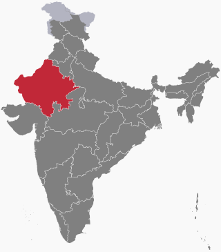
Rajasthan is a state in northwestern India. It covers 342,239 square kilometres (132,139 sq mi) or 10.4 per cent of India's total geographical area. It is the largest Indian state by area and the seventh largest by population. It is on India's northwestern side, where it comprises most of the wide and inhospitable Thar Desert and shares a border with the Pakistani provinces of Punjab to the northwest and Sindh to the west, along the Sutlej-Indus River valley. It is bordered by five other Indian states: Punjab to the north; Haryana and Uttar Pradesh to the northeast; Madhya Pradesh to the southeast; and Gujarat to the southwest. Its geographical location is 23°.3' to 30°.12' North latitude and 69°.30' to 78°.17' East longitude, with the Tropic of Cancer passing through its southernmost tip.

The Aravalli Range is a mountain range in Northern-Western India, running approximately 670 km (420 mi) in a south-west direction, starting near Delhi, passing through southern Haryana, Rajasthan, and ending in Ahmedabad Gujarat. The highest peak is Guru Shikhar on Mount Abu at 1,722 m (5,650 ft). The Aravalli Range is arguably the oldest geological feature on Earth, having its origin in the Proterozoic era.
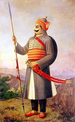
Pratap Singh I, popularly known as Maharana Pratap, was a king of Kingdom of Mewar, in north-western India in the present-day state of Rajasthan. He is notable for leading the Rajput resistance against the expansionist policy of the Mughal Emperor Akbar including the Battle of Haldighati.

Chittorgarh is a major city in the state of Rajasthan in western India. It lies on the Berach River, a tributary of the Banas, and is the administrative headquarters of Chittorgarh District. It was a major stronghold of the Rajput State of Medapata. The city of Chittorgarh is located on the banks of river Gambhiri and Berach.

The Banas is a river which lies entirely within the state of Rajasthan in western India. It is a tributary of the Chambal River, itself a tributary of the Yamuna, which in turn merges into the Ganga. The Banas is approximately 512 kilometres in length.
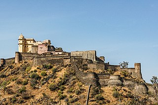
Kumbhalgarh, also known as the Great Wall of India, is a fortress on the westerly range of Aravalli Hills in the Rajsamand district of the Rajasthan state in India. Situated approximately 84 km (52 mi) from Udaipur, it was built during the 15th century by Rana Kumbha. The wall of Kumbhalgarh is the second longest continuous wall in the world, spanning 38 kilometers, second only to the Great Wall of China. It is also the birthplace of great king and military leader Maharana Pratap of Mewar.
Gahlot is a clan of Jats and Rajputs. They ruled a number of kingdoms including Mewar, Banswara, Dungarpur, Pratapgarh, Shahpura, Bhavnagar, Palitana, Lathi and Vala. The variations of the name include Gehlot, or Guhila.

Udaipur district is one of the 50 districts of Rajasthan state in western India. The historic city of Udaipur is the administrative headquarters of the district. The district is part of the Mewar region of Rajasthan.
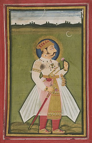
Rana Kumbha or Kumbhkaran Singh (1433–1468), popularly known as Maharana Kumbha, was the ruler of the Kingdom of Mewar. He belonged to the Sisodia clan of Rajputs. It was during his reign that Mewar became one of the most powerful political powers in northern India. He is said to be the most potentially stabled sovereign of his time and his dynasty in general.
Ratnasimha was a ruler of the Medapata (Mewar) kingdom in present-day Rajasthan, India. He belonged to the Rawal branch of the Guhila dynasty, which ruled from the Chitrakuta fort. The last ruler of this branch, he was defeated by Alauddin Khalji during the Siege of Chittorgarh in 1303 CE.
The Chittorgarh, also known as Chittod Fort, is one of the largest living forts in India. It is a UNESCO World Heritage Site. The fort was the capital of Mewar and is located in the present-day city of Chittorgarh. It sprawls over a hill 180 m (590.6 ft) in height spread over an area of 280 ha above the plains of the valley drained by the Berach River. The fort covers 65 historic structures, which include four palaces, 19 large temples, 20 large water bodies, 4 memorials and a few victory towers.
The history of human settlement in the western Indian state of Rajasthan dates back to about 100,000 years ago. Around 5000 to 2000 BCE many regions of Rajasthan belonged as the site of the Indus Valley Civilization. Kalibangan is the main Indus site of Rajasthan, here fire altars have been discovered, similar to those found at Lothal.

The Kingdom of Mewar, sometimes known as Udaipur State, was an independent kingdom in Rajputana region of India, ruled by the Sisodia dynasty. It was established around the 6th century by the minor rulers of the Nagada-Ahar region of Udaipur and later, in the 10th century, it transformed into an independent state under Rawal Bharttripatta II.

Rajasthan is one of the most popular tourist destinations in India, for both domestic and international tourists. Rajasthan attracts tourists for its historical forts, palaces, art and culture with its slogan "Padharo Mhare Desh " The capital city, Jaipur, also known as Pink City, is a very popular tourist destination and is a part of the Golden Triangle. The Walled City of Jaipur is only the second Indian city to be recognized as a UNESCO World Heritage Site, after Ahmedabad.

The Chahamanas of Shakambhari, colloquially known as the Chauhans of Sambhar or Chauhans of Ajmer, were an Indian dynasty that ruled parts of the present-day Rajasthan and neighbouring areas in India, between the 6th and 12th centuries. The territory ruled by them was known as Sapadalaksha. They were the most prominent ruling family of the Chahamana (Chauhan) Rajput clan.
The Guhilas of Medapata colloquially known as Guhilas of Mewar were a Rajput dynasty that ruled the Kingdom of Mewar region in present-day Rajasthan state of India. The Guhila kings initially ruled as Gurjara-Pratihara feudatories between end of 8th and 9th centuries and later were independent in period of the early 10th century and allied themselves with the Rashtrakutas. Their capitals included Nagahrada (Nagda) and Aghata (Ahar). For this reason, they are also known as the Nagda-Ahar branch of the Guhilas.

The Mewar- Malwa conflict was a series of wars between the Kingdom of Mewar and the Islamic Sultanate of Malwa. The conflict erupted due to mutual territorial expansion triggered by both sides on each other. The war was fought in what is now known as the Indian states of Rajasthan and Madhya Pradesh. The Rana branch of the Guhilas, following their successful recovery of the Rajput stronghold of Chittorgarh and the entire region of Mewar alongside Rajputana after the Battle of Singoli, embarked on an ambitious expansion at the cost of their neighboring kingdoms. On the other side, with the invasion of Timur, the Lame Delhi Sultanate grew weak with its multiple subahs gaining independence which included Malwa, adjacent to Mewar.
