West Yorkshire is a metropolitan and ceremonial county in the Yorkshire and the Humber region of England. It is an inland and upland county having eastward-draining valleys while taking in the moors of the Pennines. West Yorkshire came into existence as a metropolitan county in 1974 after the reorganisation of the Local Government Act 1972 which saw it formed from a large part of the West Riding of Yorkshire. The county had a population of 2.3 million in the 2011 census making it the fourth-largest by population in England. The largest towns are Huddersfield, Castleford, Batley, Bingley, Pontefract, Halifax, Brighouse, Keighley, Pudsey, Morley and Dewsbury. The three cities of West Yorkshire are Bradford, Leeds and Wakefield.
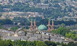
Bingley is a market town and civil parish in the metropolitan borough of the City of Bradford, West Yorkshire, England, on the River Aire and the Leeds and Liverpool Canal, which had a population of 18,294 at the 2011 Census.

The River Aire is a major river in Yorkshire, England, 92 miles (148 km) in length. Part of the river below Leeds is canalised, and is known as the Aire and Calder Navigation.

Riddlesden is a suburb of Keighley in the county of West Yorkshire, England and on the Leeds and Liverpool Canal.

The City of Bradford is a local government district of West Yorkshire, England, with the status of a city and metropolitan borough. It is named after its largest settlement, Bradford, but covers a large area which includes the towns and villages of Keighley, Shipley, Bingley, Ilkley, Haworth, Silsden, Queensbury, Thornton and Denholme. Bradford has a population of 528,155, making it the fourth-most populous metropolitan district and the sixth-most populous local authority district in England. It forms part of the West Yorkshire Urban Area conurbation which in 2011 had a population of 1,777,934, and the city is part of the Leeds-Bradford Larger Urban Zone (LUZ), which, with a population of 2,393,300, is the fourth largest in the United Kingdom after London, Birmingham and Manchester.
Kildwick, or Kildwick-in-Craven, is a village and civil parish of the district of Craven in North Yorkshire, England. It is situated between Skipton and Keighley and had a population of 191 in 2001, rising slightly to 194 at the 2011 census. Kildwick is a landmark as where the major road from Keighley to Skipton crosses the River Aire. The village's amenities include a primary school, church and public house.
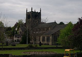
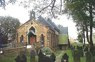
Church of All Saints is the Anglican parish church in the town of Bingley, West Yorkshire, England. It is one of two Anglican churches in the town, the other being Holy Trinity. All Saints has existed since Norman times and it is set in the oldest part of the town, near to where the River Aire is crossed by Ireland Bridge.

Bingley's Ireland Bridge is a Grade II* listed structure and a historically significant crossing point over the River Aire in West Yorkshire, England. It is now the main route between Bingley & the nearby villages of Harden, Wilsden & Cullingworth.

Crossflatts is a ribbon development in Airedale along the old route of the A650 road between Bingley and Keighley, in the Metropolitan Borough of Bradford, West Yorkshire, England. The opening of the Aire Valley Trunk road in 2004 has seen a reduction of 51% of traffic through the village.
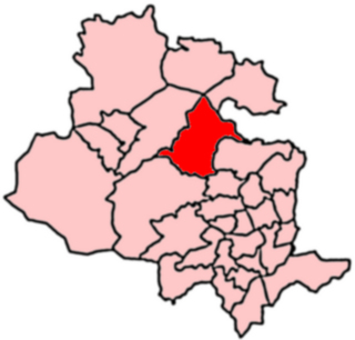
Bingley is a Ward in Bradford Metropolitan District in the county of West Yorkshire, England, named after the town of Bingley around which it is centred.

East Morton is a small village which lies 2 miles (3 km) north of Bingley and 2.5 miles (4 km) east of Keighley, in the county of West Yorkshire, England. The small hamlet of West Morton lies 1 mile (1.6 km) to the north west. The village has a population of 1,169 according to the 2011 census.
Lofthouse is a village between the cities of Wakefield and Leeds in West Yorkshire, England. The village falls within the Ardsley and Robin Hood ward of the City of Leeds Council. It is in the City of Leeds metropolitan borough but with a Wakefield postal address (WF3). It is mentioned as Locthuse, also as Loftose in the 1086 Domesday Book.
Cottingley is a suburban village within the City of Bradford district in West Yorkshire, England between Shipley and Bingley. It is known for the Cottingley Fairies, which appeared in a series of photographs taken there during the early 20th century.

Rodley is a suburb in the City of Leeds metropolitan borough, West Yorkshire, England. The village is situated within the Calverley and Farsley ward of Leeds Metropolitan Council, just inside the Leeds Outer Ring Road, 5 miles (8.0 km) north-west from Leeds city centre and 4 miles (6.4 km) north-east from Bradford. The hamlet of Bagley borders Rodley.

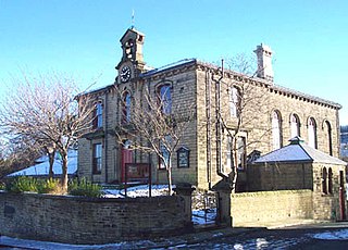
Holy Trinity Church is an Anglican parish church in the town of Bingley, West Yorkshire, England notable for its original church being demolished by explosive charge on 7 April 1974.
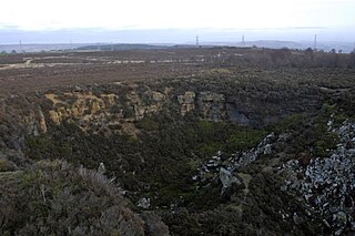
Harden Moor is an expanse of moorland that lies north of the village of Harden in West Yorkshire, England. The moor encompasses stretches of heather, woodland and former quarry workings and is bordered by Airedale to the east, the Worth Valley to the north and Catstones Moor and the village of Cullingworth to the west. Historically, Harden Moor occupied the high ground between Bingley, Keighley, Cullingworth and Harden. Altar Lane, an unmade road which runs from the Brown Cow Inn in Bingley to Keighley Road on Harden Moor is an unofficial border between the estate of St Ives and Harden Moor, but when the St Ives Estate was created, a large swathe of Harden Moor was taken over.

Hainworth is a hamlet 1 mile (2 km) south of Keighley in West Yorkshire, England. The hamlet faces north across the lower end of the Worth Valley with a steep wooded incline towards Keighley.

Bingley Urban District covered the town of Bingley, West Riding of Yorkshire, England, and its surrounding areas for 80 years between 1894 and 1974. It had replaced an Improvement Commissioners council, and the UDC itself was replaced in 1974, by the newly formed Bradford Metropolitan District Council. The urban district council had responsibility for many local interests, including fire service and medical provision, that are now the remit of regional or national agencies.

Nesfield is a small village, 2 miles (3.2 km) north-west of Ilkley on the north bank of the River Wharfe, in the civil parish of Nesfield with Langbar, in the Harrogate district, in the county of North Yorkshire, England. Historically in the West Riding of Yorkshire, the village sits at the southern edge of the Nidderdale Area of Outstanding Natural Beauty.

Newlay is a suburb of Horsforth, in West Yorkshire, England. Originally a hamlet, it is now part of Horsforth parish in the City of Leeds District, and has its own conservation area. Newlay is situated on the Leeds and Liverpool Canal and the River Aire, some 5 miles (8 km) north west of Leeds city centre.
