Related Research Articles

An automotive navigation system is part of the automobile controls or a third party add-on used to find direction in an automobile. It typically uses a satellite navigation device to get its position data which is then correlated to a position on a road. When directions are needed routing can be calculated. On the fly traffic information can be used to adjust the route.

Microsoft MapPoint is a discontinued software program and service created by Microsoft that allows users to view, edit and integrate maps. The software and technology are designed to facilitate the geographical visualization and analysis of either included data or custom data. Numerous acquisitions have supplemented both data and feature integration.
Microsoft Streets & Trips, known in other countries as Microsoft AutoRoute, is a discontinued mapping program developed and distributed by Microsoft. Functionally, the last version is a subset of Microsoft MapPoint targeted at the average consumer to do a variety of map related tasks in the North American region including the United States, Canada, and Mexico, such as route planning.
OpenStreetMap (OSM) is a free, open geographic database updated and maintained by a community of volunteers via open collaboration. Contributors collect data from surveys, trace from aerial imagery and also import from other freely licensed geodata sources. OpenStreetMap is freely licensed under the Open Database License and as a result commonly used to make electronic maps, inform turn-by-turn navigation, assist in humanitarian aid and data visualisation. OpenStreetMap uses its own topology to store geographical features which can then be exported into other GIS file formats. The OpenStreetMap website itself is an online map, geodata search engine and editor.
A mini-map or minimap is a miniature map that is often placed at a screen corner in video games to aid players in orienting themselves within the game world. They are often only a small portion of the screen and must be selective in what details they display. Elements usually included on mini-maps vary by video game genre. However, commonly included features are the position of the player character, allied units or structures, enemies, objectives, and surrounding terrain.
Navteq was an American Chicago-based provider of geographic information system (GIS) data and a major provider of base electronic navigable maps. The company was acquired by Nokia in 2007–2008, and fully merged into Nokia in 2011 to form part of the Here business unit. The unit was subsequently sold to a consortium of German auto makers in 2016.

TomTom N.V. is a Dutch multinational developer and creator of location technology and consumer electronics. Founded in 1991 and headquartered in Amsterdam, TomTom released its first generation of satellite navigation devices to market in 2004. As of 2019 the company has over 4,500 employees worldwide and operations in 29 countries throughout Europe, Asia-Pacific, and the Americas.
Satellite navigation software or GPS navigation software usually falls into one of the following two categories:
- Navigation with route calculation and directions from the software to the user of the route to take, based on a vector-based map, normally for motorized vehicles with some motorized forms added on as an afterthought.
- Navigation tracking, often with a map "picture" in the background, but showing where you have been, and allowing "routes" to be preprogrammed, giving a line you can follow on the screen. This type can also be used for geocaching.
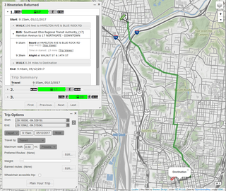
A journey planner, trip planner, or route planner is a specialized search engine used to find an optimal means of travelling between two or more given locations, sometimes using more than one transport mode. Searches may be optimized on different criteria, for example fastest, shortest, fewest changes, cheapest. They may be constrained, for example, to leave or arrive at a certain time, to avoid certain waypoints, etc. A single journey may use a sequence of several modes of transport, meaning the system may know about public transport services as well as transport networks for private transportation. Trip planning or journey planning is sometimes distinguished from route planning, which is typically thought of as using private modes of transportation such as cycling, driving, or walking, normally using a single mode at a time. Trip or journey planning, in contrast, would make use of at least one public transport mode which operates according to published schedules; given that public transport services only depart at specific times, an algorithm must therefore not only find a path to a destination, but seek to optimize it so as to minimize the waiting time incurred for each leg. In European Standards such as Transmodel, trip planning is used specifically to describe the planning of a route for a passenger, to avoid confusion with the completely separate process of planning the operational journeys to be made by public transport vehicles on which such trips are made.

A satellite navigation device is a user equipment that uses one or more of several global navigation satellite systems (GNSS) to calculate the device's geographical position and provide navigational advice. Depending on the software used, the satnav device may display the position on a map, as geographic coordinates, or may offer routing directions.
Here Technologies is an American–Dutch multinational group dealing with mapping, location data and related automotive services to individuals and companies. It is majority-owned by a consortium of German automotive companies and American semiconductor company Intel whilst other companies also own minority stakes. Its roots date back to U.S.-based Navteq in 1985, which was acquired by Finland-based Nokia in 2007. Here is currently based in The Netherlands.

TeleType Co., Inc. is a privately held company in the United States, specialized in developing software for GPS devices. It was founded in 1981, under the name TeleTypesetting Company and it is based in Boston, Massachusetts. The company's product line includes automotive and commercial GPS navigation systems and other products including GPS receivers and tracking units. It develops and sells the WorldNav software for PC and Windows CE, tools for converting third party maps into WorldNav maps, an SDK and an API that allow the customization of the WorldNav application. TeleType Co. also offers consultancy services for those interested in acquiring and adapting the source code of their software products.
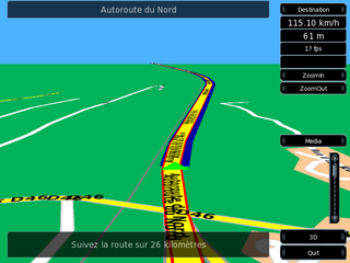
Turn-by-turn Navigation is a feature of some satellite navigation devices where directions for a selected route are continually presented to the user in the form of spoken or visual instructions. The system keeps the user up-to-date about the best route to the destination, and is often updated according to changing factors such as traffic and road conditions. Turn-by-turn systems typically use an electronic voice to inform the user whether to turn left or right, the street name, and the distance to the next turn.
Telenav, Inc. is a wireless location-based services corporation that provides services including Global Positioning System (GPS) satellite navigation, local search, automotive navigation solutions, mobile advertising, enterprise mobility and workflow automation. The company’s headquarters are located in Santa Clara, California in the United States with additional offices in the U.S., Germany, Japan, Romania, China, and Brazil.

Toyota Entune is an integrated multimedia navigation and telematics system for Toyota automobiles that provides satellite-based information on traffic, weather, sports scores, stocks, and fuel prices via subscription through SiriusXM. When connected to a compatible cellular phone running the Entune app via radio or USB cable, the system provides a browser and other apps including those from music services such as iHeartRadio, Pandora, and XM Satellite Radio. The cell phone app has iOS, Android, and Blackberry versions; to use this feature, a cell phone data plan is required. The system can be controlled with voice recognition, and may include the “Safety Connect” personalization system.
OsmAnd is a map and navigation app for Android and iOS. It uses the OpenStreetMap (OSM) map database for its primary displays, but is an independent app not endorsed by the OpenStreetMap Foundation. It is available in both free and paid versions; the latter unlocks the download limit for offline maps and provides access to Wikipedia points of interest (POIs) and their descriptions from within the app. Map data can be stored on the device for offline use. Using the device's GPS capabilities, OsmAnd offers routing, with visual and voice guidance, for car, bike, and pedestrian. All of the main functionalities work both online and offline.
Microsoft mobile services are a set of proprietary mobile services created specifically for mobile devices, they are typically offered through mobile applications and mobile browser for Windows Phone, | platforms, BREW, and Java. Microsoft's mobile services are typically connected with a Microsoft account and often come preinstalled on Microsoft's own mobile operating systems while they are offered via various means for other platforms. Microsoft started to develop for mobile computing platforms with the launch of Windows CE in 1996 and later added Microsoft's Pocket Office suite to their Handheld PC line of PDAs in April 2000. From December 2014 to June 2015, Microsoft made a number of corporate acquisitions, buying several of the top applications listed in Google Play and the App Store including Acompli, Sunrise Calendar, Datazen, Wunderlist, Echo Notification Lockscreen, and MileIQ.
Roadtrippers is a web based software application, mobile app, and content provider that helps travelers plan road trips. The software lets users discover independently owned points of interest in the United States and Canada. Once a trip is saved, it can be synced to the Roadtrippers iPhone app, for turn-by-turn navigation, and further local discovery while on the road.

Map matching is the problem of how to match recorded geographic coordinates to a logical model of the real world, typically using some form of Geographic Information System. The most common approach is to take recorded, serial location points and relate them to edges in an existing street graph (network), usually in a sorted list representing the travel of a user or vehicle. Matching observations to a logical model in this way has applications in satellites navigation, GPS tracking of freight, and transportation engineering.
Windows Maps is a web mapping client software from Microsoft. It is included with Windows 11 and Windows 10 operating systems and is also available for the Xbox Series X/S and Xbox One platforms.
References
- 1 2 3 4 "Try AutoRoute for Free". microsoft.com. Microsoft . Retrieved 8 July 2014.
- ↑ Popa, Bogdan (7 July 2014). "Microsoft Kills Three More Software Products". Softpedia . SoftNews.
- ↑ Thurrott, Paul (7 July 2014). "MapPoint and Streets & Trips Step Aside for Bing Maps". Paul Thurrott's SuperSite for Windows. Penton Media. Archived from the original on 16 November 2016. Retrieved 8 July 2014.
- ↑ "History of AutoRoute and Streets & Trips". Archived from the original on 2016-02-24. Retrieved 2020-04-20.
- ↑ Microsoft Autoroute homepage
- ↑ AutoRoute GPS homepage