
A chambered cairn is a burial monument, usually constructed during the Neolithic, consisting of a sizeable chamber around and over which a cairn of stones was constructed. Some chambered cairns are also passage-graves. They are found throughout Britain and Ireland, with the largest number in Scotland.

The court cairn or court tomb is a megalithic type of chambered cairn or gallery grave. During the period, 3900–3500 BC, more than 390 court cairns were built in Ireland and over 100 in southwest Scotland. The Neolithic monuments are identified by an uncovered courtyard connected to one or more roofed and partitioned burial chambers. Many monuments were built in multiple phases in both Ireland and Scotland and later re-used in the Early Bronze Age.

Kilmartin Glen is an area in Argyll north of Knapdale. It has the most important concentration of Neolithic and Bronze Age remains in mainland Scotland. The glen is located between Oban and Lochgilphead, surrounding the village of Kilmartin. In the village, Kilmartin Museum explains the stories of this ancient landscape and the people who dwelt there. There are more than 800 ancient monuments within a six-mile (ten-kilometre) radius of the village, with 150 monuments being prehistoric. Monuments include standing stones, a henge monument, numerous cists, and a "linear cemetery" comprising five burial cairns. Several of these, as well as many natural rocks, are decorated with cup and ring marks.

The Standing Stones of Torhouse are a stone circle of nineteen granite boulders on the land of Torhouse, three miles west of Wigtown, Scotland.

New Luce is a civil parish in Dumfries and Galloway, south-west Scotland. It lies in the traditional county of Wigtownshire, and is about 10 miles (16 km) in length and 5 miles (8.0 km) in breath, being the upper part of the original Glenluce Parish. New Luce is shown as a civil parish on John Ainslie's county map of 1782.
Dunragit is a village on the A75, between Stranraer and Glenluce in Dumfries and Galloway, south-west Scotland. Dunragit is within the parish of Old Luce, in the traditional county of Wigtownshire. The modern village grew up around the west gate of Dunragit House, an 18th-century country house, though there is evidence of Neolithic settlement in the area.

Parc Cwm long cairn, also known as Parc le Breos burial chamber, is a partly restored Neolithic chambered tomb, identified in 1937 as a Severn-Cotswold type of chambered long barrow. The cromlech, a megalithic burial chamber, was built around 5850 years before present (BP), during the early Neolithic. It is about seven 1⁄2 miles (12 km) west south–west of Swansea, Wales, in what is now known as Coed y Parc Cwm at Parc le Breos, on the Gower Peninsula.

Bargrennan is a village in Dumfries and Galloway, in the south west of Scotland. It is located 9 miles northwest of Newton Stewart by the River Cree and on the A714 road to Girvan. The Southern Upland Way runs through the village and the Glentrool Forest, managed by the Forestry Commission, is to the north-east of the village.
Old Luce is a civil parish in Dumfries and Galloway, Scotland. It lies in the Machars peninsula, in the traditional county of Wigtownshire. The parish is around 10 miles (16 km) long and 8 miles (13 km) broad, and contains 40,350 acres (16,330 ha).
The Pettigarths Field Cairns is a Neolithic site in the parish of Nesting, northeastern Whalsay, in the Shetland islands of Scotland. It is located approximately 140 metres (460 ft) to the northwest of Benie Hoose. The site contains upright stones as well as masonry. The south cairn is roughly 6 metres (20 ft) square, with an eastern entrance passage and circular chamber about 2 metres across. 4 metres (13 ft) to the north is a round cairn, 4.5 metres (15 ft) in diameter, with a rectangular cist. The two cairns are located on a rise, about 140 metres (460 ft) northwest of Benie Hoose.


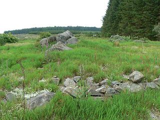
Bargrennan chambered cairns are a class of prehistoric chambered cairns found only in south-west Scotland, in western Dumfries and Galloway and southern Ayrshire. They form a separate group from the Clyde cairns which are found along the coast of western Britain. Unlike Clyde cairns, Bargrennan monuments are passage graves, with one or more chambers set into a round cairn. As well as being structurally different, Bargrennan cairns are separated from Clyde cairns by their siting and distribution; they are found in upland, inland areas of Galloway and Ayrshire. Murray suggests that there are around twelve Bargrennan monuments in south-west Scotland. She also notes that as sheep rees are often built into and over these types of cairns, more are likely to have been lost under shepherd's buildings.
Pict's Knowe is a henge monument in the parish of Troqueer, Dumfries and Galloway. It is one of a small group of henge monuments around Dumfries which includes Broadlea henge near Annan. Pict's Knowe is located 4 km SW of Dumfries on a small sandy bank in the peat covered valley of the Crooks Pow stream.
Curriestanes cursus is a large neolithic ditched enclosure on the outskirts of Dumfries, in the parish of Troqueer, Dumfries and Galloway. It is visible only from aerial photography. It is, along with Pict's Knowe, one of two scheduled monuments in Troqueer parish.
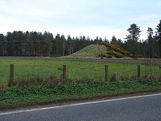
Droughdool Mote is a Neolithic round mound in the parish of Old Luce, Wigtownshire, Dumfries and Galloway. The mound is oval in plan, measuring 60m by 50m at its base and rises to 10m in height. It is located 400m south of the late neolithic palisaded enclosure at Dunragit. It has been suggested that the mound may have been used as a viewing platform for activities at Dunragit complex of monuments. The most well known parallel the site has is Silbury Hill in Wiltshire, but is closer in size to the less well known sites at Conquer Barrow, Willy Howe and Wold Newton. The mound was originally built with stepped sides on top of a sand dune. Excavation between 1999-2002 revealed a round cairn at the top of the mound, similar to the nearby Mid Gleniron A.
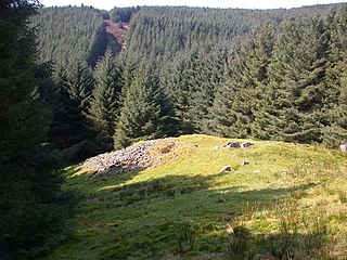
Cairnderry chambered cairn is a chambered cairn in Dumfries and Galloway. It is a Bargrennan cairn, a type of Neolithic or early Bronze Age monument only found in south west Scotland.

Huntersquoy chambered cairn is a Neolithic chambered cairn located on the island of Eday, in Orkney, Scotland. The monument dates from the 3rd millennium BC and is an Orkney–Cromarty type chambered cairn. Huntersquoy is a distinctive two-story burial monument with overlapping chambers. Historic Environment Scotland established the site as a scheduled monument in 1936.

Braeside chambered cairn is a Neolithic burial monument located on the island of Eday in Orkney, Scotland. It is an Orkney-Cromarty type stalled cairn, similar in construction to the Midhowe Chambered Cairn on the island of Rousay. Because of prior robbing, the Braeside cairn has been reduced to a few upright stones at the ground level, covered with turf and heather. The cairn is located on the Eday Heritage Trail.

