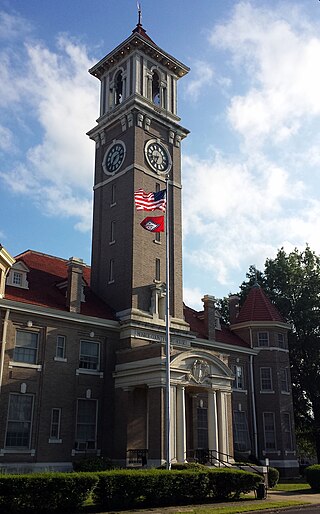
Monroe County is located in the Arkansas Delta in the U.S. state of Arkansas. The county is named for James Monroe, the fifth President of the United States. Created as Arkansas's 20th county on November 2, 1829, Monroe County is home to two incorporated towns and three incorporated cities, including Clarendon, the county seat, and Brinkley, the most populous city. The county is also the site of numerous unincorporated communities and ghost towns.
Hamilton is a census-designated place and unincorporated community in Monroe County, Mississippi, United States. As of the 2020 census, it had a population of 404.
Rocky Comfort is an unincorporated community and census-designated place in McDonald County, Missouri, United States, on Missouri Route 76. As of the 2020 census, it had a population of 176.
Dawn is an unincorporated community and census-designated place (CDP) in Livingston County, Missouri, United States. As of the 2020 census it had a population of 100.
Harviell is an unincorporated community and census-designated place in Butler County, Missouri, United States. As of the 2020 census it had a population of 98.
Philadelphia is an unincorporated community and census-designated place in western Marion County, Missouri, United States. It is located 12 miles (19 km) west of Palmyra on Missouri Route 168. The community is part of the Hannibal Micropolitan Statistical Area.
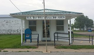
Fortuna is an unincorporated community and census-designated place in Moniteau County, Missouri, United States. As of the 2020 census, the population was 130.
Latham is an unincorporated community and census-designated place in Moniteau County, Missouri, United States. As of the 2020 census, it had a population of 69.

Ida is an unincorporated community and census-designated place (CDP) in Monroe County in the U.S. state of Michigan. The CDP had a population of 790 at the 2020 census. The community is mostly within Ida Township with a smaller portion extending north into Raisinville Township.
North Grove is an unincorporated community and census-designated place (CDP) in Harrison Township, Miami County, in the U.S. state of Indiana.

Stanford is an unincorporated community and census-designated place (CDP) in Van Buren Township, Monroe County, in the U.S. state of Indiana.

Falmouth is an unincorporated community and census-designated place (CDP) in Missaukee County in the U.S. state of Michigan. The community is located within Clam Union Township. Its population was 183 at the 2020 census.

Kingston is an unincorporated community and census-designated place (CDP) in northeast Madison County, Arkansas, United States. It was first listed as a CDP in the 2020 census with a population of 97.
Goss is a village in Monroe County, Missouri, United States; it was once incorporated as a town, but reclassified as a village in 2010. According to the 2020 census, the village has no permanent residents.
Wesley is an unincorporated community and census-designated place (CDP) in western Madison County, Arkansas, United States. Wesley is located at the junction of Arkansas highways 74 and 295, 13 miles (21 km) by road west-southwest of Huntsville. Wesley has a post office with ZIP code 72773. It was first listed as a CDP in the 2020 census with a population of 161.
Monroe is an unincorporated community and census-designated place (CDP) in Monroe County, Arkansas, United States. The unincorporated community extends beyond the CDP slightly into Lee County. It was first listed as a CDP in the 2020 census with a population of 51.
Indian Bay is an unincorporated community and census-designated place (CDP) in southern Monroe County, Arkansas, United States, in the Arkansas Delta. Indian Bay is on the eastern bank of the White River, 4 miles (6 km) east of St. Charles. For purposes of the U.S. Census, Indian Bay is within Montgomery-Smalley Township. The Baytown Site, a Pre-Columbian Native American archaeological site, is located near Indian Bay. The community was first listed as a CDP in the 2020 census with a population of 15.
Whiting is an unincorporated community and census-designated place in Mississippi County, in the U.S. state of Missouri. As of the 2020 census, the population was 155.
Encore at Monroe is a gated community and census-designated place (CDP) located in Monroe Township, Middlesex County, in the U.S. state of New Jersey. It is in the western part of the township, bordered to the south by Clearbrook. It is 3 miles (5 km) southwest of Jamesburg, 15 miles (24 km) south of New Brunswick, 6 miles (10 km) northeast of Hightstown, and 18 miles (29 km) northeast of Trenton.
Renaissance at Monroe is a planned community and census-designated place (CDP) in Monroe Township, Middlesex County, in the U.S. state of New Jersey. It is in the southwest part of the township, bordered to the east by Monroe Manor and to the east by East Windsor Township in Mercer County. New Jersey Route 33 forms the northern edge of the community; it is 1.5 miles (2.4 km) west to Exit 8 on the New Jersey Turnpike and 11 miles (18 km) east to Freehold.


