In Downtown Atlanta, the Downtown Connector or 75/85 is the concurrent section of Interstate 75 and Interstate 85 through the core of the city. Beginning at the I-85/Langford Parkway interchange, the Downtown Connector runs generally due north, meeting the west–east I-20 in the middle. Just north of this is the Grady Curve around Grady Memorial Hospital. Continuing north, the terminus of the Downtown Connector is the Brookwood Interchange or Brookwood Split in the Brookwood area of the city. The overall length of the Downtown Connector is approximately 7.5 miles (12 km). Since the 2000s, it has been officially named James Wendell George Parkway for most of its length, although it is still designated the Connector in the mainstream. It also has unsigned designations State Route 401 (I-75) and State Route 403 (I-85) along its length, due to I-75 and I-85 having 400-series reference numbers.
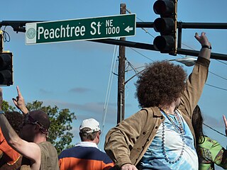
Peachtree Street is one of several major streets running through the city of Atlanta, Georgia, United States. Beginning at Five Points in downtown Atlanta, it runs North through Midtown; a few blocks after entering into Buckhead, the name changes to Peachtree Road at Deering Road. Much of the city's historic and noteworthy architecture is located along the street, and it is often used for annual parades,, as well as one-time parades celebrating events such as the 100th anniversary of Coca-Cola in 1986 and the Atlanta Braves' 1995 and 2021 World Series victories.
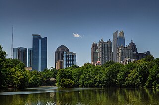
Midtown Atlanta, or Midtown, is a high-density commercial and residential neighborhood of Atlanta, Georgia. The exact geographical extent of the area is ill-defined due to differing definitions used by the city, residents, and local business groups. However, the commercial core of the area is anchored by a series of high-rise office buildings, condominiums, hotels, and high-end retail along Peachtree Street between North Avenue and 17th Street. Midtown, situated between Downtown to the south and Buckhead to the north, is the second-largest business district in Metro Atlanta. In 2011, Midtown had a resident population of 41,681 and a business population of 81,418.

Buckhead is the uptown commercial and residential district of the city of Atlanta, Georgia, comprising approximately the northernmost fifth of the city. Buckhead is the third largest business district within the Atlanta city limits, behind Downtown and Midtown, and a major commercial and financial center of the Southeast.

State Route 141 (SR 141) is a 34.1-mile-long (54.9 km) state highway that runs southwest-to-northeast in the northwest part of the U.S. state of Georgia. It connects the Buckhead area of Atlanta with Cumming. Its routing exists within portions of Fulton, DeKalb, Gwinnett, Forsyth counties.

Lenox Square is a shopping mall in the Buckhead district of Atlanta, Georgia. With 198 tenants and 1,558,678 square feet (144,805.9 m2) of gross leasable area, it is the third-largest mall in Georgia. The mall is currently owned and managed by Simon Property Group, and is considered a sister mall to the adjacent, Simon-owned Phipps Plaza. The mall features Macy's, Bloomingdale's, and Neiman Marcus.
The Atlanta BeltLine is a 22 miles (35 km) open and planned loop of multi-use trail and light rail transit system on a former railway corridor around the core of Atlanta, Georgia. The Atlanta BeltLine is designed to reconnect neighborhoods and communities historically divided and marginalized by infrastructure, improve transportation, add green space, promote redevelopment, create and preserve affordable housing, and showcase arts and culture. The project is in varying stages of development, with several mainline and spur trails complete and others in an unpaved, but hikeable, state. Since the passage of the More MARTA sales tax in 2016, construction of the light rail streetcar system is overseen by MARTA in close partnership with Atlanta BeltLine, Inc.

State Route 13 (SR 13) is a 49.5-mile-long (79.7 km) state highway in the north-central part of the U.S. state of Georgia, that travels through portions of Fulton, DeKalb, Gwinnett, and Hall counties.

Downtown Atlanta is the central business district of Atlanta, Georgia, United States. The larger of the city's two other commercial districts, it is the location of many corporate and regional headquarters; city, county, state, and federal government facilities; Georgia State University; sporting venues; and most of Atlanta's tourist attractions. It measures approximately four square miles, and had 26.850 residents as of 2017. Similar to other central business districts in the United States, it has recently undergone a transformation that includes the construction of new condos and lofts, renovation of historic buildings, and arrival of new residents and businesses.

Arts Center station is a train station in Atlanta, Georgia, serving the Red and Gold lines of the Metropolitan Atlanta Rapid Transit Authority (MARTA) rail system. It is the northernmost of three MARTA stations that serve Midtown Atlanta, the others being Midtown and North Avenue.

Brookwood Hills is a historic neighborhood located in intown Atlanta, Georgia, United States, north of Midtown and south-southwest of Buckhead. Home to about 1000 people, it was founded in the early 1920s by Benjamin Franklin Burdett and his son, Arthur. The site of the neighborhood is located where some of the bloodiest battles of the American Civil War took place during the Atlanta Campaign.

SoNo is a sub-district of downtown Atlanta, Georgia, just south of Midtown. The area was defined and named by T. Brian Glass while working on a rezoning committee with Central Atlanta Progress in 2005 in order to better establish an identity for the area and give it a hipper image. SoNo refers to the area of Downtown bounded by North Avenue on the north, Central Park Place on the east and the Downtown Connector (Interstate-75/85) on the west and south.

Ponce de Leon Avenue, often simply called Ponce, provides a link between Atlanta, Decatur, Clarkston, and Stone Mountain, Georgia. It was named for Ponce de Leon Springs, in turn from explorer Juan Ponce de León, but is not pronounced as in Spanish. Several grand and historic buildings are located on the avenue.

Capitol View is a historic in-town southwest Atlanta neighborhood 2.5 miles from downtown Atlanta, Georgia that was named for its view of the Georgia State Capitol building. Its boundaries include Metropolitan Parkway to the east, Lee Street to the west, and the Beltline to the north. On the south, the border follows Arden Street, Deckner Avenue, and Perkerson Park.

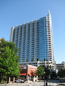
1010 Midtown is a 35-story, 124 m (407 ft) skyscraper in Atlanta, Georgia with 425 condominiums atop 38,000 sq ft (3,500 m2) of retail and dining space. The structure is part of the 12th & Midtown development, situated on approximately 2 acres (0.81 ha) on the block between 11th and 12th streets in Midtown Atlanta, the front of which follows the curve of Peachtree Street. The 1010 Midtown building also features a park-in-the-sky, which will be one of the largest environmentally green rooftops in the city.

U.S. Highway 19 (US 19) is a 349-mile-long (562 km) United States Numbered Highway in the U.S. state of Georgia. It travels from the Florida state line south-southeast of Thomasville through Albany and Atlanta, to the North Carolina state line at a point north of Lake Nottely.

Streetcars originally operated in Atlanta downtown and into the surrounding areas from 1871 until the final line's closure in 1949.
12th and Midtown is a four-block commercial real estate development project in Midtown Atlanta along Peachtree Street and Crescent Avenue between 11th and 13th Streets. The development currently contains three of the tallest buildings in Midtown, with more buildings planned in the coming years.
Atlanta's transportation system is a complex infrastructure of several systems, including 47.6 miles of heavy rail, 91 bus transit routes, 1,600 licensed taxis, a comprehensive network of freeways, the world's busiest airport and over 45 miles of bike paths.
Piedmont Avenue is a major thoroughfare in Atlanta, beginning in Downtown Atlanta and ending at its continuation as Piedmont Road just before crossing under Interstate 85. Along the way, Piedmont Avenue passes through Midtown Atlanta where several historic properties are located on the street.