White City is a town in the southeast Saskatchewan. Situated at the intersection of Highway 48 and the Trans-Canada Highway, the town is part of the White Butte region and neighbours Balgonie, Pilot Butte, and the province's capital city, Regina. White City is primarily populated by people who commute to work in Regina. It’s motto is "Your Way of Life".

Annaheim is a village in the Canadian province of Saskatchewan within the Rural Municipality of St. Peter No. 369 and Census Division No. 15. The village is located about 125 km east of the City of Saskatoon, at the junction of provincial Highway 756 and Highway 779. Annaheim hosts the offices of the Rural Municipality of St. Peter No. 369.
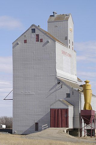
Quill Lake is a village in the Canadian province of Saskatchewan within the Rural Municipality of Lakeside No. 338 and Census Division No. 10. It is 170 km east of Saskatoon and 200 km northeast of Regina on Highway 5.

Glen Ewen is a village in the Canadian province of Saskatchewan within the Rural Municipality of Enniskillen No. 3 and Census Division No. 1. The village is located on the Canadian Pacific Railway just south of Provincial Highway 18. The towns of Carnduff and Oxbow are nearby.
Wilcox is a village in the Canadian province of Saskatchewan within the Rural Municipality of Bratt's Lake No. 129 and Census Division No. 6. It is approximately 41 kilometres (25 mi) south of the City of Regina.
Heward is a village in the Canadian province of Saskatchewan within the Rural Municipality of Tecumseh No. 65 and Census Division No. 1. The village is located along highway 33 in southeastern Saskatchewan. Even though it has under 50 people it still maintains a post office, rink, and hall that all service the farming community. In 1977 Prairie Trails and Tales: Heward Saskatchewan 1900-1976 was written by Muriel Dempsey.
Choiceland is a town located in Saskatchewan, Canada. Choiceland is located an hour or so from Prince Albert, a larger Saskatchewan city.
Lemberg is a town in Saskatchewan, Canada. It was founded by ethnic German immigrants from Lviv, for which the German name was "Lemberg" as part of the Great Economic Emigration away from Galicia and Lodomeria.
Dilke is a village in the Canadian province of Saskatchewan within the Rural Municipality of Sarnia No. 221 and Census Division No. 6.
Duval is a village in the Canadian province of Saskatchewan within the Rural Municipality of Last Mountain Valley No. 250 and Census Division No. 11. The village is located on Highway 20 approximately 93 km north of the City of Regina.
Edenwold is a village in the Canadian province of Saskatchewan within the Rural Municipality of Edenwold No. 158 and Census Division No. 6. It is located 45 km (28 mi) north of the City of Regina.
Grand Coulee is a town in the Canadian province of Saskatchewan. It is located 18 km (11 mi) west of downtown Regina. It is home to an annual event called "The Hoe Down".
Lake Lenore is a village in the Canadian province of Saskatchewan within the Rural Municipality of St. Peter No. 369 and Census Division No. 15. The village is located 144 kilometres (89 mi) northeast of the city of Saskatoon. To the north of the village is Lenore Lake, which is designated as a migratory bird sanctuary, an Important Bird Area (IBA) of Canada, and has a National Wildlife Area on Raven Island. Services in Lake Lenore include a school, Co-op Grocery and Agro Service Station, a Credit Union, and Public Library.
Lang is a village in the Canadian province of Saskatchewan within the Rural Municipality of Scott No. 98 and Census Division No. 2. The village is located approximately 70 km southeast of the City of Regina.
Lintlaw is a village in the Canadian province of Saskatchewan within the Rural Municipality of Hazel Dell No. 335 and Census Division No. 9. The village is located at the intersection of Highway 49 and Highway 617, 142 km northwest of the City of Yorkton.
McTaggart is a village in the Canadian province of Saskatchewan within the Rural Municipality of Weyburn No. 67 and Census Division No. 2.
Minton is a village in the Canadian province of Saskatchewan within the Rural Municipality of Surprise Valley No. 9 and Census Division No. 2. It is on Highway 6 just north of its intersection with Highway 18, 19 km north of the Raymond-Regway Border Crossing on the Montana-Saskatchewan border. The village was named after Minton, Shropshire in England. The name was given by the Canadian Pacific Railway.
Valparaiso is a village in the Canadian province of Saskatchewan within the Rural Municipality of Star City No. 428 and Census Division No. 14. The village is located at the junction of Highway 3 and Range Road No. 160, approximately 20 km east of the City of Melfort. The name comes from that of Valparaíso in Chile.
Ceylon is a village in the Canadian province of Saskatchewan within the Rural Municipality of The Gap No. 39 and Census Division No. 2. It is located alongside Gibson Creek, which is a tributary of Long Creek. No shops or businesses other than the bar remain.
Osage is a village in the Canadian province of Saskatchewan within the Rural Municipality of Fillmore No. 96 and Census Division No. 2. The village is located on Highway 33, that runs south-east from Regina to Stoughton. The village has a grain elevator, post office, service station, and a two-sheet natural ice curling rink. Children from the area attend school in Fillmore, 13 km away. Osage celebrated its centennial in 2006.