
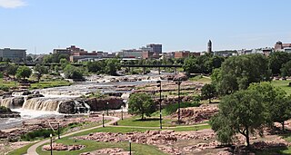
South Dakota is a U.S. state in the North Central region of the United States. It is also part of the Great Plains. South Dakota is named after the Dakota Sioux Native American tribe, which comprises a large portion of the population with nine reservations currently in the state and has historically dominated the territory. South Dakota is the 17th largest by area, but the 5th least populous, and the 5th least densely populated of the 50 United States. As the southern part of the former Dakota Territory, South Dakota became a state on November 2, 1889, simultaneously with North Dakota. They are the 39th and 40th states admitted to the union; President Benjamin Harrison shuffled the statehood papers before signing them so that no one could tell which became a state first. Pierre is the state capital, and Sioux Falls, with a population of about 192,200, is South Dakota's most populous city.
The Lakota are a Native American people. Also known as the Teton Sioux, they are one of the three prominent subcultures of the Sioux people, with the Eastern Dakota (Santee) and Western Dakota (Wičhíyena). Their current lands are in North and South Dakota. They speak Lakȟótiyapi—the Lakota language, the westernmost of three closely related languages that belong to the Siouan language family.
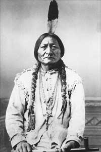
The Sioux or Oceti Sakowin are groups of Native American tribes and First Nations peoples from the Great Plains of North America. The Sioux have two major linguistic divisions: the Dakota and Lakota peoples. Collectively, they are the Očhéthi Šakówiŋ, or "Seven Council Fires". The term "Sioux", an exonym from a French transcription ("Nadouessioux") of the Ojibwe term "Nadowessi", can refer to any ethnic group within the Great Sioux Nation or to any of the nation's many language dialects.

South Dakota State University (SDSU) is a public land-grant research university in Brookings, South Dakota. Founded in 1881, it is the state's largest and most comprehensive university and the oldest continually operating university in South Dakota. The university is governed by the South Dakota Board of Regents, which governs the state's six public universities and two special schools.

Scouting in South Dakota has a long history, from the 1910s to the present, and serves thousands of youth in programs that suit the environment in which they live.

Brookings is a city in Brookings County, South Dakota, United States. Brookings is South Dakota's fourth most populous city, with a population of 23,377 at the 2020 census. It is the county seat of Brookings County, and home to South Dakota State University, the state's largest institution of higher education. Also in Brookings are the South Dakota Art Museum, the Children's Museum of South Dakota, the annual Brookings Summer Arts Festival, and the headquarters of several manufacturing companies and agricultural operations.

Dell Rapids is a city in Minnehaha County, South Dakota, United States. The population was 3,996 at the 2020 census. It is known as "The Little City with the Big Attractions."

Hartford is a suburban American city in Minnehaha County, South Dakota, a few miles northwest of Sioux Falls. Its population was 3,354 at the 2020 census.

Elk Point is a city in and county seat of Union County, South Dakota, United States. The population was 2,149 as of the 2020 census.
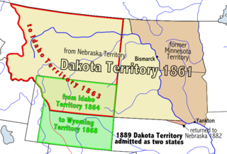
The Territory of Dakota was an organized incorporated territory of the United States that existed from March 2, 1861, until November 2, 1889, when the final extent of the reduced territory was split and admitted to the Union as the states of North and South Dakota.
The Big Sioux River is a tributary of the Missouri River in eastern South Dakota and northwestern Iowa in the United States. It flows generally southwardly for 419 mi (674 km), and its watershed is 9,006 sq mi (23,330 km2). The United States Board on Geographic Names settled on "Big Sioux River" as the stream's name in 1931. The river was named after the Lakota people which was known by them as Tehankasandata, or Thick Wooded River.

Black Elk Peak is the highest natural point in the U.S. state of South Dakota and the Midwestern United States. It lies in the Black Elk Wilderness area, in southern Pennington County, in the Black Hills National Forest. The peak lies 3.7 mi (6.0 km) west-southwest of Mount Rushmore. At 7,244 feet (2,208 m), it is the highest summit in the United States east of the Rocky Mountains. Though part of the North American Cordillera, it is generally considered to be geologically separate from the Rocky Mountains.
The Dakota are a Native American tribe and First Nations band government in North America. They compose two of the three main subcultures of the Sioux people, and are typically divided into the Eastern Dakota and the Western Dakota.

The structure of the government of South Dakota is based on that of the federal government, with three branches of government: executive, legislative, and judicial. The structure of the state government is laid out in the Constitution of South Dakota, the highest law in the state. The constitution may be amended either by a majority vote of both houses of the legislature, or by voter initiative.

Milesville is an unincorporated community in southwestern Caswell County, North Carolina, United States, located east of Cherry Grove.

Kristi Lynn Noem is an American politician who became the 33rd governor of South Dakota in 2019. A member of the Republican Party, she was the U.S. representative for South Dakota's at-large congressional district from 2011 to 2019, and a member of the South Dakota House of Representatives for the 6th district from 2007 to 2011.
Topbar, South Dakota, is a populated place in West Haakon township in Haakon County, South Dakota, United States, near to Milesville, South Dakota and Philip, South Dakota.


