Related Research Articles
Castle Air Force Base is a former United States Air Force Strategic Air Command base in California, located northeast of Atwater, northwest of Merced, and about 115 miles (185 km) south of Sacramento.
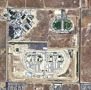
War Eagle Field is a former airfield located in the Mojave Desert, about 5-mile (8.0 km) west of Lancaster, California. It is currently used as a detention facility.

Wendover Air Force Base is a former United States Air Force base in Utah now known as Wendover Airport. During World War II, it was a training base for B-17 and B-24 bomber crews. It was the training site of the 509th Composite Group, the B-29 unit that carried out the atomic bombings of Hiroshima and Nagasaki.

Walker Air Force Base is a closed United States Air Force base located three miles (5 km) south of the central business district of Roswell, New Mexico. It was opened in 1941 as an Army Air Corps flying school and was active during World War II and the postwar era as Roswell Army Air Field (RAAF). During the early years of the Cold War, it became the largest base of the Strategic Air Command. It is also known for the Roswell UFO incident, an event that occurred on 4 July 1947. It is alleged that a "flying disc" crashed during a severe thunderstorm near the base at Corona, New Mexico.

Sharpe Field is a closed private use airport located six nautical miles northwest of the central business district of Tuskegee, a city in Macon County, Alabama, United States. This airport is privately owned by the Bradbury Family Partnership.
Yucca Army Airfield is a former military airfield located about 1 mile (1.6 km) west of Yucca, in Mohave County, Arizona, United States. It is on the east side of Interstate 40, 25 miles (40 km) south of Kingman. It is now used as a private facility owned by Fiat Chrysler Automobiles named Chrysler Arizona Proving Grounds.

Gila Bend Air Force Auxiliary Field is a United States Air Force auxiliary airfield used as an emergency landing facility by Luke Air Force Base and Davis-Monthan Air Force Base aircraft and units from other nearby bases using the Barry M. Goldwater Air Force Range complex. The airfield is located 3.5 miles south of Interstate 8 and the central business district of Gila Bend, in Maricopa County, Arizona, United States.

Hancock Field is a former airport and military airfield about 2 miles (3.2 km) south-southeast of Santa Maria, California. Also known as Santa Maria Municipal Airport, the airport was closed about 1959 and today is the site of Allan Hancock College.
W. R. Byron Airport is a privately owned, private use airport in Riverside County, California, United States. It is located four nautical miles northwest of the central business district of Blythe, California, within the city limits.

Rankin Field is a former airport and military airfield located approximately 7 miles (11 km) southeast of Tulare, California. It was a United States Army Air Forces basic flying training facility during World War II. It is now an agricultural and light industrial site.
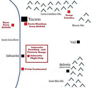
The Sahuarita Air Force Range, also known as the Sahuarita Bombing & Gunnery Range, was built just east of Sahuarita, Arizona, in 1942. It was used for the training of bombardiers, aerial gunners, anti-aircraft gunners, and others during World War II and the Korean War. The abandoned Sahuarita Flight Strip is located in the southwestern corner of the range, and was used as an emergency flight strip until 1978. Before deactivation, the airspace over the range was protected by its own restricted area, R-310.

Eagle Pass Army Airfield is a former World War II military airfield complex. It is located 10.6 miles (17.1 km) north of Eagle Pass, Texas. It operated as a training base for the United States Army Air Forces from 1943 until 1945.

Bangor Air National Guard Base is a United States Air National Guard base. Created in 1927 as the commercial Godfrey Field, the airfield was taken over by the U.S. Army just before World War II and renamed Godfrey Army Airfield and later Dow Army Airfield. It became Dow Air Force Base in 1947, when the newly formed U.S. Air Force took over many Army air assets.

The 30th Tactical Missile Squadron is an inactive United States Air Force unit. In 1985 the squadron was formed by combining three United States Air Force and Army Air Forces units that had served in World War II and the Cold War into a single unit with a common heritage. However, the combined unit has not since been active.

Milford is a town in Penobscot County, Maine, United States. It is located across the Penobscot River from the city of Old Town. The population of Milford was 3,069 at the 2020 census. The town's slogan is the "Best little town by a dam site," referring to the Milford Dam abutting Milford on the Penobscot River, south of the Penobscot Indian Island Reservation.
Chico Army Airfield auxiliary fields were a number of airfields used during World War II to support the Chico Army Airfield. On September 11, 1941, the US Army rented from the City of Chico a small 1930's airport that sat on 160 acres (0.65 km2) of land. The Airfield was five miles (8.0 km) north of the city center. The Army built up the small airport into the Chico Army Airfield. From the Chico Army Airfield operated the: United States Army Air Corps's Army Air Forces Basic Flying School, the Army Air Force Pilot School, the 10th Base Headquarters an Air Base Squadron and the 433rd Army Air Force Base Unit or Combat Crew Training Station of Fighter. To support the training of the many pilots, Chico Army Airfield operated a number of auxiliary airfields. Some auxiliary fields were no more than a landing strip runway, others were other operation airfield that supported the training at the Chico Army Airfield.

Gardner Army Airfield auxiliary fields were a number of airfields used during World War II to support the Gardner Army Airfield. May 12, 1943 the US Army leased 1,396.36 acres for Gardner Field, located 9 miles southeast of Taft, California. Gardner Army Airfield was named after Major John H. Gardner, a World War I aviator hero. The Army built three runways to support training activities need for World War II. From Gardner Army Airfield the United States Army Air Corps's Western Flying Training Command started training the needed pilots. To support the training of the many pilots, Gardner Army Airfield operated a number of auxiliary airfields. Some auxiliary fields were no more than a landing strip, others were other operation airfield that supported the training at the Gardner Army Airfield. The Vultee BT-13 Valiant and Boeing-Stearman Model 75 were the most common planes used for training at Gardner Army Airfields, but large bombers were trained also. Gardner Army Airfield auxiliary fields were:
Victorville Army Airfield auxiliary fields were four airfields used during World War II to support the Victorville Army Airfield pilot training near Victorville, California, and Adelanto, California. After the war the Victorville Army Airfield was renamed George Air Force Base on January 13, 1948. The airfields were built in 1941 by the United States Army Air Corps just before the war. Victorville Army Airfield covered 2,200-acre in the Mojave Desert. The US Army held a groundbreaking ceremony on 12 July 1941. The base, called Victorville Army Flying School, was ready to use before the attack on Pearl Harbor on December 7, 1941. The Army built four runways in a triangle configuration, with one runway down the middle of the triangle. Seven hangars were built to support operation. On April 23, 1943, the base was renamed Victorville Army Airfield.
References
- ↑ Freeman, Paul. "Abandoned & Little-Known Airfields: Northern Maine". Abandoned & Little-Known Airfields . Retrieved 16 March 2014.
44°58′28.32″N68°27′30.94″W / 44.9745333°N 68.4585944°W
Former military installations in Maine | ||||||||||||
|---|---|---|---|---|---|---|---|---|---|---|---|---|
| Army |
|  | ||||||||||
| Air Force |
| |||||||||||
| Navy |
| |||||||||||
| Coast Guard |
| |||||||||||
| National Guard |
| |||||||||||