
Youngstown is a city in the U.S. state of Ohio, and the largest city and county seat of Mahoning County. According to the 2020 United States Census, Youngstown had a city population of 60,068. It is a principal city of the Youngstown–Warren metropolitan area, which had a population of 541,243 in 2020, making it the 107th-largest metropolitan area in the United States and seventh-largest metro area in Ohio.

Delridge is a district in West Seattle, Washington, United States that stretches along Delridge Way, an arterial that follows the eastern slope of the valley of Longfellow Creek, from near its source just within the southern city limits north to the West Seattle Bridge over the Duwamish River.

The Ohio and Erie Canal was a canal constructed during the 1820s and early 1830s in Ohio. It connected Akron with the Cuyahoga River near its outlet on Lake Erie in Cleveland, and a few years later, with the Ohio River near Portsmouth. It also had connections to other canal systems in Pennsylvania.

The Mahoning River is a river located in northeastern Ohio and a small portion of western Pennsylvania. Flowing primarily through several Ohio counties, it crosses the state line into Pennsylvania before joining with the Shenango River to form the Beaver River. The Mahoning River drops from 1,296 feet (395 m) at the headwaters near Winona to 761 feet (232 m) at the outfall near Mahoningtown, Pennsylvania. It is part of the Ohio River watershed.
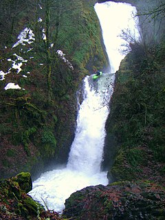
The Bridal Veil Falls is a waterfall located on Bridal Veil Creek along the Columbia River Gorge in Multnomah County, Oregon, United States. The waterfall is accessible from the historic Columbia River Highway and Interstate 84. Spanning two tiers on basalt cliffs, it is the only waterfall which occurs below the historic Columbia Gorge Scenic Highway. The Bridal Veil Falls Bridge, built in 1914, crosses over the falls, and is listed on the National Register of Historic Places.

The Jones and Laughlin Steel Company began as the American Iron Company, founded in 1852 by Bernard Lauth and B. F. Jones, a few miles south of Pittsburgh along the Monongahela River. Lauth's interest was bought in 1854 by James Laughlin. The first firm to bear the name of Jones and Laughlin was organized in 1861 and headquartered at Third & Ross in downtown Pittsburgh.
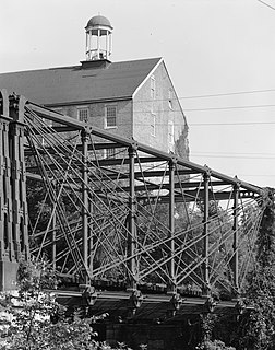
The Bollman Truss Railroad Bridge at Savage, Maryland is the sole surviving example of a revolutionary design in the history of American bridge engineering. The 160-foot (48.8 m) double-span is a suspension truss bridge. The first Bollman bridge was installed on the site; however, the current bridge is not the original. The current bridge was built in 1852 and moved to the site thirty years later. It is one of the oldest standing iron railroad bridges in the United States. Currently, however, it is in use carrying the Savage Mill Trail across the Little Patuxent River.

Idora Park (1899–1984) was a northeastern Ohio amusement park popularly known as "Youngstown's Million Dollar Playground."
The Whitewater Canal, which was built between 1836 and 1847, spanned a distance of 76 miles (122 km) and stretched from Lawrenceburg, Indiana on the Ohio River to Hagerstown, Indiana near the West Fork of the White River.

Mill Creek Park is a metropolitan park located in Youngstown, Ohio. The Trust for Public Land ranks one part of Mill Creek as the 142nd largest park located within the limits of a US city.

Pugh's Mill Covered Bridge is a registered historic structure near Oxford, Ohio, listed in the National Register on 1975-06-05. This wooden bridge was built in 1869 over Four Mile (Talawanda) Creek and is one of two remaining covered bridges in Butler County, Ohio. The other is the Bebb Park or State Line covered bridge built in 1868.

Tinkers Creek Aqueduct is an aqueduct that was constructed to bridge the Ohio and Erie Canal over Tinkers Creek near its confluence with the Cuyahoga River in Valley View, Ohio. It is a relatively rare surviving example of an Ohio and Erie Canal aqueduct. It was originally constructed in 1825-1827 by, and re-built due to flood damage in 1845 and 1905. Tinkers Creek Aqueduct was included in a National Historic Landmark district established in 1966, and it was separately listed on the National Register of Historic Places in 1979. The original Tinkers Creek Aqueduct was a wood plank, steel truss, and Ashlar-sandstone structure constructed in 1827, south of the present aqueduct's location. Cuyahoga River and Tinkers Creek flooding caused continual damage to the original aqueduct, so successive structures were built in 1845 and 1905 in the present location. Today, Tinkers Creek Aqueduct is the only aqueduct which remains of the four original aqueducts in the Cuyahoga Valley. Of Furnace Run Aqueduct, Mill Creek Aqueduct, Peninsula Aqueduct, and Aqueduct; Mill Creek Aqueduct, of newer construction, is the only aqueduct which still carries Ohio and Erie Canal water. After 102 years of flooding, weathering, and deterioration, Tinkers Creek Aqueduct was removed in 2007. The National Park Service is currently working on Phase II of the project to reconstruct it from newer materials.

Chevelon Creek Bridge is a historic road bridge located about 12 miles (19 km) southeast of Winslow, in Navajo County, eastern Arizona, United States. It is a steel Warren Pony truss bridge over Chevelon Creek, built on the first permanent road connecting Holbrook, the seat of Navajo County, and Winslow. When built, the road was regionally important in northern Arizona as well as being a segment of an early national highway at the time automobile traffic was growing and national roads were first being formed. The bridge was listed on the National Register of Historic Places in 1983 for being a rare design in Arizona, part of an early transnational roadway, one of the first bridges built by Arizona after statehood in 1912, and being in nearly original condition.

The Pine Mill Bridge is an historic structure located in Wildcat Den State Park in rural Muscatine County, Iowa, United States. It was built in 1878 near the Pine Creek Gristmill, the only place in Iowa where a mill and bridge combination remains in place. The bridge was listed on the National Register of Historic Places in 1998 as a part of the Highway Bridges of Iowa MPS.
Indian Mound Reserve is a public country park near the village of Cedarville, Ohio, United States. Named for two different earthworks within its bounds — the Williamson Mound and the Pollock Works — the park straddles Massies Creek as it flows through a small canyon.

Valley Railroad Bridge or Gish Branch Bridge is a historic limestone arch bridge located over Gish Branch at Salem, Virginia. It was built in 1873 by the firm of Claiborne Rice (C.R.) Mason, under the local guidance of Thomas Menifee, engineer and employee of Mason. Mason was head of a syndicate hoping to link major railways of the north and south at Salem, Virginia - specifically by linking the Atlantic, Mississippi and Ohio Railroad with the Baltimore and Ohio Railroad, two of the major railways of the era.
Moore's Ford Bridge was a historic structure located northeast of Monticello, Iowa, United States. It spanned White Water Creek for 100 feet (30 m). The Jones County Board of Supervisors received a petition for a bridge at this location in September 1877. While they agreed there was a need, they put off erecting a bridge here until other bridges in the county were completed at major crossings. They finally authorized this bridge in September 1883 and contracted with the Morse Bridge Company of Youngstown, Ohio to erect a single Pratt through truss span here. It was completed in June 1884 for $2,305. The bridge was listed on the National Register of Historic Places in 1998. It has subsequently been taken down.
The Fish Creek Bridge is a historic structure that was originally located east of Salem, Iowa, United States. The span carried Hickory Road over Fish Creek for 50 feet (15 m). It is a small-scale, wrought-iron bridge that the Henry County Board of Supervisors bought from the George E. King Bridge Company of Des Moines in 1893 for $410.80. It was believed to have been fabricated by their parent company, King Iron Bridge Company of Cleveland, and assembled by local laborers. Its historical significance derived from its being an uncommon variant of the Pratt truss. It was listed on the National Register of Historic Places in 1998. Subsequently, the bridge has been replaced at its original location, and the historic structure was moved to Oakland Mills Park.
The historic bridges at the Lancaster campus of Ohio University were moved to the campus and sit about a 100 yards apart. The bridges were built in 1881 and 1884-85 very close to each other, both crossing Poplar Creek, and while the first-built is a wood-and-steel covered bridge and the second-built is all-steel, they are similar in design. Original and current locations of both bridges may be seen in OpenStreetMap linked at right.

The Martin Road Bridge is a former road bridge which carried Martin Road across the Shiawassee River in Caledonia Township near Corunna. It was one of the oldest metal through truss highway bridges in Michigan, and was listed on the National Register of Historic Places in 1991. As of 2016, the bridge has been removed from its original site, and will be restored and reassembled at the Auburn Valley State Park in Yorklyn, Delaware.


