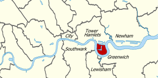
London Docklands is the riverfront and former docks in London. It is located in inner east and southeast London, in the boroughs of Southwark, Tower Hamlets, Lewisham, Newham and Greenwich. The docks were formerly part of the Port of London, at one time the world's largest port. After the docks closed, the area had become derelict and poverty-ridden by the 1980s. The Docklands' regeneration began later that decade; it has been redeveloped principally for commercial and residential use. The name "London Docklands" was used for the first time in a government report on redevelopment plans in 1971 and has since been almost universally adopted. The redevelopment created wealth, but also led to some conflict between the new and old communities in the area.
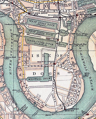
The Isle of Dogs is a large peninsula bounded on three sides by a large meander in the River Thames in East London, England, which includes the Cubitt Town, Millwall and Canary Wharf districts. The area was historically part of the Manor, Hamlet, Parish and, for a time, the wider borough of Poplar. The name had no official status until the 1987 creation of the Isle of Dogs Neighbourhood by Tower Hamlets London Borough Council. It has been known locally as simply "the Island" since the 19th century.
Limehouse is a district in the London Borough of Tower Hamlets in East London. It is 3.9 miles (6.3 km) east of Charing Cross, on the northern bank of the River Thames. Its proximity to the river has given it a strong maritime character, which it retains through its riverside public houses and steps, such as The Grapes and Limehouse Stairs. It is part of the traditional county of Middlesex. It became part of the ceremonial County of London following the passing of the Local Government Act 1888, and then part of Greater London in 1965.

Poplar is a district in East London, England, now part of the London Borough of Tower Hamlets. Five miles (8 km) east of Charing Cross, it is part of the East End.
The Port of London is that part of the River Thames in England lying between Teddington Lock and the defined boundary with the North Sea and including any associated docks. Once the largest port in the world, it was the United Kingdom's largest port as of 2020. Usage is largely governed by the Port of London Authority ("PLA"), a public trust established in 1908; while mainly responsible for coordination and enforcement of activities it also has some minor operations of its own.

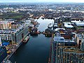
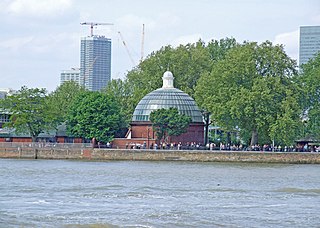
The West India Docks are a series of three docks, quaysides, and warehouses built to import goods from, and export goods and occasionally passengers to the British West Indies. Located on the Isle of Dogs in London, the first dock opened in 1802. Following their commercial closure in 1980, the Canary Wharf development was built around the wet docks by narrowing some of their broadest tracts.

Blackwall is an area of Poplar, in the London Borough of Tower Hamlets, East London. The neighbourhood includes Leamouth and the Coldharbour conservation area.

Millwall is a district on the western and southern side of the Isle of Dogs, in east London, England, in the London Borough of Tower Hamlets. It lies to the immediate south of Canary Wharf and Limehouse, north of Greenwich and Deptford, east of Rotherhithe, west of Cubitt Town, and has a long shoreline along London's Tideway, part of the River Thames. It was part of the County of Middlesex and from 1889 the County of London following the passing of the Local Government Act 1888, it later became part of Greater London in 1965.
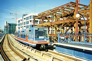
The London Docklands Development Corporation (LDDC) was a quango agency set up by the UK Government in 1981 to regenerate the depressed Docklands area of east London. During its seventeen-year existence, it was responsible for regenerating an area of 8.5 square miles (22 km2) in the London Boroughs of Newham, Tower Hamlets and Southwark. LDDC helped to create Canary Wharf, Surrey Quays shopping centre, London City Airport, ExCeL Exhibition Centre, London Arena and the Docklands Light Railway, bringing more than 120,000 new jobs to the Docklands and making the area highly sought after for housing. Although initially fiercely resisted by local councils and residents, today it is generally regarded as having been a success and is now used as an example of large-scale regeneration, although tensions between older and more recent residents remain.
North Greenwich is a formal 19th century name for an area now in Millwall situated at the very southern tip of the Isle of Dogs, in the London Borough of Tower Hamlets. It lies to the south of the commercial estates of West India Docks including Canary Wharf and has a short shoreline along London's Tideway part of the River Thames.

Cubitt Town is a district on the eastern side of the Isle of Dogs in London, England. This part of the former Metropolitan Borough of Poplar was redeveloped as part of the Port of London in the 1840s and 1850s by William Cubitt, Lord Mayor of London (1860–1862), after whom it is named. It is on the east of the Isle, facing the Royal Borough of Greenwich across the River Thames. To the west is Millwall, to the east and south is Greenwich, to the northwest Canary Wharf, and to the north — across the Blue Bridge — is Blackwall. The district is situated within the Blackwall & Cubitt Town Ward of Tower Hamlets London Borough Council.
Originally called the Commercial Railway, the London and Blackwall Railway (L&BR) in east London, England, ran from Minories to Blackwall via Stepney, with a branch line to the Isle of Dogs, connecting central London to many of London's docks. It was operational from 1840 until 1926 and 1968, closing after the decline of inner London's docks. Much of its infrastructure was reused as part of the Docklands Light Railway. The L&BR was leased by the Great Eastern Railway in 1866, but remained independent until absorbed into the London and North Eastern Railway at the 1923 Grouping. Another branch was opened in 1871, the Millwall Extension Railway.

East London is the northeastern part of London, England, east of the ancient City of London and north of the River Thames as it begins to widen. East London developed as London's docklands and the primary industrial centre. The expansion of railways in the 19th century encouraged the eastward expansion of the East End of London and a proliferation of new suburbs. The industrial lands of East London are today an area of regeneration, which are well advanced in places such as Canary Wharf and ongoing elsewhere.

The East India Docks were a group of docks in Blackwall, east London, north-east of the Isle of Dogs. Today only the entrance basin and listed perimeter wall remain visible.
Millwall Docks was a railway station located in the Millwall area of the Isle of Dogs in east London. It was between South Dock and North Greenwich stations on the Millwall Extension Railway (MER) branch of the London and Blackwall Railway (LBR). It opened in December 1871 and was situated on the corner of Glengall Road and East Ferry Road, serving the Millwall Docks.
John Aird & Co. was once a leading British civil engineering business based in London.
The A1206, also known as the Isle of Dogs Distributor Road, is a crescent-shaped ring road around the Isle of Dogs, in the East End of London. It is made up of Westferry Road, Manchester Road and Prestons Road and is the main road through the area, connecting parts of the London Docklands.
Sir John McDougall was an English businessman and an east London politician who chaired London County Council for a year from March 1902.

Sir John McDougall Gardens is a grassed and wooded area along the River Thames on the Isle of Dogs in London, England. It houses a playground, an outdoor gym and a Thames-side path. It covers just over 6 acres (2.4 ha), between the River Thames and Westferry Road.