
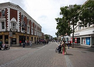
Chatham is a town located within the Medway unitary authority in the ceremonial county of Kent, England. The town forms a conurbation with neighbouring towns Gillingham, Rochester, Strood and Rainham.

Rochester is a town in the unitary authority of Medway, in Kent, England. It is at the lowest bridging point of the River Medway, about 30 miles (50 km) from London. The town forms a conurbation with neighbouring towns Chatham, Rainham, Strood and Gillingham. Rochester was a city until losing its status as one in 1998 following the forming of Medway and failing to protect its status as a city. There have been ongoing campaigns to reinstate the city status for Rochester.
Gravesend is a town in northwest Kent, England, situated 21 miles (35 km) east-southeast of Charing Cross on the south bank of the River Thames and opposite Tilbury in Essex. Located in the diocese of Rochester, it is the administrative centre of the Borough of Gravesham. Gravesend marks the eastern limit of the Greater London Built-up Area, as defined by the UK Office for National Statistics.
Gravesham is a local government district with borough status in north-west Kent, England. The council is based in its largest town of Gravesend. The borough is indirectly named after Gravesend, using the form of the town's name as it appeared in the Domesday Book of 1086. The district also contains Northfleet and a number of villages and surrounding rural areas.

Tilbury is a port town in the borough of Thurrock, Essex, England. The present town was established as separate settlement in the late 19th century, on land that was mainly part of Chadwell St Mary. It contains a 16th century fort and an ancient cross-river ferry. Tilbury is part of the Port of London with a major deep-water port which contributes to the local economy. Situated 24 miles (38.5 km) east of central London and 23 miles (37 km) southwest of Southend-on-Sea, it is also the southernmost point in Essex.
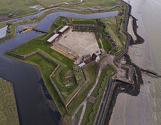
Tilbury Fort, also known historically as the Thermitage Bulwark and the West Tilbury Blockhouse, is an artillery fort on the north bank of the River Thames in England. The earliest version of the fort, comprising a small blockhouse with artillery covering the river, was constructed by King Henry VIII to protect London against attack from France as part of his Device programme. It was reinforced during the 1588 Spanish Armada invasion scare, after which it was reinforced with earthwork bastion, and Parliamentary forces used it to help secure the capital during the English Civil War of the 1640s. Following naval raids during the Anglo-Dutch Wars, the fort was enlarged by Sir Bernard de Gomme from 1670 onwards to form a star-shaped defensive work, with angular bastions, water-filled moats and two lines of guns facing onto the river.

Cobham is a village and civil parish in the borough of Gravesham in Kent, England. The village is located 6 miles (10 km) south-east of Gravesend, and just south of Watling Street, the Roman road from Dover to London. The parish, which includes the hamlet of Sole Street, covers an area of 1,240 hectares and had a population of 1,469 at the 2011 Census, increasing from 1,328 at the 2001 Census.

Northfleet is a town in the borough of Gravesham in Kent, England. It is located immediately west of Gravesend, and on the border with the Borough of Dartford. Northfleet has its own railway station on the North Kent Line, just east of Ebbsfleet International railway station on the High Speed 1 line.

New Tavern Fort is an historic artillery fort in Gravesend, Kent. Dating mostly from the 18th and 19th centuries, it is an unusually well-preserved example of an 18th-century fortification and remained in use for defensive purposes until the Second World War. It was built during the American War of Independence to guard the Thames against French and Spanish raiders operating in support of the newly formed United States of America. It was redesigned and rebuilt in the mid-19th century to defend against a new generation of iron-clad French warships.

Shornemead Fort is a now-disused artillery fort that was built in the 1860s to guard the entrance to the Thames from seaborne attack. Constructed during a period of tension with France, it stands on the south bank of the river at a point where the Thames curves sharply north and west, giving the fort long views up and downriver in both directions. It was the third fort constructed on the site since the 18th century, but its location on marshy ground led to major problems with subsidence. The fort was equipped for a time with a variety of large-calibre artillery guns which were intended to support two other nearby Thamesside forts. However, the extent of the subsidence meant that it became unsafe for the guns to be fired and the fort was disarmed by the early 20th century.
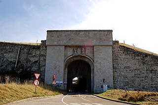
Verne Citadel is a 19th-century citadel on the Isle of Portland, Dorset, England. Located on the highest point of Portland, Verne Hill, it sits in a commanding position overlooking Portland Harbour, which it was built to defend. It later became HM Prison The Verne in 1949.

Meopham is a large linear village and civil parish in the Borough of Gravesham in north-west Kent, England, lying to the south of Gravesend. The parish covers 6.5 square miles (17 km2), and comprises two villages and two smaller settlements; it had a population of 6,795 at the 2021 census. Meopham village is sometimes described as the longest settlement in England although others such as Brinkworth and Sykehouse make the same claim. Meopham is one of the longest linear settlements in Europe, being 7 miles (11 km) in length.

Milton-next-Gravesend is an ecclesiastical parish in the north-west of Kent, England, which is now part of the Gravesend built-up area.

All Saints Pastoral Centre is a complex of buildings at London Colney on the southern outskirts of St Albans, Hertfordshire, England. It was built as a convent for the Anglican Society of All Saints Sisters of the Poor.

The Gravesend Town Pier is located in Gravesend, Kent. It was designed by William Tierney Clark and built in 1834 on the site of the earlier Town Quay. Over 3 million passengers were served between 1835 and 1842, but around 1900, this pier fell into disuse due to the arrival of the railways.

Shorne Wood Country Park is located between Strood and Gravesend, in the English county of Kent. It was once part of a large estate, later passed to the county council to be used as a country park.

The Great Lines Heritage Park is a complex network of open spaces in the Medway Towns, connecting Chatham, Gillingham, Brompton and the Historic Dockyard. The long military history of the towns has dominated the history of the site and the park. The Great Lines Heritage Park, consists of Fort Amherst, Chatham Lines, the Field of Fire, Inner Lines, Medway Park together with the Lower Lines.
Milton Blockhouse was an artillery fortification constructed as part of Henry VIII's Device plan of 1539, in response to fears of an imminent invasion of England. It was built at Milton, near Gravesend in Kent at a strategic point along the River Thames, and was operational by 1540. Equipped with 30 pieces of artillery and a garrison of 12 men and a captain, it was probably a two-storey, D-shaped building, designed to prevent enemy ships from progressing further up the river or landing an invasion force. It was stripped of its artillery in 1553 and was demolished between 1557 and 1558; nothing remains of the building above ground, although archaeological investigations in the 1970s uncovered parts of the blockhouse's foundations.

Gravesend Blockhouse was an artillery fortification constructed as part of Henry VIII's Device plan of 1539, in response to fears of an imminent invasion of England by European countries. It was built at Gravesend in Kent at a strategic point along the River Thames and was operational by 1540. A two-storey, D-shaped building built from brick and stone, it had a circular bastion overlooking the river and gun platforms extending out to the east and west. It functioned in conjunction with Tilbury Fort on the other side of the river, and was repaired in 1588 to deal with the threat of Spanish invasion, and again in 1667 when the Dutch navy raided the Thames. A 1778 report recommended alterations to the blockhouse and its defences, leading to the remodelling of the gun platforms and the construction of the new, larger New Tavern Fort alongside it. In the 1830s the government decided to rely entirely on the newer fort and the old blockhouse was demolished in 1844. Its remains were uncovered in archaeological excavations between 1975 and 1976.

Gravesend Town Hall is a municipal building in the High Street in Gravesend, Kent, England. The town hall, which was the headquarters of Gravesend Municipal Borough Council, is a Grade II* listed building.


