
Excelsior is a city in Hennepin County, Minnesota, United States. Excelsior's historic commercial district along Water Street is listed on the National Register of Historic Places, and the town has many Victorian-era houses. On Lake Minnetonka's southern shore, the community serves as a local tourism destination for shoppers, boaters, and restaurant-goers.

Minnetonka is a city in Hennepin County, Minnesota, United States. A western suburb of the Twin Cities, Minnetonka is located about 10 miles (16 km) west of downtown Minneapolis. At the 2020 census, the city's population was 53,781.

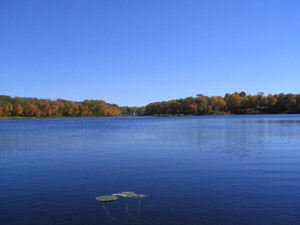
Lake Minnetonka is a lake located about 16 miles (26 km) west-southwest of Minneapolis, Minnesota. Lake Minnetonka has about 23 named bays and areas. The lake lies within Hennepin and Carver counties and is surrounded by 13 incorporated municipalities. At 14,528 acres (5,879 ha), it is Minnesota's ninth largest lake. It is a popular spot for local boaters, sailors, and fishermen.

Lake Harriet is a lake in southwest Minneapolis, south of Bde Maka Ska and north of Minnehaha Creek. The lake is surrounded by parkland as part of Minneapolis’ Chain of Lakes. The lake has an area of 335 acres (1.36 km2) and a maximum depth of 85 feet (26 m).

Lake Hiawatha is located just north of Lake Nokomis in Minneapolis, Minnesota. It was purchased by the Minneapolis Park and Recreation Board in 1922 for $550,000. At that time the lake was a marsh known as Rice Lake, but over four years, the park system transformed the wetland into a lake surrounded by a park.
Saunders Lake is located in the United States state of Minnesota. It is a 70-acre (280,000 m2) lake that is west-southwest of Minneapolis–St. Paul in the Minneapolis suburbs of Mound and Minnetrista.

Hale is a neighborhood near the southern edge of Minneapolis. It lies south of Minnehaha Creek, north of 55th Street, east of Chicago Avenue, and west of Cedar Avenue. The neighborhood takes its name from the local public school, Nathan Hale. Nathan Hale is a K-4 school. Most of the homes in the area were built in the 1920s and 30s. The regional parks forming the neighborhood's north and east borders give the neighborhood a recreational heart.
Christmas Lake is a spring-fed lake covering approximately 265 acres (1.1 km2) in the western Minneapolis suburbs of Shorewood and Chanhassen. The lake is crossed by the border of Hennepin and Carver counties, with most of the area lying within the jurisdiction of the former. Christmas Lake is known for its exceptional water clarity, the best in the Minneapolis metropolitan area, with a DNR-reported clarity level of 20 feet (6.10 m). This clarity can be attributed to the fact that Christmas Lake is a spring fed lake with a sandy bottom. Although relatively small in area, Christmas Lake becomes deep very quickly, forming the basin of a depression that extends all along "the Ridge". The steep nature of the shoreline means that many houses are built far above the lake with railed motorized carts to provide access to the docks at the water level.

Minnehaha is a steam-powered excursion vessel on Lake Minnetonka in the U.S. state of Minnesota. The vessel was originally in service between 1906 and 1926. After being scuttled in 1926, Minnehaha was raised from the bottom of Lake Minnetonka in 1980, restored, and returned to active service in 1996. The vessel operated uninterrupted on Lake Minnetonka until 2019. It is currently stored in a maintenance facility in the town of Excelsior.

Nokomis is a community in Minneapolis, Minnesota. It takes its name from Lake Nokomis. It comprises eleven smaller neighborhoods.

Ericsson is a neighborhood within the Nokomis community in Minneapolis. Its boundaries are East 42nd and 43rd Streets to the north, Hiawatha Avenue to the east, Minnehaha Parkway to the south, and Cedar Avenue to the west. The neighborhood is the site of Lake Hiawatha, which is connected to Minnehaha Creek. Ericsson shares a neighborhood organization with Standish, even though that neighborhood lies in the Powderhorn community; signs at the western, southern, and eastern boundaries of the neighborhood welcome you to "Standish-Ericsson".

Page is a neighborhood in the Nokomis community in Minneapolis. Its boundaries are the Minnehaha Creek to the north, Chicago Avenue to the east, Diamond Lake Road and East 55th Street to the south, and Interstate 35W to the west. Page shares a neighborhood organization with the Hale and Diamond Lake neighborhoods.
Lake Langdon in Mound, Minnesota, has an area of 144 acres (0.6 km2). Minnehaha Creek Watershed District (MCWD) charts show its maximum depth of 38 feet (12 m), though it would be classified as a shallow lake with a mean depth of 8.3 feet (2.5 m). It is named for R. V. Langdon, the first township clerk. It is located west of Commerce Boulevard and south of Lynwood Boulevard. Boats on the lake cannot navigate to the nearby Lake Minnetonka, though it overflows into Lost Lake, part of the Big Lake, through Langdon Bay Creek. It also serves as an outlet for Saunders Lake, to its west. The lake has a watershed area to surface area ratio of 6.5:1, meaning that it drains an area about 6½ times its size.
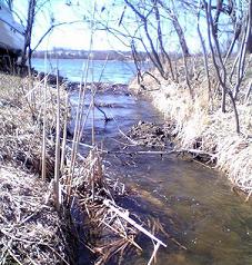
Langdon Bay Creek is a creek in Mound, Minnesota, United States. It is the outflow for, and connects, Lake Langdon to Mound's Lost Lake, which is part of Lake Minnetonka. Its length is perhaps 200 feet (61 m) long and it runs west to east. It is unnavigable and passes under Commerce Boulevard through a culvert. It has also been known as Sollie's Creek, named after the uncles of the Andrews Sisters who owned a grocery store to the south of it.
Six Mile Creek drains a large area south and west of Lake Minnetonka, in Hennepin and Carver Counties, Minnesota, United States. It ends on the western shore of Halstead's Bay, the westernmost bay of Lake Minnetonka. It runs through mostly agricultural land but this area is also seeing more residential development.

Lynnhurst is a neighborhood in the Southwest community in Minneapolis, Minnesota. Its boundaries are 46th Street to the north, Lyndale Avenue to the east, 54th Street to the south, and Penn Avenue to the west. It is located along the southeastern shore of Lake Harriet. Outflows from the lake run through a parkway for several city blocks to reach Minnehaha Creek.

Northwest Orient Airlines Flight 307 was a scheduled international flight with several domestic legs in the United States with the routing Washington, DC–Pittsburgh-Cleveland-Detroit–Madison–Rochester–Minneapolis-St. Paul–Winnipeg. On Tuesday, March 7, 1950, a Martin 2-0-2, registered N93050, was operating the flight when it collided with a flagpole at Fort Snelling National Cemetery on approach to Minneapolis-Saint Paul International Airport. During an attempt to make an emergency landing, a section of the left wing departed the aircraft, rendering it uncontrollable and causing it to crash into the Doughty family house in the Lynnhurst neighborhood of Minneapolis. All three crew members and ten passengers on board were killed, as were two children, Janet and Tom Doughty, and the family dog inside the house.
Patty Acomb is an American politician serving in the Minnesota House of Representatives since 2019. A member of the Minnesota Democratic–Farmer–Labor Party (DFL), Acomb represents District 45B in the western Twin Cities metropolitan area, which includes the city of Minnetonka and parts of Hennepin County.

Minnehaha Falls Lower Glen Trail is a popular hiking route in Minneapolis, Minnesota, United States. The 2.1-mile (3.4 km) trail loop begins and ends at the base of the iconic Minnehaha Falls. Hikers follow natural trails and elevated boardwalks through a sedimentary rock glen carved by Minnehaha Creek to its confluence with the Mississippi River where there is a sandy beach. Portions of the trail loop are rated moderate to challenging in difficulty.

Hidden Falls is a waterfall along the Mississippi River bluffs in Saint Paul, Minnesota, United States. The waterfall is within Hidden Falls Regional Park, a public park maintained by the City of Saint Paul. The main feature of the park is the small, spring-fed waterfall for which the park is named. The waterfall may be dry in periods of limited precipitation.