Icy Peak is a 7,073-foot (2,156-metre) Skagit Range mountain summit located in the North Cascades of Washington state. It is situated in North Cascades National Park at the head of Nooksack Cirque. High ridges connect it to Seahpo Peak and Mount Shuksan. An icefall occupies the northeast cirque, and small glaciers clad all sides of the peak. Precipitation runoff drains into the Nooksack and Baker Rivers.

Trapper Mountain is a 7,530-foot (2,300-metre) summit located in Chelan County of Washington state. It is part of the North Cascades Range. Trapper Mountain is situated southeast of Cascade Pass on the shared border of North Cascades National Park and Glacier Peak Wilderness. The nearest higher peak is Hurry-up Peak, 0.92 miles (1.48 km) to the west. Surface runoff from the mountain drains into Trapper Lake and tributaries of the Stehekin River.

The Triplets is a 7,240+ ft summit located in Skagit County of Washington state. This breccia triple pinnacle is part of the North Cascades Range. The Triplets is situated above Cascade Pass on the shared border of North Cascades National Park and Glacier Peak Wilderness. The nearest higher neighbor is Cascade Peak, 0.35 miles (0.56 km) to the west-northwest. Surface runoff from the mountain drains into the Cascade River.

Magic Mountain is a 7,610-foot (2,320-metre) mountain summit located on the shared boundary of Skagit County and Chelan County in Washington state. It is part of the North Cascades Range, a subset of the Cascade Range. Magic Mountain is situated southeast of Cascade Pass on the shared border of North Cascades National Park and Glacier Peak Wilderness. The nearest peak is Pelton Peak 0.4 miles (0.64 km) to the northeast, and the nearest higher peak is Hurry-up Peak 0.83 miles (1.34 km) to the south. The Yawning Glacier and Cache Col Glacier rest on its northern flank. Magic Mountain is at the northern end of the Ptarmigan Traverse. Surface runoff on the north side the mountain drains into the Stehekin River, while precipitation drains into the Cascade River from the southwest side.
Cache Col is a gap in a high ridge between Magic Mountain and Mix-up Peak. It's located at the highest part of Cache Glacier, on the shared boundary of Skagit County and Chelan County in Washington state. Cache Col is situated south of Cascade Pass on the shared border of North Cascades National Park and Glacier Peak Wilderness. Cache Col and the Cache Glacier are at the northern end of the Ptarmigan Traverse which is mountaineering route that provides access to remote peaks such as Mount Formidable and Dome Peak. Precipitation runoff on the north side of the col drains into the Stehekin River, while precipitation drains into the Cascade River from the south side.

Mount Misch is a remote 7,435 ft mountain summit in the North Cascades, in Skagit County of Washington state. It is the highest point of the Buckindy Range, or Buckindy Ridge. It is located 19 miles east-northeast of Darrington, Washington, and 15 miles north-northwest of Glacier Peak which is one of the Cascade stratovolcanoes. It is situated in the Glacier Peak Wilderness on land administered by the Mount Baker-Snoqualmie National Forest. Mount Misch was named by mountaineer and author Fred Beckey for his friend Peter Misch (1909-1987), University of Washington geology professor and mountaineer, who was renowned for his study of the North Cascades. Precipitation runoff from Mount Misch and the unnamed Goat Creek glacier on its east slope drains into tributaries of the Suiattle River and ultimately the Skagit River.

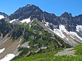
Hurry-up Peak is a 7,821-foot-elevation summit located on the shared boundary of Skagit County and Chelan County in Washington state. It is positioned on the crest of the North Cascades Range, and is set at the northern end of the Ptarmigan Traverse. Hurry-up Peak is situated southeast of Cascade Pass on the shared border of North Cascades National Park and Glacier Peak Wilderness. The nearest higher peak is Spider Mountain, 1.49 miles (2.40 km) to the south, with Magic Mountain 0.83 miles (1.34 km) to the north, and Trapper Mountain 0.7 miles (1.1 km) to the east. The S Glacier rests on the eastern flank of the peak and meltwater from it drains into Trapper Lake. Precipitation runoff on the east side the mountain drains into tributaries of the Stehekin River, while precipitation drains into the Cascade River from the west side. Ess Mountain and S Mountain are variant names for Hurry-up Peak. This geographical feature's name was officially adopted in 1969 by the U.S. Board on Geographic Names.

Mount Chaval is a craggy 7,127-foot (2,172-metre) mountain summit located in Skagit County of Washington state. Situated within the Glacier Peak Wilderness, Mount Chaval is positioned west of the crest of the North Cascades Range, approximately 15 miles northeast of the town of Darrington. It has two subsidiary peaks, East Peak and Middle Peak, each 7040 ft. Its nearest higher neighbor is Snowking Mountain, 2.51 miles (4.04 km) to the northeast. Precipitation runoff from Mount Chaval drains into tributaries of the Skagit River.

Snowking Mountain is a 7,433-foot (2,266-metre) summit located in Skagit County of Washington state. Situated within the Glacier Peak Wilderness, Snowking Mountain is positioned west of the crest of the North Cascades Range, approximately 18 miles northeast of the town of Darrington. It is set within the Glacier Peak Wilderness, on land managed by Mount Baker–Snoqualmie National Forest. Snowking has two subsidiary peaks, West Peak (7425 ft), and Middle Peak (7400 ft). A broad unnamed glacier known colloquially as Snowking Glacier rests on the north face. Downslope of that glacier are Snowking Lake, Found Lake, and Cyclone Lake. Mount Tommy Thompson is three miles to the northwest, and the nearest higher neighbor is Mount Misch, 5.75 miles (9.25 km) to the southeast. Precipitation runoff from Snowking Mountain drains into tributaries of the Skagit River.

Preacher Mountain is a broad summit located in King County of Washington state. It's located at the western edge of the Cascade Range and is within the Alpine Lakes Wilderness on land managed by Mount Baker-Snoqualmie National Forest. The nearest higher peak is Kaleetan Peak, 3.11 miles (5.01 km) to the southeast. The Pulpit is situated 2.19 miles to the northwest. Precipitation runoff from the mountain drains into tributaries of the Snoqualmie River.
Tricouni Peak is an 8,102-foot (2,469-metre) mountain summit located in Skagit County of Washington state. It is situated in North Cascades National Park, north of the North Klawatti Glacier and southeast of the Borealis Glacier. Its nearest higher peak is Primus Peak, 0.54 mi (0.87 km) to the west. Precipitation runoff from Tricouni drains into Thunder Creek. The peak is named for the tricouni which was used for traction on ice, and the approach to the peak involves traversing a glacier.
Kololo Peaks is an 8,200+ ft mountain located in the Glacier Peak Wilderness of the North Cascades in Washington state. The mountain is situated on the crest of the Cascade Range, on the shared border of Snohomish County and Chelan County, and also straddling the boundary between Mount Baker-Snoqualmie National Forest and Wenatchee National Forest. The nearest higher peak is Glacier Peak, 3.29 mi (5.29 km) to the north. Precipitation runoff and meltwater from the White River Glacier on the southeast slope drains into White River. On the west slope, the White Chuck Glacier drains into the White Chuck River, and the Suiattle Glacier and Honeycomb Glacier on the north and east sides drain into the Suiattle River. Surrounded by these glaciers, Fred Beckey in his Cascade Alpine Guide describes the mountain as being almost a nunatak.

Luahna Peak is an 8,400+ ft double summit mountain located in the Glacier Peak Wilderness of the North Cascades in Washington state. The true summit is 7400+ feet in elevation, and the northwest subpeak is 8,320+ feet. The mountain is situated in Chelan County, in the Wenatchee National Forest. Luahna Peak is the second highest in the Dakobed Range after Clark Mountain which is 1.04 mi (1.67 km) to the southeast, and Luahna lies 6.95 mi (11.18 km) southeast of Glacier Peak. The Richardson Glacier lies to the southeast of the summit, with the Pilz Glacier and Butterfly Glacier stretching across the northern slope. Precipitation runoff from the peak drains into the White River and Napeequa River, both tributaries of the Wenatchee River.

Sherpa Peak is an 8,605-foot (2,623-metre) granite summit located in the Stuart Range, in the Alpine Lakes Wilderness in Chelan County of Washington state. According to the USGS, this peak is "named for a local climbing club" that was "active in the area since the 1950s." The nearest higher peak is Mount Stuart, 0.41 mi (0.66 km) to the west, and Argonaut Peak lies 1.29 mi (2.08 km) to the east. The Sherpa Glacier lies on the northern slope of the peak. Precipitation runoff from the peak drains north into Mountaineer Creek, a tributary of Icicle Creek, or south into Ingalls Creek, all of which winds up in the Wenatchee River.

Johnson Mountain is a 6,721-foot (2,049-metre) mountain summit located in the Glacier Peak Wilderness of the North Cascades in Washington state. The mountain is situated in eastern Snohomish County, in the Mt. Baker-Snoqualmie National Forest. Its nearest higher peak is White Mountain, 3.3 mi (5.3 km) to the northeast, along with Indian Head Peak 3.38 mi (5.44 km) to the east. Precipitation runoff from the mountain drains into tributaries of the Sauk River. The mountain's name honors Mackinaw Johnson, a prospector who had a cabin in the vicinity.

Pinnacle Peak is a 7,360+ ft mountain summit in the North Cascades Range of Washington, United States. It is located within North Cascades National Park, between Pyramid Peak and Paul Bunyans Stump, which is the nearest higher peak. It rises steeply from Diablo Lake, one of the reservoirs on the Skagit River. It is part of a group of peaks that form the northern end of a chain running south through climbing destinations such as Colonial Peak and Snowfield Peak. Like many North Cascade peaks, Pinnacle Peak is more notable for its large, steep rise above local terrain than for its absolute elevation. Precipitation runoff from the mountain drains into Diablo Lake and Skagit River. The approach is via the Pyramid Lake Trail, starting near Diablo Dam on the North Cascades Highway. From the lake, there is route-finding up Pyramid Arm to Colonial Glacier.

Brahma Peak is a remote 8,078-foot (2,462-metre) mountain summit located on Chiwawa Ridge in the North Cascades, in Chelan County of Washington state. The mountain is situated in the Glacier Peak Wilderness, on land managed by the Wenatchee National Forest. Its nearest higher neighbor is Buck Mountain, 1.8 mi (2.9 km) to the north. Brahma and Buck are set on Chiwawa Ridge, and other notable peaks on this ridge include Fortress Mountain, Cirque Mountain, Napeequa Peak, Mount Berge, Bandit Peak, and Chiwawa Mountain. Precipitation runoff from Brahma and meltwater from its glacier remnants drains into Chiwawa River and Napeequa River, both tributaries of the Wenatchee River. Topographic relief is significant since the southwest lavender-colored schist cliffs of this peak rise nearly 4,000 feet above the Napeequa River Valley in approximately one mile.

Pinnacle Mountain is an 8,400+ ft granitic multi-peak massif located in the Chelan Mountains, in Chelan County of Washington state. The mountain is situated in Glacier Peak Wilderness of the North Cascades, on land managed by Wenatchee National Forest. Fred Beckey's Cascade Alpine Guide has the elevation of the highest pinnacle as 8,402 feet. Pinnacle Mountain ranks as the fourth-highest peak in the Chelan Mountains, and 75th-highest summit in Washington state. Its nearest higher neighbor is Saska Peak, 1.9 mi (3.1 km) to the southeast, and Emerald Peak is positioned 2.25 mi (3.62 km) to the east-southeast. Precipitation runoff from the peak drains into the Entiat River and Chelan River drainage basins.

Spark Plug Mountain is a 6,320-foot (1,930-metre) mountain summit located above the western shore of Glacier Lake, in eastern King County of Washington state. It's part of the Wenatchee Mountains, which are a subset of the Cascade Range, and is situated in the Alpine Lakes Wilderness, on land managed by Mount Baker-Snoqualmie National Forest. The nearest higher neighbor is Surprise Mountain, 1.0 mi (1.6 km) to the southeast, and Thunder Mountain is set above the eastern shore of Glacier Lake. The Pacific Crest Trail skirts this lake as it passes between Spark Plug and Thunder. Spark Plug Lake, elevation 5,587-ft, lies immediately below the north aspect of the mountain, and Little Spark Plug is the 6,016-ft peak on the north side of this lake. Precipitation runoff from the mountain drains into Surprise Creek and Deception Creek, both tributaries of the Skykomish River.

Jove Peak is a 6,007 ft (1,830 m) mountain summit located 5 mi (8.0 km) north of Stevens Pass on the common border of Snohomish County with Chelan County in Washington state. This peak is situated 12 mi (19 km) west of Lake Wenatchee, in the Henry M. Jackson Wilderness, on land managed by Mount Baker-Snoqualmie National Forest and Okanogan-Wenatchee National Forest. Jove Peak was named by Albert Hale Sylvester for Jove in association with the mythology-theme of nearby Minotaur and Theseus Lakes which are near Labyrinth Mountain, 2.5 mi (4.0 km) to the northeast. Precipitation runoff from the peak drains west into headwaters of Rapid River, or east into Rainy Creek which is a tributary of the Little Wenatchee River.